 Service

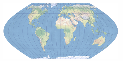
Eckert VI Projection
Eckert VI Projection is a pseudocylindrical equal-area map projection proposed by German cartographer Max Eckert in 1906. As the sixth and most widely recognized projection in the Eckert series, it represents a significant departure from the earlier Eckert I–V designs. Unlike its predecessors, Eckert VI features equally spaced straight parallels and curved meridians that are elliptical arcs, with the central meridian appearing as a straight line half the length of the equator. The poles are represented as points (rather than lines), creating a more conventional and visually appealing world map while maintaining strict equal-area properties. This projection is often compared favorably to the Robinson projection in terms of aesthetic balance.
2026-04-03 15:47:54
Eckert II Projection
Eckert II Projection is a pseudocylindrical equal-area map projection proposed by German cartographer Max Eckert in 1906. As the second projection in the Eckert series, it shares the same geometric framework as Eckert I—equally spaced straight meridians interrupted at the equator, a central meridian half the length of the equator, and uniformly distributed straight parallels—but introduces a critical mathematical modification to achieve equal-area property. The poles are represented as straight lines half the length of the equator, and the projection maintains zero area distortion globally, making it a rare example of a simple pseudocylindrical equal-area projection.
2026-04-03 15:44:37
Eckert I Projection
Eckert I Projection is a pseudocylindrical compromise map projection proposed by German cartographer Max Eckert in 1906. As the first of six projections in the Eckert series, it features a highly distinctive geometric structure: meridians are equally spaced straight lines that are interrupted at the equator, while the central meridian is a straight line only half the length of the projected equator. Parallels are uniformly distributed straight lines perpendicular to the central meridian, and the poles are represented as straight lines half the length of the equator. The projection is neither conformal nor equal-area, with scale correct only along the 47°10′ north and south parallels.
2026-04-03 15:27:44
LocationIQ API
LocationIQ API is a cloud-based web API service for searching, converting, and visualizing geospatial data. It primarily provides functions such as geocoding (address → coordinate conversion), reverse geocoding (coordinate → address conversion), map tile delivery, routing, and location search. Built on OpenStreetMap (OSM) data, it is characterized by its ability to build high-precision, low-cost location-based services. With its lightweight and simple REST API design, it integrates easily into web and mobile applications, making it suitable for developing a variety of location-based services.
2026-03-31 10:50:12
Geoapify Maps & Location API
Geoapify Maps & Location API is a cloud-based geolocation service that provides functionalities such as map display, geocoding, routing, and place search. Built on OpenStreetMap data, it is designed to enable developers to easily integrate mapping features into web and mobile applications. With its flexible API design and simple authentication method, it supports the development of a wide range of location-based applications and is used as a scalable platform suitable for commercial use.
2026-03-26 18:49:35
Stadia Maps API
Stadia Maps API is a cloud-based map service API for delivering map tiles and geospatial data. By using this API, developers can easily integrate high-quality map display functionality into websites and mobile applications. Stadia Maps is characterized by its ability to deliver both vector and raster tiles, providing fast distribution of map styles based on open data such as OpenStreetMap. It is also compatible with common map libraries, enabling flexible customization and high-performance map rendering. With its lightweight and scalable cloud infrastructure, it plays an important role in the development of geospatial applications.
2026-03-26 18:39:58
Thunderforest Maps API
Thunderforest Maps API is a collective term for the map delivery services provided by Thunderforest, offering an API that allows for the rapid integration of high-quality maps into web and mobile applications. It is accessed using an API key and provides multiple services, including standard map style delivery, raster tiles, static maps, vector styles, and vector sources. It features map styles such as OpenCycleMap, Transport, Landscape, Outdoors, and Atlas, and is easy to integrate with existing map libraries.
2026-03-26 18:44:46
OpenMapTiles Server
OpenMapTiles Server is open-source map server software for delivering vector map tiles. Developed by the OpenMapTiles project, it enables high-speed distribution of vector tiles (in Mapbox Vector Tile format) generated from geospatial data such as OpenStreetMap (OSM). It can be easily deployed in local server or cloud environments, and by combining it with web mapping libraries such as MapLibre GL, Mapbox GL JS, and Leaflet, high-performance interactive mapping applications can be built. OpenMapTiles Server is equipped with features such as tile caching, style management, and API delivery, and is widely used as a foundation for operating custom map services.
2026-03-24 19:12:00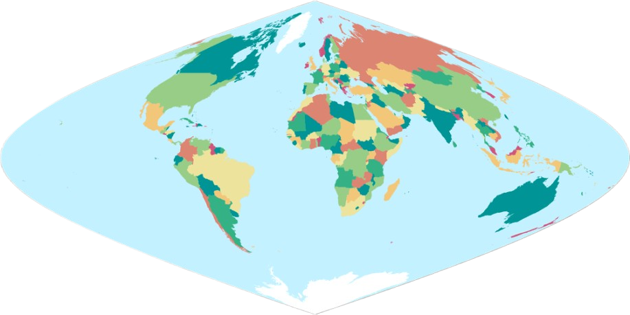
Putnins P6 Projection
Putnins P6 Projection is a pseudoconic equal-area projection proposed by Soviet geographer A. Putnins in the mid-20th century. Designed specifically for world maps, it aims to accurately preserve the area relationships between land and ocean. In this projection, the Earth’s graticule is projected onto a conical surface and then unfolded into a plane, resulting in meridians represented by straight lines radiating from a common vertex and parallels as concentric circular arcs centered at that vertex. Distortion is minimized near the standard parallels and increases with distance from them, yet area distortion remains zero throughout.
2026-03-26 18:36:15
MapLibre Services
MapLibre Services (MapLibre GL + self-hosted service ecosystem) is a geospatial service platform built around MapLibre GL, an open-source map rendering library. Originally derived from the open-source version of Mapbox GL JS, this project enables high-speed vector map rendering, custom style display, and the development of interactive mapping applications. MapLibre Services is characterized by its ability to operate functions such as tile delivery, style management, geocoding, and routing on self-managed servers, allowing for flexible map service construction while avoiding cloud dependency. This enables enterprises and research institutions to securely manage their own geospatial data while developing advanced web mapping applications.
2026-03-24 19:02:15