Service

TER (Terragen Terrain File)
Jan 22,2026
GISBox is a one-stop 3D GIS data editing, conversion and publishing platform that supports editing in multiple GIS formats such as OSGB/GEOTIFF/RVT, converting to 3DTiles/Terrain and publishing.
Introduction
TER (Terragen Terrain File) is a proprietary terrain data file format used by the natural terrain generation software Terragen. Primarily designed for storing elevation information (heightmaps), it aims to represent realistic landforms such as mountains, hills, and valleys with high precision. While the TER format has been widely used in terrain modeling and the CG/VFX fields for its emphasis on visual realism, it is often treated as a supplementary or conversion format in the GIS domain.

File Structure
TER (Terragen Terrain File) is a binary format that stores terrain-defining information within a single file, mainly consisting of the following elements:
- Header Information: Contains the file identifier, version information, data size, and other basic details to ensure the TER file is correctly loaded.
- Elevation Data (Heightfield): Stores terrain elevation values in a grid pattern. Each cell represents the height of a single point, forming the foundation for generating realistic terrain shapes within Terragen.
- Resolution and Scale Information: Defines the grid's row and column counts, as well as the overall width, depth, and height scales, determining the terrain size in virtual space.
- Endianness and Data Type Specification: Specifies the storage format of elevation values (integer or floating-point) and endianness to ensure compatibility across different environments.
Pros
- High-Precision Terrain Representation: TER is specialized for elevation data. Combined with Terragen's advanced terrain generation algorithms, it enables highly natural and realistic terrain expressions.
- Lightweight and Simple Structure: As it primarily focuses on height information, the file structure is relatively simple, keeping data sizes smaller compared to general-purpose 3D mesh formats at the same resolution.
- Compatibility with CG/VFX Fields: Widely used in industries such as film, gaming, and video production that require realistic natural landscapes, making it suitable for rendering purposes.
- Easy Conversion to Other Formats: Can be converted to raw height data or some GIS raster formats, allowing integration into different production or analysis pipelines.
Cons
- Dependence on Proprietary Software: TER is a proprietary format designed for Terragen and may not be directly supported by general GIS software or 3D modeling tools.
- Lack of Attribute Information: Cannot store attributes beyond elevation (e.g., land use, geology, textures), limiting its use to pure terrain shape data.
- Weak Geodetic and Coordinate System Concepts: Unlike GIS formats, it does not inherently include strict geographic coordinate systems or geodetic datums, requiring additional processing for alignment with real-world location data.
- Unsuitable for Large-Scale Analysis: While suitable for visualization and rendering, TER is less directly applicable to GIS analyses such as broad-area analysis or spatial statistics.
Application Scenario
TER (Terragen Terrain File) is primarily used in fields such as CG, VFX, and game production, where realistic natural terrain visualization is emphasized. It is suitable for generating mountainous landscapes or natural environmental backgrounds, as well as realistic terrain depiction in films and animations. When combined with Terragen's advanced rendering capabilities, it enables high-quality visual production. Additionally, TER is sometimes used to convert DEMs (Digital Elevation Models) created in GIS or remote sensing for visualization or presentation purposes. The format excels in applications prioritizing expressive power and realism over precise real-world surveying and analysis.
Example
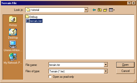
1. Example of a TER (Terragen Terrain File).
File Opening Mode
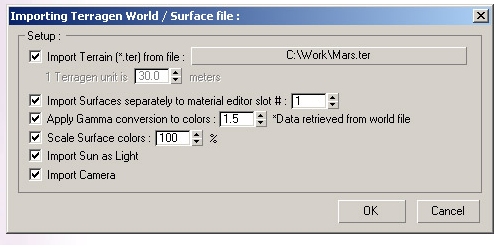
1. Import a Terragen world surface file.