 Service

Peirce Quincuncial Projection
Nov 5,2025
GISBox is a one-stop 3D GIS data editing, conversion and publishing platform that supports editing in multiple GIS formats such as OSGB/GEOTIFF/RVT, converting to 3DTiles/Terrain and publishing.
Introduction
Peirce Quincuncial projection is a conformal map projection that presents the globe as a square frame, with the equator displayed as a rotated square centered on the North Pole. Its core characteristic is accurate local shape and orientation (conformal properties), but angular distortion occurs at the center of the four sides. The projection supports seamless tessellation, or mosaicking, allowing the construction of a continuous world route network by stitching together multiple tiles. This projection is particularly useful in aviation and maritime applications, where a coherent view of global navigation routes is required.
Projection Basic
The Peirce Quincuncial projection is centered on the North Pole and uses the Schwarz-Christoffels mapping in complex variable functions to conformally project the Earth's surface onto a square frame, maintaining accurate local shape and direction (except for the centers of the four sides of the square). It also supports the construction of a continuous global route network by seamlessly stitching multiple tiles. It is particularly suitable for scenarios such as aviation and maritime navigation and polar scientific research that require a balance between local accuracy and large-scale coverage.
Pros
- Conformal Properties (Locally Conformal): Except at the center of the four sides, the projection maintains constant angles, making it suitable for scenarios requiring precise direction or shape analysis (such as navigation and aviation).
- Tessellation and Mosaicing: Supports seamless tiling of multiple tiles to create a continuous global route network or polar expedition route planning map, particularly suitable for scenarios requiring coverage of large areas while maintaining local accuracy.
- Advantages for Polar Region Display: When centered on the North Pole or South Pole, the relative position of the polar regions in relation to other continents can be clearly presented. For example, when planning Antarctic expedition routes, the connection between Antarctica and the surrounding oceans can be fully demonstrated.
- Visual Uniqueness: The square frame and rotated equatorial design provide a different perspective on the Earth than traditional projections such as Mercator, making it a useful supplementary tool for teaching or presentations.
Cons
- Severe Area Distortion: Area distortion increases from the center of the square outward, with distortion being particularly pronounced at the midpoints of the four sides. This makes it unsuitable for scenarios requiring precise area calculations (such as land surveying and resource distribution analysis).
- Directional Distortion: Although it is a conformal projection, the overall orientation is not true, which can mislead the interpretation of global orientation.
- Complex Meridians: Except for the 90 meridians at the poles, which are straight lines, all other meridians are complex curves, increasing the difficulty of map drawing and the reading threshold.
- Ocean Shape Distortion: The natural shapes of the oceans are not fully represented, which can affect the understanding of the geographical relationships of the oceans.
Application Scenario
The Pierce Quincunx projection is suitable for scenarios that require seamless stitching of global route maps or display of geographic information in high-latitude areas, such as aviation and navigation.
Example
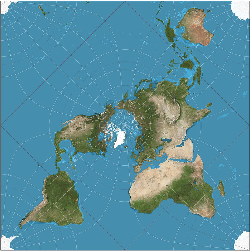
1. Peirce quincuncial projection of the world. The red equator is a square whose corners are the only four points on the map at which the projection fails to be conformal.
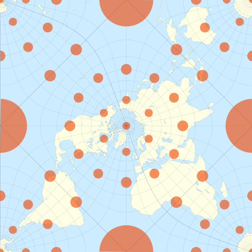
2. The Peirce quincuncial projection with Tissot's indicatrix of deformation.
Related GIS Projections
Longitude / Latitude Projection