Service

USG SDEM (United States Geological Survey Digital Elevation Model)
Nov 5,2025
GISBox is a one-stop 3D GIS data editing, conversion and publishing platform that supports editing in multiple GIS formats such as OSGB/GEOTIFF/RVT, converting to 3DTiles/Terrain and publishing.
Introduction
USGS DEM is an open DEM data format standard defined by the United States Geological Survey (USGS). It uses ASCII code for storage and consists of three logical records: A (file header), B (section data), and C (precision information). Each logical record unit is fixed at 1024 bytes. This format supports both UTM projection and geographic coordinate (seconds) grid types, and the data range covers a variety of geographic grid products, including 7.5 minutes, 30 minutes, and 1 degree. Its files can be directly read and converted to common raster formats using tools such as ArcGIS. The GDAL library natively supports parsing and can automatically identify coordinate systems and elevation units (meters/feet).

File Structure
The USGS DEM file structure can be divided into four main sections:
- File header: Contains the file identifier and version information, records the file creation and last modification dates, and stores basic information such as file size and number of records
- Metadata area: Contains georeferencing information (coordinate system, projection parameters), records elevation units (meters or feet), stores data accuracy and quality control information, and contains information about the data producer and source.
- Storage format: ASCII text, with fields defined at fixed byte positions (e.g., coordinates start at byte 110).
- Quality control area: Records data collection methods and accuracy assessments, contains data editing and validation information, and stores information about related reference documents.
Pros
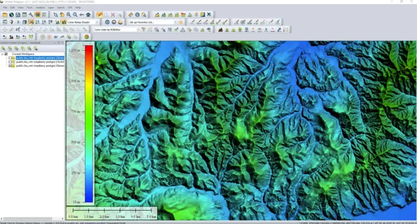
- High Precision and High Resolution: 12.5m resolution data provides detailed descriptions of surface morphology, with vertical accuracy up to 6 meters and horizontal accuracy up to 16 meters.
- Global Coverage: Provides DEM data for global land and ocean areas, supporting multi-domain applications.
- Strong Format Compatibility: Provided in standard formats such as GeoTIFF, it can be used directly in mainstream GIS software.
- Enhanced Browsing Mode: Implements an elevation-based browsing mode, which determines the movement step size based on the user's current viewpoint elevation, avoiding the drawbacks of fixed movement steps and greatly facilitating user control of the entire scene.
- Data Integrity: Includes metadata and quality control information, supporting professional applications such as terrain analysis and flood simulation.
Cons
- Data redundancy: Regular grid structures produce redundant data in flat areas, resulting in low storage efficiency.
- Limitations in terrain representation: Fixed grids may not accurately represent key terrain features such as peaks and ridges.
- Large data volume: High resolution results in large single file sizes, placing high demands on storage and transmission.
- Lack of dynamic adaptability: Fixed grids struggle to adapt to terrain with varying degrees of undulation.
Application Scenario
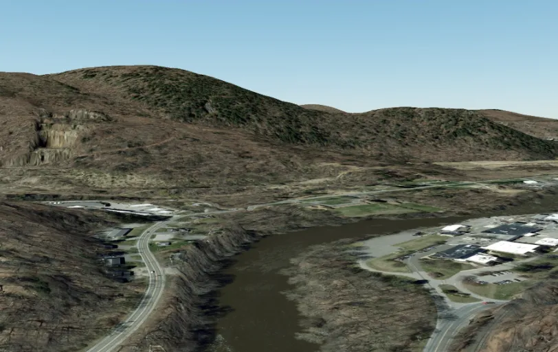
USGS DEM (United States Geological Survey DEM format) is widely used in terrain analysis, hydrological modeling, disaster assessment, urban planning, environmental monitoring, military defense, and 3D visualization. For example, it is used to calculate flow paths and flooded areas in flood simulations, assist in earthwork calculations and line-of-sight analysis in engineering construction, and can also be combined with satellite imagery to generate 3D terrain models for game development. Its high-precision data (such as 12.5-meter resolution) is particularly suitable for scenarios requiring detailed terrain features.
Example
- The US 1-meter DEM terrain tile data is shared free of charge.
File Opening Mode
- Use GIS software to load dem.