Service

CH1903 / LV03 (Old Swiss National Coordinate System – EPSG:21781)
Nov 5,2025
GISBox is a one-stop 3D GIS data editing, conversion and publishing platform that supports editing in multiple GIS formats such as OSGB/GEOTIFF/RVT, converting to 3DTiles/Terrain and publishing.
Introduction
CH1903/LV03 is the national Cartesian coordinate system used by Switzerland. It uses the former Bern Observatory as its reference point (mandatory definition: 600,000 meters east longitude, 200,000 meters north latitude) and uses metric units to simplify positioning calculations. This coordinate system is based on the CH1903 geodetic datum. Its improved version, CH1903+, relocates the reference point to the Zimmerwald Observatory, but the coordinate error between the two is kept within 3 meters, making it suitable for mapping services throughout Switzerland. Unlike globally accepted geographic coordinate systems such as WGS84, CH1903 is a projected coordinate system that uses Cartesian (X, Y) coordinates to enable precise measurement of local areas.
Coordinate System Composition
- Datum and Origin: This coordinate system forcibly defines the WGS84 coordinates of the former Bern Observatory in Switzerland (46°57'3.9"N, 7°26'19.1"E) as the coordinate origin (600,000m E, 200,000m N), simplifying calculations using metric units. The improved version CH1903+ relocates the datum to the Zimmerwald Observatory, but the coordinate error between the two is kept within 3 meters.
- Projection Method: The Oblique Mercator projection is used to convert the Earth's ellipsoid (based on the 1841 Bessel ellipsoid) into rectangular coordinates, ensuring that coordinate values throughout Switzerland are positive and that east longitude (X-axis) is always greater than north latitude (Y-axis).
- Coordinate Axes: The positive direction of the X-axis is east, corresponding to longitude; the positive direction of the Y-axis is north, corresponding to latitude. Technical standards and specifications: Designed specifically for Switzerland and Liechtenstein, EPSG code is 21781.
Pros
- Metric units simplify calculations: Using rectangular coordinates (X, Y) and metric units facilitates practical applications in Switzerland, such as engineering surveying and cartography, and avoids the complexity of longitude and latitude conversion.
- High local accuracy: Based on the Oblique Mercator projection, optimized for small areas of Switzerland, ensuring plane coordinate accuracy, with an error limit of less than 3 meters.
- Positive coordinate values: A mandatory origin (600,000m E, 200,000m N) ensures positive coordinate values throughout Switzerland, avoiding calculation difficulties caused by negative values.
- Compatible with WGS84: Conversion to the universal global coordinate system WGS84 can be performed using mathematical formulas or dedicated libraries (such as WGS84_CH1903), facilitating data exchange.
Cons
- Applicable only to Switzerland and Liechtenstein: As a national coordinate system, its projection parameters and datum are designed specifically for Switzerland and are not applicable globally or elsewhere.
- Projection distortion is inevitable: Any projection distorts shapes, areas, or distances. Therefore, CH1903/LV03 is significantly less accurate when used outside Switzerland.
- Differences from commonly used global coordinate systems: Additional conversions are required to be compatible with international standards such as WGS84, increasing data processing complexity.
- Impact of datum point migration: The improved CH1903+ version relocates the datum point from Bern to Zimmerwald. While this error is manageable, considerations should be taken regarding compatibility with historical data.
Application Scenario
CH1903/LV03 is primarily used in land surveying, engineering surveying, and map production in Switzerland and Liechtenstein. Its metric (X, Y) units simplify local distance calculations, making it particularly suitable for small-scale, high-precision applications. This coordinate system is widely used in scenarios such as smart cities, land management, and infrastructure planning, for example, supporting urban digitalization through real-world 3D modeling. Because it uses the Oblique Mercator projection, its plane coordinates exhibit minimal distortion within Switzerland. However, considerations must be taken when converting to global coordinate systems such as WGS84.
Example
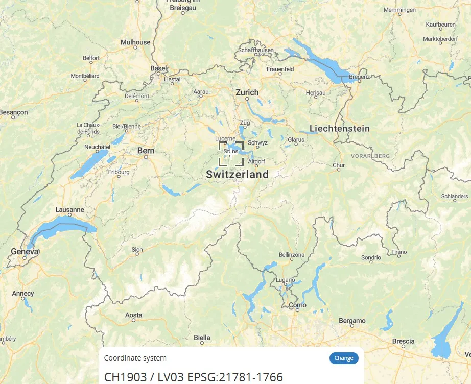
1. Swiss coordinate system - EPSG:21781.
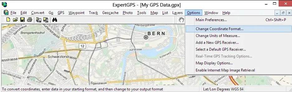
2. ExpertGPS converts Swiss coordinates.