Service

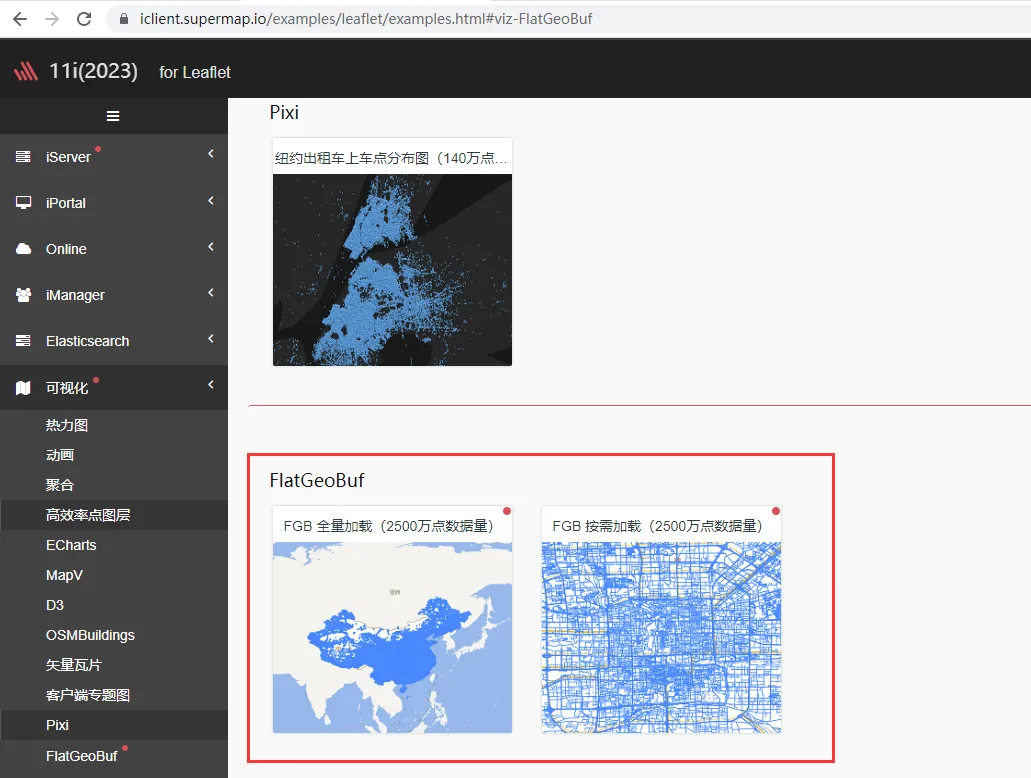
FlatGeobuf
Nov 5,2025
GISBox is a one-stop 3D GIS data editing, conversion and publishing platform that supports editing in multiple GIS formats such as OSGB/GEOTIFF/RVT, converting to 3DTiles/Terrain and publishing.
Introduction
FlatGeobuf is a high-performance binary-encoded vector geographic data format designed for processing large-scale static geographic data. It utilizes FlatBuffers technology for compact storage and fast read/write speeds. It features a built-in Packed Hilbert R-Tree spatial index and supports streaming and on-demand loading, significantly improving network transmission efficiency and rendering speed. It is particularly well-suited for scenarios requiring efficient processing of massive amounts of geospatial data. As an open-source format, FlatGeobuf is compatible with mainstream tools such as GDAL, QGIS, and GeoServer, and supports multi-language implementations, making it an ideal alternative to traditional Shapefiles and GeoJSON.
File Structure
- File header: Contains a Magic Number identifier (fixed at 0x6667620366676200), version information, feature geometry type definition, optional global spatial extent, and coordinate system reference information (such as EPSG code or WKT definition).
- Spatial index structure: Utilizes an optional Hilbert R-tree implementation with hierarchical node data storage, supporting efficient spatial range queries. The index granularity is adjustable to balance performance and storage efficiency.
- Feature data storage: FlatBuffers are used to store geometric data (compliant with the OGC Simple Features standard) and attribute data (supporting multiple data types), using a variable-length storage mechanism to optimize space utilization.
- Data chunking: Supports chunking by fixed size or logical grouping, recording chunk offsets for random access and facilitating parallel processing and streaming.
- Metadata system: Defines the attribute field structure (name/type/description, etc.) and supports user-defined extended metadata (such as timestamps, data source, and other additional information).
- File tail structure: records the storage location offset of the spatial index (if an index exists), and optionally includes data verification information (such as CRC32 checksum) to ensure file integrity.
Pros
- Extreme Performance: Read and write speeds significantly exceed those of traditional formats (2-5 times that of Shapefiles, 5-10 times that of GeoJSON), supporting streaming loading of terabyte-scale data; zero-copy memory mapping reduces I/O overhead; and Hilbert R-tree indexing accelerates spatial queries by 10-100 times.
- Ultra-High Storage Efficiency: Binary compression rates are 60%-80% higher than GeoJSON; a single file integrates geometry, attributes, and indexes; and 8-byte coordinate alignment optimizes CPU cache utilization.
- Adaptation to Modern Technologies: WebAssembly enables browser parsing; native support for GDAL/QGIS, based on the FlatBuffers framework, is compatible with cloud-native architectures, and is commercially available under the MIT license.
- Expandability: Reserved fields support future evolution (such as 3D coordinates and spatiotemporal data); and a block-based mechanism enables random access and parallel processing.
Cons
- Functionality Deficiencies: No support for transactions or concurrent writes; no ability to store topological relationships; no built-in B-tree indexes for attribute queries.
- Ecosystem Shortcomings: Debugging requires specialized tools (such as fgbview); community resources are limited to mature formats; and new versions may have compatibility risks.
- Scenario Limitations: Suitable only for publishing static data (such as offline map packages). GeoPackage should be used for frequent editing scenarios. Cost-effectiveness is low for small datasets; GeoJSON is preferred for lightweight web presentations.
Application Scenario
With its high-performance binary characteristics, FlatGeobuf is particularly suitable for scenarios that require efficient processing of large-scale static geographic data: it can be used as the backend data storage for high-concurrency WebGIS services, enabling fast spatial queries and streaming transmission; it supports lightweight storage of offline map packages on mobile devices, reducing storage usage and loading delays; it is suitable for the publication and sharing of national basic geographic information data (such as road networks and POIs), improving data access efficiency; it is also suitable for areas such as real-time traffic and environmental monitoring that require rapid updates but do not require frequent editing, balancing performance and storage costs.
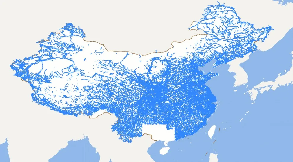
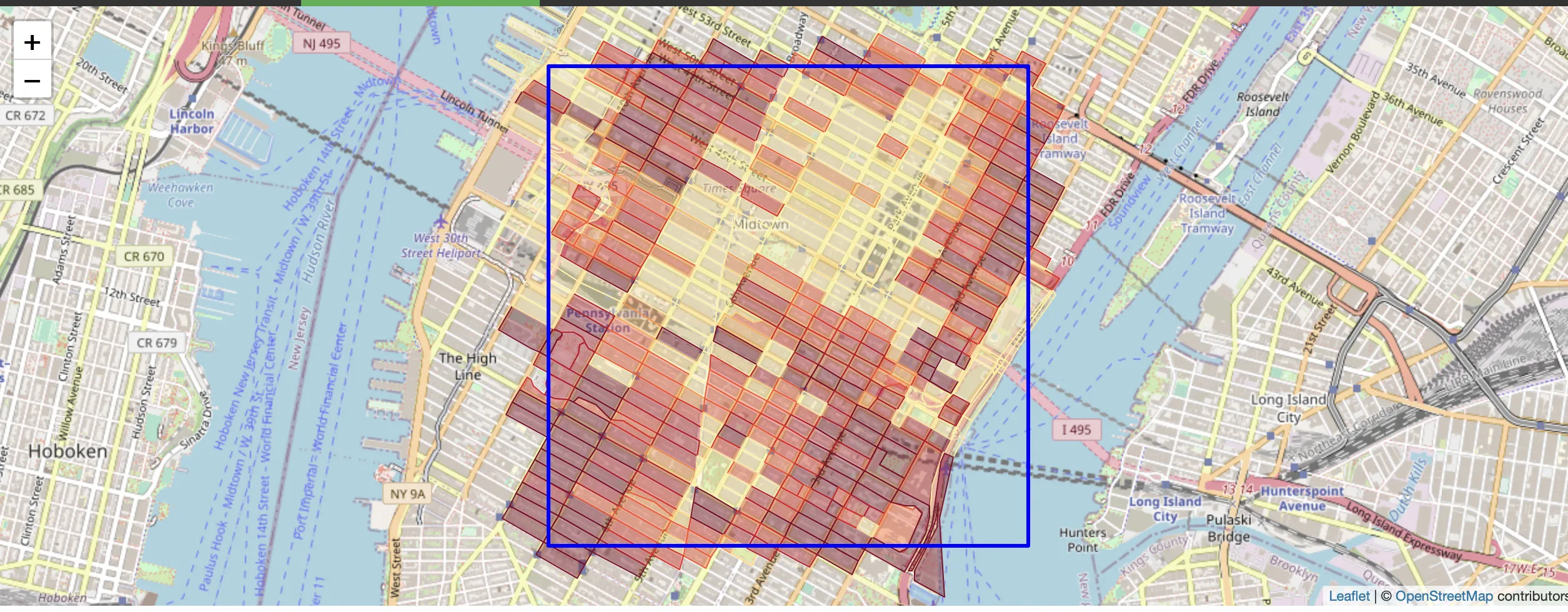
Example
1. The effect of fully loading FlatGeoBuf 25 million points of data.
2. Flatgeobuf census blocks slippery map demo.
File Opening Mode
- The FlatGeoBuf format file returned by the SuperMap iServer11.1 service.