 Service

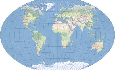
Winkel Tripel Projection
Nov 5,2025
GISBox is a one-stop 3D GIS data editing, conversion and publishing platform that supports editing in multiple GIS formats such as OSGB/GEOTIFF/RVT, converting to 3DTiles/Terrain and publishing.
Introduction
Winkel Tripel Projection is a map projection developed with the goal of projecting geographic information as balanced as possible on a map. It was invented by German geographer Oswald Winkel in 1921 and is a combination of the Equirectangular Projection and the Aitoff Projection. The name "Tripel" comes from the fact that distortions of latitude and longitude, area, and distance are kept to a "triple" level. It is used in many countries' atlases and educational materials to achieve a balanced appearance when displaying world maps.
Projection Basic
The Winkel Tripel projection is created using the following mathematical formulas:
- It adopts the Aitoff projection (a modification of the azimuthal equidistant projection) in the longitudinal direction, and
- Blends elements of the orthographic projection in the latitudinal direction, averaging the two.
This hybrid approach makes it possible to avoid extreme distortions while maintaining a visually balanced appearance. The entire map fits within a smooth elliptical shape, featuring the following characteristics:
- It minimizes overall distortion, enabling a visually natural representation of the Earth.
- It reduces distortion in high-latitude regions (especially polar areas) while preventing significant distortion near the equator.
- Areas positioned near the center of the map (often Europe or Africa) are displayed with greater accuracy.
Pros
- Well-balanced distortion: It avoids extreme distortions in distance, area, and shape, providing an overall excellent visual balance.
- Natural appearance, ideal for educational purposes: Since it does not overly emphasize any specific region, it is well-suited for fair and neutral world maps.
- Widely adopted and highly reliable: It is used by many global mapping institutions, including National Geographic magazine, indicating its high reliability.
- Easy to set the center: By adjusting the projection center, any region can be placed at the center of the map.
Cons
- Mathematically complex: Compared to other simple projection methods (such as the Mercator projection), its calculation formulas are somewhat complex, imposing a higher computational load during programming and rendering.
- Unsuitable for surveying or navigation: As it cannot accurately preserve distances or angles, it is not practical for real-world navigation or surveying purposes.
- Not distortion-free: While it offers good balance, it is a compromise method that does not fully preserve any single attribute (area, angle, or distance).
Application Scenario
The Winkel Triathlon projection is primarily used in educational maps, encyclopedias, atlases, and world affairs maps, and is ideal for "bird's-eye views of the world." It is also widely used in publishing, printing, and posters, where map appearance and visual balance are important. This projection is also sometimes used by governments and international organizations for geographical materials, as well as web mapping services, especially when "displaying the Earth from a neutral perspective" is required. In GIS (geographic information systems), it is well-suited for displaying maps for visual presentations and international data comparisons.
Example
1. The Winkel III map projection centered on Greenwich is shown.
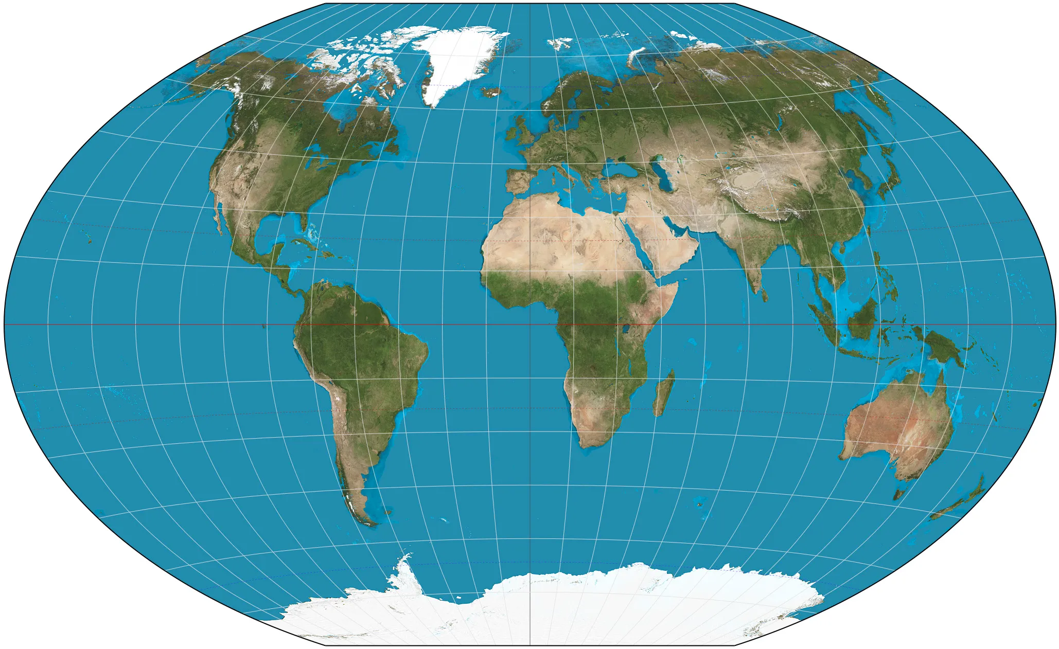
2. Winkel trigonometric projection of the world, 15th degree graticule.
Related GIS Projections
Transverse Mercator Projection
Longitude / Latitude Projection