 Service

Quartic Authalic Projection
Jan 26,2026
GISBox is a one-stop 3D GIS data editing, conversion and publishing platform that supports editing in multiple GIS formats such as OSGB/GEOTIFF/RVT, converting to 3DTiles/Terrain and publishing.
Introduction
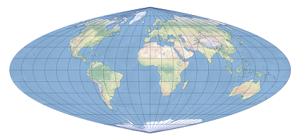
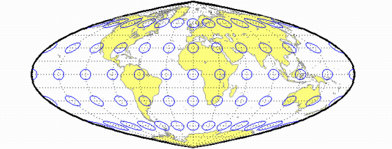
Quartic Authalic Projection is a pseudocylindrical equal-area projection independently developed by Karl Siemon in 1937 and Oscar S. Adams in 1945. It is derived by modifying the Lambert azimuthal equal-area projection, featuring a straight central meridian approximately 0.45 times the length of the equator, with other meridians represented as fourth-order algebraic curves and parallels as straight lines perpendicular to the central meridian. The poles are depicted as points. While significant shape distortion occurs along the edges due to excessive convexity of the meridians, the scale remains accurate along the equator and any given latitude, making it suitable for thematic world maps requiring precise area preservation.
Projection Basic
The Quartic Authalic Projection is built on the following mathematical and cartographic principles:
- Projection Type: Polynomial equal‑area projection
- Mathematical Basis: Uses a quartic polynomial function to transform spherical coordinates, ensuring that the area proportion of any region after projection strictly matches its true area on the Earth
- Coordinate Formulas: Constructs planar x, y coordinates based on longitude λ and latitude φ, satisfying the differential area‑preserving condition dA = R² cos φ dφ dλ = dx dy
- Symmetry: Typically symmetric about the central meridian, with parallels projected as families of curves
- Applicable Range: Global‑scale maps, with particular emphasis on shape optimization in mid‑ to low‑latitude regions
Pros
- Strict Global Equal‑Area Property: Guarantees accurate area proportions for any region after projection, making it suitable for statistical mapping of population, resources, etc.
- Improved Shape Representation in Polar Regions: Significantly reduces extreme stretching and compression distortions in polar areas compared to the Mollweide projection
- Concise Mathematical Expression: The quartic polynomial form facilitates computer implementation and batch coordinate conversion
- Strong Suitability for Thematic Maps: Provides a reliable spatial reference for global‑scale contour mapping, such as climate distribution and biodiversity
- Academic Research Value: Demonstrates the innovative potential of high‑order polynomials in balancing equal‑area properties and shape fidelity
Cons
- Noticeable Shape Distortion Persists: Although superior to traditional equal‑area projections, visible angular and length distortions still occur in mid‑ to high‑latitude regions, especially near the edges of the map
- High Computational Complexity: Compared to first‑ or second‑order transformations, quartic polynomial calculations require significantly more processing
- Limited Support in Standard GIS Software: Mainstream GIS software (e.g., ArcGIS, QGIS) does not include this projection by default, requiring custom parameters or programming for implementation
- Unsuitable for Large‑Scale Mapping: The global equal‑area design causes severe distortions in direction and distance at local scales, making it inappropriate for detailed regional planning
- High Cognitive Load for Map Readers: Non‑traditional graticule styles may reduce map interpretation efficiency for general audiences
Application Scenario
The Quartic Authalic Projection is primarily used in the creation of global‑scale equal‑area thematic maps, especially in fields requiring precise area comparisons, such as international development studies, climate change analysis, and natural resource assessment. For example: the United Nations Development Programme (UNDP) could use this projection to map per‑capita resource availability across countries; the International Union for Conservation of Nature (IUCN) could employ it to display the area distribution of global biodiversity hotspots; and climate research institutions might apply it to illustrate trends in polar ice‑sheet area changes. Additionally, this projection holds significant value in education and scientific research. It is often used in advanced cartography courses to demonstrate the optimization principles of polynomial projections and serves as an equal‑area foundational framework for global spatial statistical models.
Example
1. The quartic authalic projection is shown here centered on Greenwich.
2. Quartic Authalic Projection.
Related GIS Projections
Vertical Near-side Perspective Projection
Two-point Equidistant Projection