 Service

Hotine Projection
Nov 5,2025
GISBox is a one-stop 3D GIS data editing, conversion and publishing platform that supports editing in multiple GIS formats such as OSGB/GEOTIFF/RVT, converting to 3DTiles/Terrain and publishing.
Introduction
Hotine projection, also known as a specific implementation of the Oblique Mercator projection, is a conformal map projection developed and popularized by British geodesist Martin Hotine in the mid-20th century for his geodetic work in British colonies, primarily in the Malay Peninsula.
Projection Basic
The Hotine projection maintains the authenticity of local shapes and angles near the projection centerline by rotating a cylindrical surface obliquely (so that the axis is oblique to the Earth's rotation axis) combined with a conformal transformation. At the same time, it flexibly adapts to the precise mapping needs of obliquely extended areas through parametric design (azimuth, center point, etc.).
Pros
- High fidelity in mid-latitude regions: Minimal distortion in shape, area, and scale near standard parallels (e.g., 45°N/S), making it ideal for displaying geographic information in mid-latitude areas (e.g., Europe, North America, China).
- Balanced global distortion: Compared to other cylindrical projections (e.g., Mercator), it offers milder stretching at the poles and compression at the equator, resulting in more visually proportional global maps.
- Intuitive and easy to read: Straight, perpendicular meridians and parallels align with human perception, facilitating direction judgment and distance estimation.
- Historical and practical value: Widely used in British atlases, it remains suitable for educational purposes, world maps, and general reference applications.
Cons
- Significant distortion at high latitudes: Severe shape and area distortion near the poles (e.g., Greenland appears overly large), limiting its use for polar research or high-latitude navigation.
- Neither equal-area nor conformal: Fails to preserve both area and angle simultaneously, restricting its utility in precise measurements (e.g., land planning) or navigation (e.g., maritime charts).
- Limited versatility: Less adaptable than specialized projections (e.g., Lambert Conformal Conic for aviation, Albers Equal-Area for statistics) for targeted applications.
- Competition from modern alternatives: The rise of digital mapping and dynamic projections (e.g., adaptive Mercator) partially addresses its fixed-perspective limitations.
Application Scenario
Due to its conformal characteristics and flexible oblique axis design, the Hotine projection is particularly suitable for obliquely extending geographical areas (such as mid-latitude oblique archipelagos, mountain ranges, or long-distance linear engineering corridors), thematic mapping that requires accurate preservation of local shape and direction information (such as geological exploration and military combat maps), and navigation scenarios that rely on compass bearings. It can minimize distortion in oblique areas and ensure directional accuracy, but it is not suitable for large-scale or global mapping.
Example
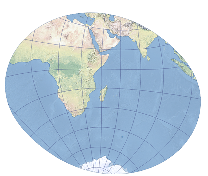
1. The Laborde oblique Mercator projection centered on Madagascar is shown.
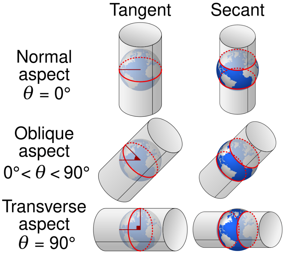
2. Comparison of tangent and secant forms of normal, oblique and transverse Mercator projections with standard parallels in red.
Related GIS Projections
Transverse Mercator Projection
Longitude / Latitude Projection