Service

VRML (Virtual Reality Modeling Language)
Sep 16,2025
GISBox is a one-stop 3D GIS data editing, conversion and publishing platform that supports editing in multiple GIS formats such as OSGB/GEOTIFF/RVT, converting to 3DTiles/Terrain and publishing.
Introduction
VRML is the abbreviation of Virtual Reality Modeling Language. It was created mainly to solve the problem of realizing 3D animation effects and user interaction based on 3D objects in web pages. VRML files are usually used to describe 3D virtual environments, containing information such as vertices, edges, and colors of polygons. Using VRML, developers can create interactive 3D scenes that can be displayed on web pages. VRML files use the extension .wrl (world file) and are stored in text format, which has good readability and is easy to edit manually.

File Structure
VRML (Virtual Reality Modeling Language) files consist of several key components, as follows:
1. File Header
Each VRML file starts with a special file header that indicates the file version.
2. Node
Node is the basic unit that makes up a VRML file. Each node can represent different geometric shapes, attributes, or behaviors.
3. Field
Provides summary information of the entity (type, attributes, hierarchy information, etc.).
4. Parameter Data Section
Field is the attribute of the node, which is used to describe the state of the node, such as color, position, material, etc.
5. Scene Graph
VRML uses scene graphs to represent all objects and their properties in the scene.
Pros
- **Cross-platform: **RML file is a text format that is platform-independent and can run on different operating systems and devices.
- **Powerful modeling capabilities: **VRML can create complex 3D scenes, including geometric shapes, textures, lighting effects, etc., providing users with a rich visual experience.
- **High interactivity: **VRML supports a variety of interactive methods, such as mouse, keyboard, touch screen, etc., through which users can interact with the virtual environment. .
- **Real-time rendering capabilities: **VRML can achieve smooth 3D rendering on low-performance hardware, providing users with a real-time, immersive virtual experience.
Cons
- Low computational efficiency: VRML is based on text format, and a large number of script instructions need to be processed in real time during parsing and rendering, which has high requirements for CPU and memory, and is prone to jamming in complex scenes.
- Insufficient hardware adaptation: Early VRML had limited support for graphics accelerators (such as GPUs), and could not fully utilize the parallel computing capabilities of modern hardware, resulting in slow rendering speed.
- Immature tool chain: At that time, there was a lack of efficient VRML editors and debugging tools. Modeling and scene building needed to rely on text editors, and the debugging process was cumbersome.
- Insufficient file size optimization: Although VRML files are small in size, they rely on external resources (such as textures and audio) and need to be downloaded separately, resulting in long loading times.
Application Scenario
VRML has been widely used in education (such as NASA solar system model, medical anatomy), engineering and construction (virtual house viewing, mechanical design), culture and art (digital museums, interactive art), commercial marketing (3D product display), military industry (simulation training) and other fields. Its core value is to achieve cross-platform 3D interaction at low cost, but due to performance, tool and ecological limitations, it has gradually been replaced by modern technologies such as WebGL/X3D.
Example
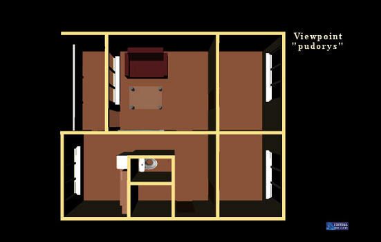
- Apartment ground plan in VRML.
File Opening Mode
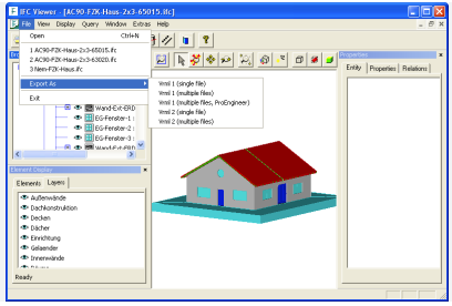
- IfcViewer VRML Export.