 Service

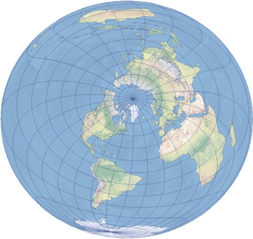
Two-point Equidistant Projection
Nov 5,2025
GISBox is a one-stop 3D GIS data editing, conversion and publishing platform that supports editing in multiple GIS formats such as OSGB/GEOTIFF/RVT, converting to 3DTiles/Terrain and publishing.
Introduction
The latitude and longitude network of a 2-point Equidistance Projection typically exhibits complex curves that do not maintain symmetry, with deformations in shape, area, and direction, but can preserve the true distance between two selected points and other points. The National Geographic Society of the United States once applied it to map Asia, while Bell Telephone System Company used an improved version to calculate long-distance telephone rates. The projection parameters include the east offset, north offset, and latitude and longitude coordinates of two points, and only support spherical models. Elliptical models cannot fully maintain equidistant properties. When two projection points coincide, the projection is transformed into an equidistant azimuthal projection.
Projection Basic
The longitude and latitude network with equidistant projection of two points usually exhibits complex curves that do not maintain symmetry, and have deformations in shape, area, and direction, but can preserve the true distance between two selected points and other points. The National Geographic Society of the United States once applied it to map Asia, while Bell Telephone System Company used an improved version to calculate long-distance telephone rates. The projection parameters include the east offset, north offset, and latitude and longitude coordinates of two points, and only support spherical models. Elliptical models cannot fully maintain equidistant properties. When two projection points coincide, the projection is transformed into an equidistant azimuthal projection.
Pros
1. Distance fidelity: The distance between any other point on the map and two reference points is consistent with the actual distance on the Earth's surface, suitable for scenarios where precise measurement of the relationship between two points is required.
2. Local deformation is controllable: If the angle between two reference points is within 45 °, the shape and area of the surrounding area will deform the least, which is suitable for highlighting the geographical relationship of a specific area.
3. Flexibility: By adjusting the position of the reference point, it can adapt to different needs (such as those used by the National Geographic Society for Asian maps).
Cons
1. Significant global deformation: After exceeding the 45 ° range of the two reference points, the deformation in shape, area, and direction increases sharply, making it unsuitable for large-scale maps.
2. Cannot represent the path of a large circle: A straight line starting from a certain point only represents the length of the large circle, not the actual path, which may mislead navigation or path planning.
3. Complex latitude and longitude network: The projected latitude and longitude network is an asymmetric curve, which increases the difficulty of mapping and visual interference.
Application Scenario
Two point equidistant projection is mainly used in scenarios where the distance relationship between two specific points needs to be highlighted. For example, the National Geographic Society used it to draw maps of Asia to emphasize regional geographic connections, while Bell Telephone Systems used an improved version to calculate long-distance phone rates. This projection is also applicable to local maps displaying the distance between the starting and ending points in navigation or aviation, but it should be noted that it only supports spherical models and the deformation becomes significant as the range expands.
Example
1. Two-point equidistant projections centered on Redlands, California, USA and Ljubljana, Slovenia.
2. A map of Asia with equidistant projections of two points.

Related GIS Projections
Transverse Mercator Projection
Longitude / Latitude Projection
References
- https://baike.baidu.com/item/%E4%B8%A4%E7%82%B9%E7%AD%89%E8%B7%9D%E6%8A%95%E5%BD%B1/15454186
- https://pro.arcgis.com/zh-cn/pro-app/latest/help/mapping/properties/two-point-equidistant.htm
- https://zhuanlan.zhihu.com/p/42064020