 Service

Bonne Modified Projection
Jan 23,2026
GISBox is a one-stop 3D GIS data editing, conversion and publishing platform that supports editing in multiple GIS formats such as OSGB/GEOTIFF/RVT, converting to 3DTiles/Terrain and publishing.
Introduction
Bonne Modified Projection is an equal-area pseudoconical projection method, an optimized variant of the classic Bonne projection. It preserves equal-area properties while improving shape distortion in peripheral regions. Originally proposed by the French cartographer Rigobert Bonne in the 18th century, this projection has undergone multiple mathematical refinements to meet modern cartographic needs. It is particularly suitable for mapping medium-scale regions at mid-latitudes. By parameterizing adjustments to the standard parallel and central meridian, the modified Bonne projection achieves a balance between equal-area accuracy, shape fidelity, and directional rationality, making it a common choice for thematic and regional planning maps.
Projection Basic
The modified Bonne projection is constructed based on the following mathematical and geometric principles:
- Projection Type: Equal-area pseudoconical projection
- Standard Parallel: A single standard parallel (typically the central latitude of the region) is selected where the projection exhibits no length distortion
- Central Meridian: Defined as a straight line serving as the axis of symmetry, with meridians distributed as symmetric curves
- Latitude Lines: All parallels are projected as concentric circular arcs, with their centers located along the extension of the central meridian
- Coordinate Calculation: Utilizes improved spherical or ellipsoidal coordinate transformation formulas with distortion control parameters
- Applicable Range: Optimal for regions within 30°–60° latitude and longitudinal spans not exceeding 60°
Pros
- Strict Preservation of Area Accuracy: Fully satisfies equal-area requirements, making it suitable for area comparisons and statistical mapping
- Optimized Shape Representation in Central Regions: Minimal shape distortion near the standard parallel, resulting in natural feature outlines
- Aesthetically Pleasing Symmetrical Layout: Concentric circular arcs for parallels and curved meridians create a harmonious composition, enhancing map readability
- Flexible Parameter Adjustment: Adaptable to different geographic regions by modifying the standard parallel and central meridian parameters
- Historical and Professional Recognition: Long-standing application tradition in thematic mapping, historical cartography, and regional planning
Cons
- Significant Peripheral Distortion: Areas far from the standard parallel and central meridian experience noticeable angular and shape distortion
- Unsuitable for Large-Scale Mapping: Distortion increases sharply when the longitudinal span exceeds 60°, making it inappropriate for continental or global maps
- Complex Projection Calculations: Requires more complex mathematical transformations compared to simple conic or cylindrical projections
- Limited Compatibility with Modern GIS: Most mainstream GIS software does not include it as a default projection, necessitating custom parameterization
- Weak Directional Perception: Significant directional deviations occur except along the central meridian, hindering orientation judgment
Application Scenario
The modified Bonne projection is primarily used for thematic maps and regional planning maps that require accurate area representation, particularly in fields such as natural resource management, population statistics, agricultural zoning, and administrative division mapping. It is suitable for medium-scale regional maps such as provincial or state-level maps within a country, watershed planning maps, and land-use thematic maps. In historical map reproduction and geographic education, this projection is often employed to demonstrate traditional cartographic techniques. Additionally, due to its unique aesthetic of circular arcs, the modified Bonne projection is frequently chosen for published and display maps that balance area accuracy with visual appeal. It is especially well-suited for depicting approximately circular regions or for the restoration of traditional maps with cultural significance.
Example
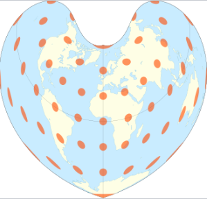
1. Bonne projection of the world, standard parallel at 45°N.

2. Bonne projection with Tissot's indicatrix of deformation.
Related GIS Projections
Vertical Near-side Perspective Projection
Two-point Equidistant Projection
References
- https://en.wikipedia.org/wiki/Bonne_projection
- https://pro.arcgis.com/en/pro-app/latest/help/mapping/properties/bonne.htm