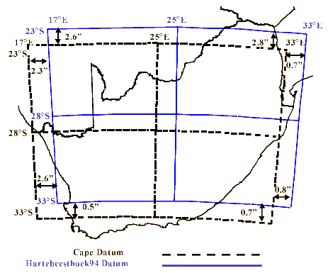
Hartebeesthoek94 (EPSG:4148)
Nov 5,2025
GISBox is a one-stop 3D GIS data editing, conversion and publishing platform that supports editing in multiple GIS formats such as OSGB/GEOTIFF/RVT, converting to 3DTiles/Terrain and publishing.
Introduction
Hartebeesthoek94 (EPSG:4148) is a geographic coordinate system covering all of South Africa and has been adopted as the country's national geodetic standard. This coordinate system is based on the International Terrestrial Reference Frame (ITRF), which uses the Earth's center of gravity, and was introduced in 1994. Its primary purpose is to obtain and use accurate location information within South Africa for purposes such as mapping, surveying, infrastructure management, and disaster prevention.
It is highly compatible with GNSS (particularly GPS) and provides positional accuracy that takes into account the effects of long-term crustal movement, making it also useful for geological surveys and wide-area surveys.
Coordinate System Composition
- Reference Coordinate System (Geodetic Datum): Hartebeesthoek94 (South African National Geodetic Datum based on the 1994 edition of the International Terrestrial Reference System (ITRF)).
- Projection Method: Normally used as longitude and latitude (geographic coordinate system), converted to UTM or a local plane coordinate system as needed.
- Center Longitude and Latitude: Approximately 25° South Latitude, 25° East Longitude (approximately the center of South Africa).
- Unit: Degrees (when displaying longitude and latitude).
- Coverage Area: All of South Africa and some areas of neighboring countries.
Pros
- High compatibility with GNSS (GPS) observation data ensures stable positioning accuracy.
- Compliance with the International Telecommunications Radio Frequency (ITRF) standard ensures long-term position consistency.
- Widely adopted as a national unified standard, ensuring high data compatibility in the surveying, GIS, and infrastructure fields.
Cons
- Its usefulness is limited outside of South Africa, and conversion is required for application to other regions.
- Long-term crustal movements and plate movements can result in discrepancies of several centimeters to tens of centimeters between the current geodetic frame and the current one.
- Support for certain older GIS and surveying software is limited, and conversion settings can be complicated.
Application Scenario
Hartebeesthoek94 (EPSG:4148) is used in all fields requiring accurate location information in South Africa, including surveying, mapping, urban planning, and infrastructure management. It plays an especially important role in the maintenance and management of public infrastructure such as roads, railways, and water and sewerage systems, resource exploration in the mining and energy sectors, and locating disaster sites. It is also used for crustal movement observation, geological research, and the development of a national control point network, making it a core coordinate system that supports South Africa's geographic information infrastructure.
Example
1. South African zero-order GPS network.
_1763977331628.png)
2. South African Gaussian coordinate system (Lo system).


 Service
