 Service

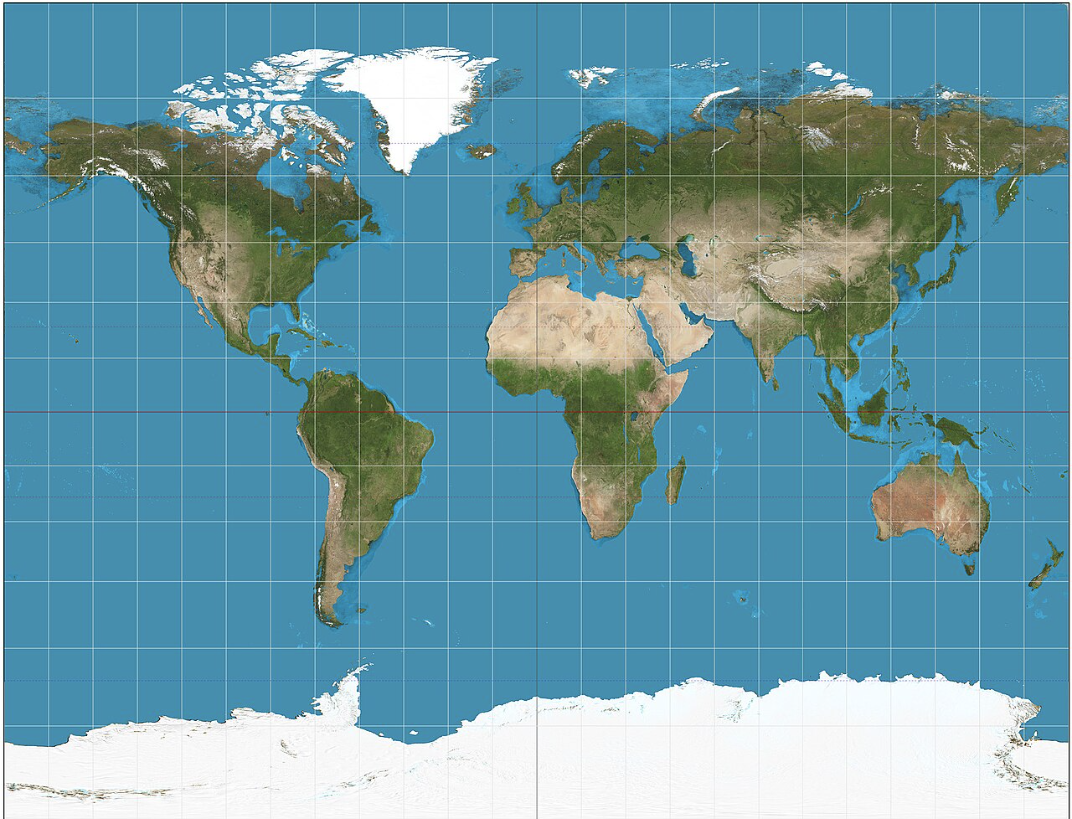
Gall Stereographic Projection
Nov 5,2025
GISBox is a one-stop 3D GIS data editing, conversion and publishing platform that supports editing in multiple GIS formats such as OSGB/GEOTIFF/RVT, converting to 3DTiles/Terrain and publishing.
Introduction
Gall stereographic projection is a cylindrical projection that projects the Earth's surface from a point opposite the equator onto a cylindrical surface, with the standard parallel fixed at 45 degrees. Its characteristics are parallel straight lines and equal-length curves of longitude. The scale is accurate along the standard parallels and remains constant between parallels equidistant from the equator. While it is neither equal-area nor equidistant nor conformal, it balances the scale of mid-latitudes, avoiding excessive stretching at the poles or compression at the equator, while maintaining high shape fidelity.
Projection Basic
The Gall Stereographic Projection is a secant cylindrical projection that intersects Earth at two standard parallels (typically 45°N/S). It uses perspective projection from an equatorial point onto a cylinder, preserving true scale along these parallels.
- Meridians: Straight, equally spaced lines.
- Parallels: Straight, evenly spaced lines (spacing increases away from the equator).
- Distortion: Minimal at 45°N/S; increases toward poles.
- Use Case: World maps prioritizing balanced mid-latitude representation (e.g., British atlases).
Pros
- High fidelity in mid-latitude regions: Minimal distortion in shape, area, and scale near standard parallels (e.g., 45°N/S), making it ideal for displaying geographic information in mid-latitude areas (e.g., Europe, North America, China).
- Balanced global distortion: Compared to other cylindrical projections (e.g., Mercator), it offers milder stretching at the poles and compression at the equator, resulting in more visually proportional global maps.
- Intuitive and easy to read: Straight, perpendicular meridians and parallels align with human perception, facilitating direction judgment and distance estimation.
- Historical and practical value: Widely used in British atlases, it remains suitable for educational purposes, world maps, and general reference applications.
Cons
- Significant distortion at high latitudes: Severe shape and area distortion near the poles (e.g., Greenland appears overly large), limiting its use for polar research or high-latitude navigation.
- Neither equal-area nor conformal: Fails to preserve both area and angle simultaneously, restricting its utility in precise measurements (e.g., land planning) or navigation (e.g., maritime charts).
- Limited versatility: Less adaptable than specialized projections (e.g., Lambert Conformal Conic for aviation, Albers Equal-Area for statistics) for targeted applications.
- Competition from modern alternatives: The rise of digital mapping and dynamic projections (e.g., adaptive Mercator) partially addresses its fixed-perspective limitations.
Application Scenario
The Gall Stereographic Projection is particularly well-suited for thematic map visualizations requiring global, equal-area attributes. Its core advantage lies in its ability to accurately maintain the proportional relationship between all regions, avoiding over-exaggeration of high-latitude areas (such as Greenland and Russia). This makes it ideal for presenting area-based data such as population distribution, resource reserves, and climate change indicators. It is widely used in social science research, education, and global comparative analysis of environmental policies, providing a geographic reference for objective spatial data comparisons.
Example
1. Gall stereographic projection of the world. 15° graticule.
2. Gall stereographic projection with 1,000 km indicatrices of distortion.

Related GIS Projections
Transverse Mercator Projection
Longitude / Latitude Projection