Service

OpenStreetCam
Nov 5,2025
GISBox is a one-stop 3D GIS data editing, conversion and publishing platform that supports editing in multiple GIS formats such as OSGB/GEOTIFF/RVT, converting to 3DTiles/Terrain and publishing.
Introduction
OpenStreetCam is an open-source map data collection project run by TeleNav, which collects street imagery and video data through crowdsourcing, contributing to improving the accuracy of OpenStreetMap. Meanwhile, the OpenStreetView API is an interface service provided by the OpenStreetMap project, designed to allow developers to access geographic data and integrate functions such as map display and geocoding. The relationship between the two is such that OpenStreetCam is responsible for data collection, and the results can be accessed and displayed through the OpenStreetView API.
File Structure
The OpenStreetCam/OpenStreetView API file structure mainly consists of the following core modules:
1. Data Collection Module:
Data is collected via a mobile app for iOS/Android platforms. It uses an ODB-II device to improve GPS positioning accuracy and automatically recognizes road signs using open-source machine learning algorithms. The image upload protocol complies with the CC-BY-SA license, allowing users to upload street photos and video metadata via an HTTP interface.
2. Data Processing Layer:
Structured metadata such as shooting time, location information, and device model are managed in JSON or XML format. Image data is compressed using Gzip or Brotli compression, and the compression method is identified by the Content-Encoding HTTP header.
3. Storage and Index:
A distributed file system is used, and original image files are stored in object storage such as S3. Each piece of data is identified by a unique hash value, and a geographic index based on the OpenStreetMap node/way model is built to enable fast range searches.
4. API Interface Specifications:
Complies with RESTful design and complies with the OpenAPI 3.1 standard. It defines endpoints such as upload and query and supports pagination and conditional filtering. The Accept-Version header manages API version compatibility.
5. Security and Authorization:
It uses the OAuth 2.0 authentication protocol to verify user permissions and prevent unauthorized access. It also provides a data revocation mechanism that allows users to delete uploaded content.
Pros
1. Open source and free: The website and mobile app are completely open source and anyone can use and modify them freely.
2. High-precision location: Support for ODB-II devices ensures high GPS accuracy even when used in a vehicle.
3. Smart recognition: Equipped with machine learning algorithms, it automatically recognizes road signs and other objects in real time as you take photos.
4. Flexible data management: Users can freely delete and manage their submitted data, providing easy privacy controls.
5. Strong community support: It is tightly integrated with the OpenStreetMap ecosystem, and photos can be viewed directly from the JOSM plugin and iD editor.
Cons
1. Delayed data updates: As data relies on user contributions, updates are slow and the latest information may be missing in some areas.
2. Limited coverage: Compared to commercial map services, coverage is limited, especially in developing countries.
3. Technical hurdles: Advanced use of the API requires a certain level of technical knowledge and programming skills.
Application Scenario
As core tools in the OpenStreetMap ecosystem, OpenStreetCam and the OpenStreetView API play an important role in the field of crowdsourced geographic data collection. OpenStreetCam specializes in collecting streetscape images, and its high-precision positioning and real-time sign recognition capabilities are used for traffic monitoring, autonomous driving testing, urban infrastructure management, and more. For example, streetscape data captured by mobile devices can be used to analyze changes in road signs and to assist in traffic accident investigations.
Example
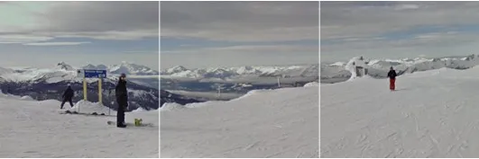
1. Image displayed after a successful response from a cityscape tile
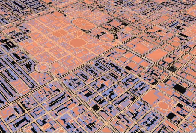
2. Urban street and building data obtained from OpenStreetMap.
File Opening Mode
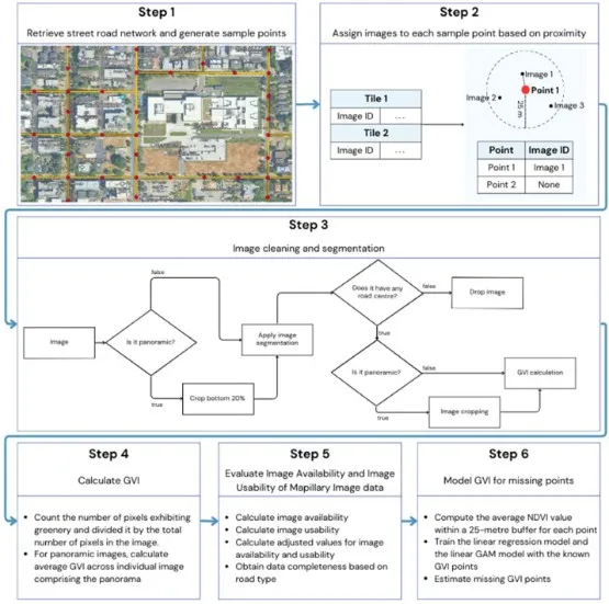
1. Search the street network and generate sampling points.