Service

Geocoding API
Nov 5,2025
GISBox is a one-stop 3D GIS data editing, conversion and publishing platform that supports editing in multiple GIS formats such as OSGB/GEOTIFF/RVT, converting to 3DTiles/Terrain and publishing.
Introduction
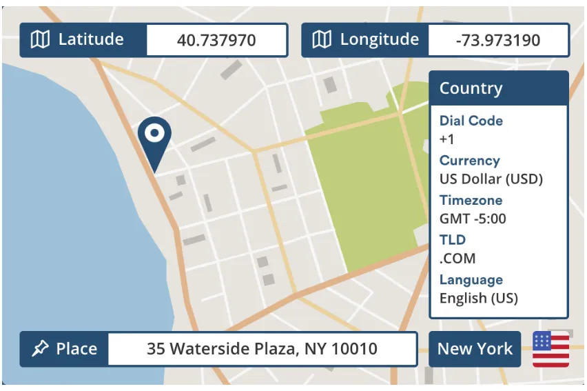
Geocoding API is a service for converting addresses into geographic coordinates (such as longitude and latitude) and converting geographic coordinates into human-readable addresses. It is widely used in map and location-related applications.
File Structure
As an HTTP interface, the Geocoding API itself involves a series of files and directory organizations related to API requests, responses, configurations, etc. during the calling and using process. The following is an example of a common project structure:
1. Source code directory
- API request related files: Store code files related to Geocoding API requests, such as request functions written in different languages (such as Python, JavaScript).
- Component files: Store component files related to address input and location display in front-end frameworks such as React.
2. Configuration file directory
- API key configuration file: Used to store configuration information such as API keys, such as apiKeys.js. In actual projects, API keys should be stored in environment variables to avoid hard coding.
3. Tool function directory
- Store tool functions or general logic, such as functions for encoding special characters.
4. Root component file
- The root component file of the project, such as App.js, is used to integrate various components and functions.
5. Static resource directory
- Store static resources of the project, such as images and fonts.
6. Project configuration file
- package.json: defines the project name, version, dependency library, script commands and other information.
- .gitignore: specifies files and directories ignored by Git.
- README.md: project description document, including project introduction, usage and other information.
7. Entry file
- The entry file of the project, such as index.js, is used to register the root component and start the application.
Pros
- Precise positioning and spatial mapping: quickly convert fuzzy or non-standardized addresses (such as "near Zhongguancun Building, Haidian District, Beijing") into standardized longitude and latitude coordinates, eliminate address ambiguity, and improve map matching and spatial analysis efficiency.
- Support LBS (location-based service) ecology: provide underlying positioning capabilities for scenarios such as navigation, food delivery, taxi-hailing, and social check-in, and support real-time path planning, regional recommendations, and nearby service retrieval.
- Cross-industry data integration: combine address data with GIS (geographic information system) to realize business values such as real estate valuation (coordinates associated with surrounding facilities), commercial site selection (thermal analysis of human traffic), and logistics optimization (distribution path planning).
- Improve automation efficiency: replace manual input of coordinates or manual error correction, reduce operating costs, and are especially suitable for batch address processing (such as e-commerce order address standardization and government address census).
Cons
- Insufficient address resolution accuracy: In complex urban environments, urban-rural fringe areas or newly developed areas, the address resolution accuracy of the map API may be less than 70%, resulting in positioning deviation or failure to return results.
- Dependence on network and API restrictions: Continuous Internet access is required to call services, and mainstream APIs (such as Google and Baidu) have a request limit for free users (such as 2,500 requests per day). If exceeded, payment is required or the request is blocked.
- Poor address format and semantic compatibility: The processing ability of non-standardized addresses (such as those containing ambiguous descriptions "near XX") or complex Chinese word segmentation (such as "No. 3 Jia" and "Block B") is weak, and it is easy to return wrong coordinates or empty results.
- Data update lag and regional differences: In some areas, due to changes in road planning or missing data, the geocoding results deviate greatly from the actual location, especially in developing countries or remote areas.
Application Scenario
The core application scenarios of Geocoding API (geocoding service) include: supporting map navigation, logistics route planning, location annotation (such as food delivery/taxi app positioning), real estate data analysis (such as the correlation between housing prices and geographic locations), emergency response (quickly locate the address for help), etc. by converting text addresses into precise latitude and longitude coordinates. At the same time, reverse geocoding (coordinate conversion to address) can be used for user location resolution (such as social check-in), regional business analysis (such as business district heat distribution) and IoT device location management, becoming the key technical foundation of LBS (location-based services).
Example
1. Build location verification capabilities using Google Maps Platform.
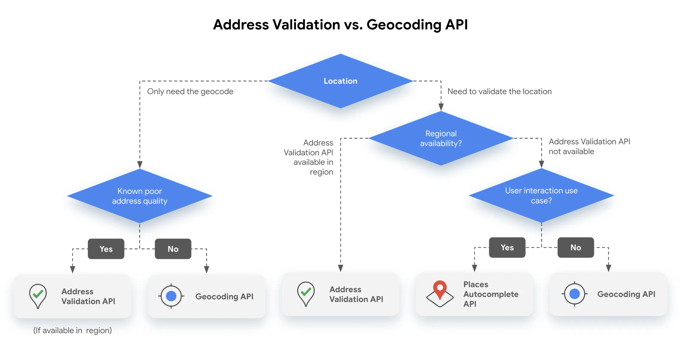
2. OpenStreetMap exports OSM data.
_1763976030881.png)
File Opening Mode
1. Google map api js call.