 Service

Berghaus Star AAG
Nov 5,2025
GISBox is a one-stop 3D GIS data editing, conversion and publishing platform that supports editing in multiple GIS formats such as OSGB/GEOTIFF/RVT, converting to 3DTiles/Terrain and publishing.
Introduction
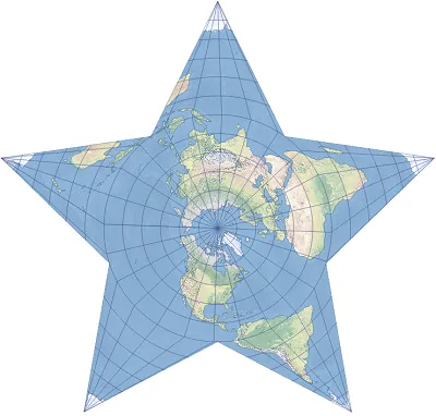
Berghaus Star Projection is a unique map projection that divides the entire surface of a globe into a star shape. It was invented in the 19th century by German geographer Hermann Berghaus and has been used primarily for decorative or educational purposes due to its beauty and unique composition. The variation used by the American Association of Geographers (AAG) in particular is known as an iconic design in geography.
Projection Basic
The Berghaus Star Projection divides the entire globe into 12 or 18 triangular or polygonal sections radiating from a central point and arranges them in a star-like pattern to unfold onto a flat plane. This method offers the following characteristics:
- Capable of displaying the entire Earth (a global projection).
- Maintains a visually balanced layout by arranging each section with nearly equal distance and area.
- Features a radial structure originating from a central point (typically the North Pole or a specific region), creating a strong visual impact and making it suitable for educational and exhibition purposes.
- While the continuity of latitude and longitude is compromised due to the division into multiple projection surfaces, it excels in preserving regional details.
Pros
- High artistic appeal and visibility: The star-shaped layout is highly eye-catching and enhances the decorative quality of the map.
- Minimal regional distortion: Distortion is relatively well-controlled within each radially segmented section.
- Strong for polar regions: Since the pole can be placed at the center, it is effective for analysis and education focused on polar areas.
- High educational value: Its visually memorable design makes it an excellent learning material.
Cons
- Lack of continuity: Since each triangular section is divided, the continuity of continents, meridians, and parallels is lost.
- Limited practicality: Not suitable for navigation, geodetic surveys, or precision GIS applications.
- Non-standardized: Few implementations exist in commercial software, restricting the available environments for use.
- Challenging for digital processing: The polyhedral structure complicates digital processing and coordinate transformations.
Application Scenario
Due to its visual beauty, the Berghaus star projection is often used as an educational map, an exhibition poster, and a symbolic visual for geography. It is also useful as a visualization tool for the Arctic and Antarctic regions, as it can represent maps centered on the polar regions. In recent years, it has also attracted attention as a method for visualizing geographic elements in art and infographics, and is widely used in publications, designs, academic journals, and more.
Example
1. Shown is the Berghaus star projection with parameters set to match the appearance of the Association of American Geographers (AAG) logo.
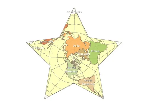
2. Berghaus star projection example.
Related GIS Projections
Transverse Mercator Projection
Longitude / Latitude Projection