 Service

GeoVRML
Nov 5,2025
GISBox is a one-stop 3D GIS data editing, conversion and publishing platform that supports editing in multiple GIS formats such as OSGB/GEOTIFF/RVT, converting to 3DTiles/Terrain and publishing.
Introduction
GeoVRML (Geographic Virtual Reality Modeling Language) is an extension of VRML (Virtual Reality Modeling Language) designed specifically for the 3D visualization of geospatial data. It uses standardized tags to describe terrain, coordinate systems, and geographic objects, enabling the sharing and interaction of 3D geographic scenes over the internet. It is commonly used for virtual simulation in fields such as Digital Earth and urban planning.

File Structure
The file structure of GeoVRML (Geographic Virtual Reality Modeling Language) is primarily based on and extends VRML:
- File Header: As an extension of VRML, GeoVRML files typically begin with a VRML header format, such as #VRML V2.0 utf8, which identifies the file type and encoding. The header is a required component of a GeoVRML file, ensuring that browsers can correctly interpret the file contents.
- Scene Graph Structure: The core of a GeoVRML file is the scene graph, composed of nodes that describe three-dimensional objects and their properties. The scene graph is organized in a hierarchical structure and includes node types such as geometric shapes, morphological attributes, light sources, and groups, supporting the three-dimensional representation of geospatial data.
- Event and Routing Mechanism: GeoVRML inherits VRML's event and routing mechanisms, enabling node interaction through event communication. Events are categorized as "incoming events" and "outgoing events," with routing defining the event propagation path, enabling dynamic interaction and responsiveness within geospatial data.
- Scripting and Prototype Extensions: GeoVRML supports the integration of Java or ECMAScript code through script nodes (e.g., Script) to implement custom behaviors. The prototype mechanism (PROTO) allows encapsulation and reuse of node types, supporting modular extension of geospatial modeling.
Pros
- Support for Multiple Coordinate Systems and Reference Ellipsoids: Comprehensive support for commonly used coordinate systems, such as geodetic and rectangular coordinate systems, eliminates VRML's limitation of supporting only local Cartesian coordinate systems.
- Improved Data Accuracy: All numeric types are represented using 64-bit double-precision data types (VRML uses 32-bit single-precision floating-point data types), ensuring millimeter-level accuracy. This eliminates issues such as data overlap and viewpoint jitter when representing and publishing geospatial data.
- Enhanced Support for Complex Geographic Models: With 10 nodes, including GeoCoordinate for describing the geographic coordinates of objects, GeoElevationGrid for building DTM models, and GeoLocation for accurately embedding standard VRML models into scenes, 3D visualization of geospatial data is simple and fast.
- Browse Mode Enhancements: An elevation-based browsing mode has been implemented, which determines the movement step size based on the user's current viewpoint elevation, avoiding the drawbacks of fixed movement steps and greatly facilitating user control of the entire scene. Open code and easy integration: The source code provided is open, making it easier to communicate and integrate with high-level programming languages (such as Java, C++, etc.).
Cons
- Limitations include: lack of consideration for time constraints, support for only independent static coordinate systems, roaming issues with large models, and lack of direct handling of corrections. These issues are expected to be addressed in subsequent versions.
- There are inherent VRML limitations: Because GeoVRML is based on VRML, it suffers from the inherent limitations of large data volumes and low efficiency. Furthermore, the introduction of new nodes and improved coordinate accuracy further increases the size of generated files, resulting in slower transmission speeds under current network conditions. However, as network conditions improve, this will no longer be a barrier to GeoVRML's development.
Application Scenario
GeoVRML is widely used in the field of three-dimensional visualization of geographic information, including virtual modeling in urban planning, natural resource monitoring (such as forest and marine environment analysis), military simulation training, digital display of cultural heritage, tourism VR experience development, and transportation and logistics path optimization. By combining high-precision geographic data with three-dimensional interactive technology, it improves the efficiency of spatial analysis and decision-making in various industries.
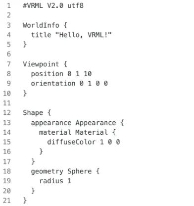
Example
- VRML is the basic syntax of the virtual reality language.
File Opening Mode
- Open GeoVRML in the browser.
_1763974176373.png)