 Service

General Perspective Projection
Feb 6,2026
GISBox is a one-stop 3D GIS data editing, conversion and publishing platform that supports editing in multiple GIS formats such as OSGB/GEOTIFF/RVT, converting to 3DTiles/Terrain and publishing.
Introduction
General Perspective Projection is a family of azimuthal map projections that simulate the view of the Earth from an arbitrary point in space, creating a perspective effect akin to a photograph taken from a distant observer. Unlike orthographic or stereographic projections which assume specific viewing distances or geometric relationships, this projection allows flexible positioning of the projection point—either above the Earth's surface (for satellite or aerial views) or at an infinite distance. It is particularly valuable for visualizing planetary bodies from space missions, generating realistic global and regional views, and supporting applications in astronomy, remote sensing, and scientific visualization where naturalistic perspective is prioritized over geometric preservation.
Projection Basic
The General Perspective Projection is constructed by projecting points from the Earth's spherical or ellipsoidal surface onto a tangent or secant plane, using a projection point at a defined distance from the Earth's center. Key parameters include:
- Projection point location (latitude/longitude of the point directly beneath the observer, known as the subpoint).
- Viewing height (distance from Earth's center to projection point).
- Viewing direction (typically nadir-directed, but may be tilted).Points are projected along straight lines connecting the projection point to the surface, creating a central perspective geometry where scale decreases radially from the subpoint. The projection may be tangent (plane touches Earth at subpoint) or secant (plane cuts through Earth), with the latter reducing extreme distortion near edges. Mathematical formulations involve spherical trigonometry or ellipsoidal ray‑tracing, with closed‑form solutions for spherical models and iterative methods for ellipsoidal implementations.
Pros
- Realistic Visual Representation: Produces images matching human or camera perspectives from space, making it ideal for public‑friendly global visualizations, planetarium displays, and mission planning graphics.
- Flexible Viewpoint Control: Supports adjustable observer heights—from low‑altitude aerial views to deep‑space perspectives—enabling customized visualization scales and fields of view.
- Intuitive Distortion Pattern: Distortion increases predictably from the center outward, with the visible hemisphere bounded by a limiting circle where rays become tangent to Earth, creating a natural horizon effect.
- Astronomical and Planetary Applicability: Extensible to other celestial bodies (Moon, Mars, etc.) by adjusting planetary radius and projection point, widely used in space mission imaging and planetary science.
Cons
- Non‑Conformal and Non‑Equal‑Area: Does not preserve angles, areas, or distances, limiting its use for precise measurements or quantitative geospatial analysis.
- Limited Coverage: Cannot represent more than one hemisphere (max 90° angular distance from subpoint), making it unsuitable for world maps or whole‑globe applications.
- High Edge Distortion: Extreme scale compression and shape distortion occur near the limiting circle, often rendering peripheral regions unrecognizable.
- Computational Intensity: Ellipsoidal implementations require iterative ray‑intersection calculations, increasing processing time compared to simpler azimuthal projections.
Application Scenario
The General Perspective Projection is primarily used to create realistic, observer‑centered visualizations of Earth and other celestial bodies from specific vantage points in space. It is widely employed in space mission planning and public outreach—for instance, generating simulated satellite views or spacecraft fly‑over animations that match actual orbital imagery. The projection also supports remote sensing training by emulating aerial and high‑altitude perspective geometry, aiding in the interpretation of sensor data. In interactive virtual globes and planetarium software, it enables dynamic “bird’s‑eye” and “global view” effects where users can adjust altitude and viewing direction in real time. Additionally, it serves atmospheric sciences and astronomy for illustrating phenomena such as solar eclipses, Earth’s limb, or planetary horizons as seen from a defined observation point. By merging cartographic principles with a naturalistic perspective, this projection turns abstract spatial data into visually intuitive and immersive representations.
Example
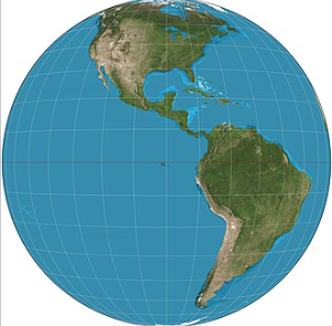
1. Vertical perspective from an altitude of 35,786 km over (0°, 90°W), corresponding to a view from geostationary orbit. 10° graticule.
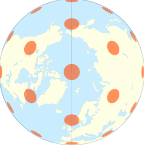
2. The vertical perspective projection showing exactly one third of the Earth's surface, with Tissot's indicatrix of deformation.
Related GIS Projections
Vertical Near-side Perspective Projection
Two-point Equidistant Projection