 Service

CNSDTF (China National Standard Geospatial Data Exchange Format)
Nov 5,2025
GISBox is a one-stop 3D GIS data editing, conversion and publishing platform that supports editing in multiple GIS formats such as OSGB/GEOTIFF/RVT, converting to 3DTiles/Terrain and publishing.
Introduction
CNSDTF (China National Standard Geospatial Data Exchange Format) is a national standard for geographic information system (GIS) data exchange in China. It unifies the storage and transmission formats of spatial data, such as vector and raster data, and addresses data compatibility issues across different platforms. Its core goal is to enable efficient cross-system sharing through structured file headers, feature parameters, and separated geometry/attribute data. It is widely used in fields such as land planning and environmental monitoring.
File Structure
The CNSDTF (China National Spatial Data Interchange Format) file structure is clear and consists of six main components:
- File Header: Contains basic file characteristics, such as the CNSDTF version identifier (DataMark), the current format version number (Version), and coordinate units (Unit). The header uses the character identifiers "HeadBegin" and "HeadEnd" to delimit its scope.
- Feature Type Parameters: Defines metadata such as the encoding, name, color, and attribute table for various spatial features.
- Attribute Data Structure: Specifies the format and type of attribute fields.
- Geometry Data: Contains specific geometric information about spatial features and is part of the graphical component of spatial vector data.
- Annotation: Textual information used to describe or annotate geographic entities, including the annotation's coordinate location, content, font, color, typeface, size, and other parameters.
- Attribute Data: Specific attribute information associated with geometry data and is the non-graphic attribute component of spatial vector data.
Pros
- Standardized Processing: As a standard format for geographic information system (GIS) data exchange, CNSDTF ensures seamless integration and sharing of spatial data between different systems, greatly facilitating cross-platform sharing and analysis of geospatial data and playing a significant role in advancing the development of geographic information science.
- Wide Coverage: CNSDTF focuses on the standardized processing of vector data, covering zero-dimensional, one-dimensional, and two-dimensional representations of spatial objects. It is suitable for a variety of application scenarios, including map production, land planning, and environmental monitoring.
- Flexible and Extensible File Header Structure: The file header is a core component of CNSDTF. It consists of an item name and item value, including information identifying the CNSDTF version, the current format version number, coordinate units, topological relationship identifiers, and coordinate system type. It can be expanded based on actual needs.
Cons
- Limitations in electronic map exchange: The current CNSDTF standard still has certain limitations and deficiencies in electronic map exchange, hindering its widespread application.
- Compatibility needs improvement: CNSDTF uses a large number of fixed-value methods in attribute data structures, such as RGB colors and font names. While this helps maintain data uniqueness, compatibility is significantly poorer.
Application Scenario
CNSDTF (China National Spatial Data Exchange Format), a standardized data exchange format for geographic information systems, is widely used in areas such as land surveying and mapping, urban planning, traffic management, and environmental monitoring. It efficiently integrates vector data from various sources and supports cross-platform sharing, providing a unified spatial data foundation for government departments, research institutions, and businesses. It plays a key role in collaborative analysis of multi-source data and the production of electronic maps.
Example
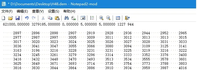
1. An extension patch for reading CNSDTF-DEM under ENVI.
2. CNSDTF data exchange format.
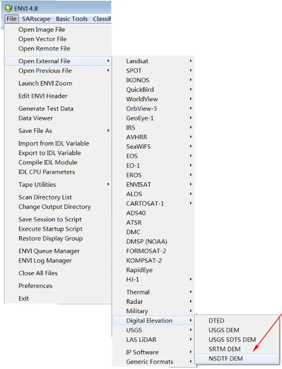
File Opening Mode
1. NSDTF-DEM Open Format.
Related GIS files
References
- https://en.verysource.com/item/cnsdtf_dem_read_rar-743044.html
- https://www.tandfonline.com/doi/pdf/10.1007/BF02826728
- https://link.springer.com/article/10.1007/BF02826728