 Service

DTED (Digital Terrain Elevation Data)
Nov 5,2025
GISBox is a one-stop 3D GIS data editing, conversion and publishing platform that supports editing in multiple GIS formats such as OSGB/GEOTIFF/RVT, converting to 3DTiles/Terrain and publishing.
Introduction
DTED (Digital Terrain Elevation Data) is a regularly gridded dataset representing Earth's surface elevation. Designed by the U.S. National Geological Information Service, it is widely used in fields such as military navigation and disaster response. The data is classified into different resolution levels (e.g., DTED0, DTED1, and DTED2), corresponding to resolutions of 900 meters, 90 meters, and 30 meters, respectively. The latest data may reach DTED3 (12 meters). File names are based on longitude and latitude (e.g., E000 for 0-1 degrees east longitude, N05 for 5-6 degrees north latitude), with the suffix indicating the level (e.g., .DT1 for DTED1).
File Structure
The DTED (Digital Terrain Elevation Data) file structure primarily includes the following core elements:
- Data level and resolution: DTED Level 0 (900-meter resolution), DTED Level 1 (90-meter resolution), DTED Level 2 (30-meter resolution), and DTED Level 3 (12-meter resolution).
- File naming convention: E000 (0-1 degrees east longitude) or W001 (0-1 degrees west longitude).
- Data storage structure: Elevation information is stored in "low latitude → high latitude" order, with the number of columns determined by the level and latitude range.
- Blocking and regional division: Different latitude ranges correspond to different numbers of columns (e.g., DTED Level 1 has 1201 columns for 0-50 degrees latitude and 201 columns for 80-90.1 degrees latitude).
Pros
- High Precision: Provides a regular grid structure (e.g., DTED Level 1 resolution of 90 meters, DTED Level 2 resolution of 30 meters), making it suitable for applications requiring precise elevation data, such as military navigation and disaster response.
- Wide Applicability: Supports terrain analysis (e.g., slope and aspect calculations), 3D visualization, and military applications (e.g., missile guidance and electronic sand table).
- Data Compatibility: Seamlessly integrates with GIS tools (e.g., ArcGIS and QGIS), supporting tile loading and dynamic updates.
Cons
- Data redundancy and storage requirements: Regular grid structures can lead to data redundancy in flat areas, resulting in low storage and transmission efficiency.
- Limitations in terrain feature representation: A fixed resolution may not accurately capture steep or complex terrain (such as peaks and fault lines), requiring additional feature data.
- Processing complexity: Large-scale DTED data (such as global coverage) requires high-performance computing resources and is challenging to process in real time.
Application Scenario
DTED (Digital Terrain Elevation Data) is widely used in military navigation, missile guidance, and electronic sand table simulations, providing precise terrain support for combat operations. In disaster management, it can be used for flood simulation, landslide risk assessment, and emergency response route planning. Combined with real-time drone monitoring, it improves rescue efficiency. Furthermore, DTED assists with route design and earthwork calculations in engineering surveys, and provides basic terrain data for GIS systems, supporting land use analysis and urban planning. Its standardized format also facilitates integration with remote sensing imagery (such as SRTM and ASTER GDEM) to enhance 3D visualization.
Example
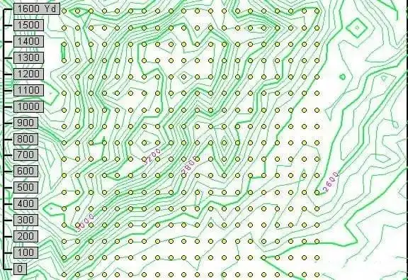
1. Schematic diagram of DTED (Digital Terrain Elevation Data).
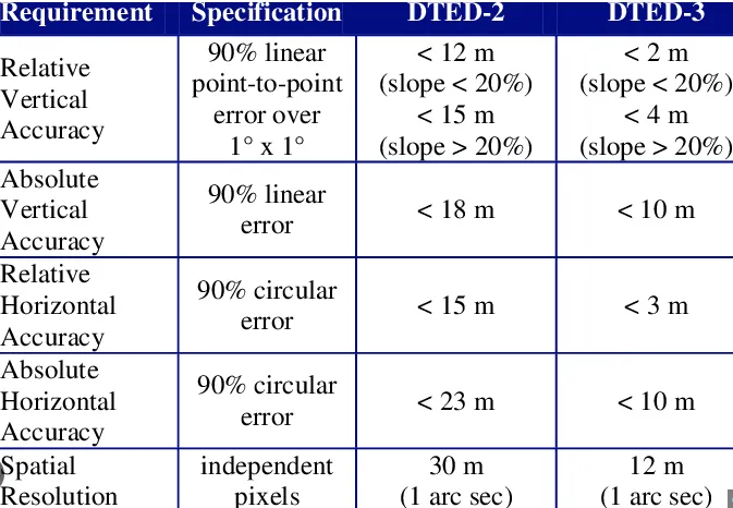
2. Comparison of DTED levels.
File Opening Mode
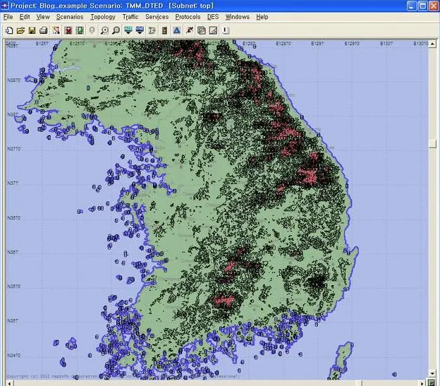
1. DTED in software.
Related GIS files
References
- https://en.wikipedia.org/wiki/DTED
- https://gdal.org/en/stable/drivers/raster/dted.html
- https://pro.arcgis.com/en/pro-app/3.4/tool-reference/data-management/raster-to-dted.htm