 Service

3D Tiles (Cesium Standard)
Nov 24,2025
GISBox is a one-stop 3D GIS data editing, conversion and publishing platform that supports editing in multiple GIS formats such as OSGB/GEOTIFF/RVT, converting to 3DTiles/Terrain and publishing.
Introduction
3D Tiles (Cesium Standard), as an open standard, defines methods for streaming transmission and visualization of large-scale 3D geospatial data on the web. Proposed and open-sourced by the Cesium team, it has now become an OGC (Open Geospatial Consortium) Candidate Standard and is widely used in digital cities, smart campuses, geological exploration, and other fields. Its core design employs a Hierarchical Level of Detail (HLOD) structure, which uses spatial partitioning algorithms to divide 3D models into multi-resolution tiles. This supports dynamic data loading based on the view frustum range, effectively addressing issues in traditional 3D models such as excessive memory usage and rendering lag in browsers.
File Structure
3D Tiles (Cesium Standard) primarily consists of the following components in its file structure:
- Tileset: Serving as the top-level management unit of 3D Tiles, the tileset is defined by a tileset.json file that describes the metadata and spatial structure of the entire dataset.
- Tile: As the fundamental unit of data, tiles are categorized into four main types: Batched 3D Model (b3dm), Instanced 3D Model (i3dm), Point Cloud (pnts), and Composite (cmpt).
- Auxiliary Files: These support the organization and rendering of tiles, including the Feature Table and Batch Table.
Pros
- Multi-Platform Support: Built on WebGL and JavaScript technologies, it operates across PCs, mobile devices, cloud servers, and other platforms, enabling seamless cross-platform applications.
- Efficient Data Management: Utilizes dynamic loading and Level of Detail (LOD) techniques to adaptively adjust data resolution based on user perspective and distance, enhancing rendering performance. Supports multiple compression algorithms (e.g., DRACO, LZMA) to significantly reduce file size.
- Openness and Extensibility: As an OGC standard, it benefits from a robust developer community and ecosystem, allowing flexible data structure design and extensions. Compatible with diverse data types (e.g., oblique photography, BIM, point clouds), facilitating the integration of heterogeneous data sources.
- High-Performance Rendering: Employs tiling (Tileset) and spatial hierarchical structures to enable efficient streaming and rendering of large-scale datasets, eliminating the need for single-batch loading.
Cons
- High Production and Conversion Costs: Requires specialized tools (e.g., K3DMaker) for data conversion, presenting a significant technical barrier.
- Data Security Risks: Network-accessible data may be vulnerable to leakage or unauthorized use.
- Functional Limitations: Lacks support for animation and interactive features, resulting in reduced flexibility compared to other 3D formats like FBX.
- Hardware and Network Demands: High-precision models can reach tens of gigabytes, imposing high requirements on browser memory, network bandwidth, and hardware performance, often leading to loading delays or lag.
Application Scenario
3D Tiles (Cesium Standard), as an open specification specifically designed for large-scale 3D geospatial data, focuses on application scenarios requiring efficient streaming and rendering of massive heterogeneous datasets. It is widely used in constructing digital twin cities, where it enables visualization and interaction with high-precision geospatial scenes by loading oblique photography models, BIM data, and other sources. Additionally, it supports dynamic data integration and real-time simulation in contexts such as smart campuses and natural resource management. Furthermore, 3D Tiles can be applied to point cloud processing, building cluster rendering, and multi-source data integration, providing a standardized solution for web-based 3D GIS applications.
Example
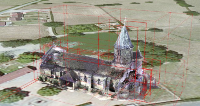
- 3DTiles enables efficient loading and rendering of 3D models.
File Opening Mode
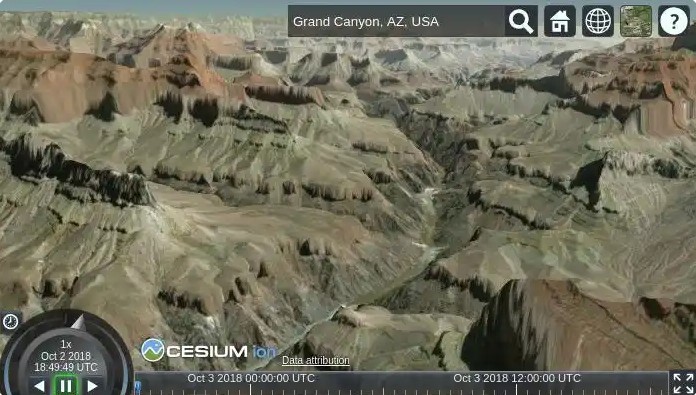
- How to open 3DTiles in Cesium.
Related GIS files
References
1. https://cesium.com/why-cesium/3d-tiles/
2. https://www.ogc.org/standards/3dtiles/
3. https://github.com/CesiumGS/3d-tiles