 Service

Wagner IV Projection
Nov 5,2025
GISBox is a one-stop 3D GIS data editing, conversion and publishing platform that supports editing in multiple GIS formats such as OSGB/GEOTIFF/RVT, converting to 3DTiles/Terrain and publishing.
Introduction
Wagner IV Projection is an equal area pseudo cylindrical map projection proposed by Karl Wagner, suitable for world map drawing. Its characteristics are that the longitude is an elliptical curve, the latitude is a straight line, the poles are straight and half the length of the equator, it can maintain equal area but has distortion in shape and angle, especially suitable for small-scale equal area world maps.
Projection Basic
The Wagner IV Projection is a combination of elliptical curves (meridians) and straight lines (parallels) that convert the latitude and longitude lines of the Earth's surface, with poles presented in straight lines and half the length of the equator. This projection achieves equal area through mathematical adjustment, but there are significant distortions in shape and angle in low latitude regions, especially suitable for world maps that require accurate area representation. Its design combines a compromise solution of elliptic curves and linear grids to balance the deformation problem in high latitude regions.
Pros
1. Equivalency: It can accurately maintain the area ratio of each region on the map, suitable for thematic maps that require area accuracy (such as population and resource distribution).
2. Low latitude distortion is relatively small: In the vicinity of the equator, the deformation of shape and distance is relatively controllable, making it suitable for displaying data in tropical regions.
3. Visual balance: The meridians are elliptical curves, the parallels are straight lines, and the overall layout is relatively symmetrical, suitable for the universal display of world maps.
Cons
1. Significant high latitude distortion: The polar region is severely stretched, with obvious shape and angle distortions, making it unsuitable for polar thematic maps.
2. Directional distortion: Except for the central meridian, the azimuth angles in other directions cannot be maintained accurately, which limits the navigation function.
3. Complex grid design: The meridians are elliptical curves, and the computational and mapping complexity is higher than that of simple cylindrical projections (such as equidistant cylinders).
Application Scenario
The Wagner IV Projection is mainly suitable for world maps that require precise area representation, especially for small-scale thematic maps such as population distribution and resource statistics. Its equal product characteristic gives it advantages in areas such as climate research and ecological analysis that require area comparison, but high latitude distortions limit the application of polar data.
Example
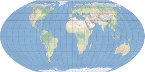
1. The Wagner IV map projection displays Greenwich as the center.
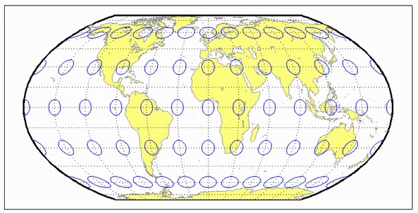
2. Wagner IV projection.
Related GIS Projections
Transverse Mercator Projection
Longitude / Latitude Projection
References
- https://pro.arcgis.com/fr/pro-app/latest/help/mapping/properties/wagner-iv.htm
- https://ww2.mathworks.cn/help/map/wagner4.html