 Service

Reverse Geocoding API
Nov 5,2025
GISBox is a one-stop 3D GIS data editing, conversion and publishing platform that supports editing in multiple GIS formats such as OSGB/GEOTIFF/RVT, converting to 3DTiles/Terrain and publishing.
Introduction
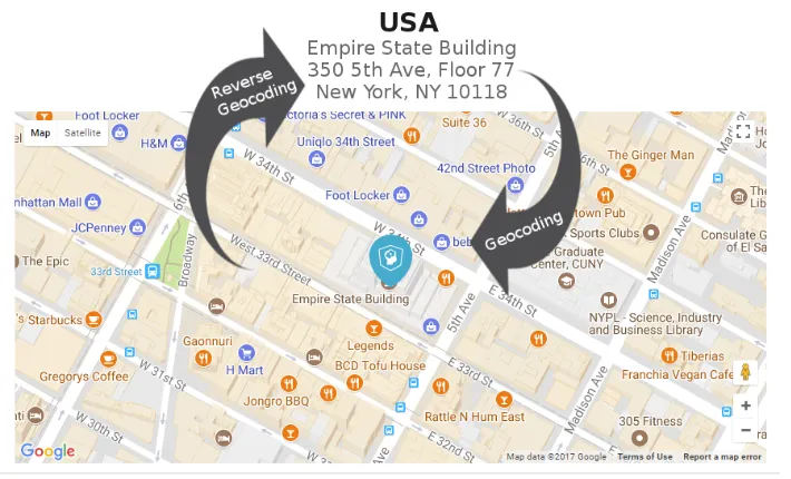
Reverse Geocoding API is a technical interface that converts longitude and latitude coordinates into human-readable addresses. It automatically returns the corresponding structured address information (such as "Tiananmen Square, Dongcheng District, Beijing") by inputting GPS coordinates (such as 116.404,39.915), and supports the attachment of surrounding POI (points of interest) data. This service is widely used in map navigation, logistics tracking, location analysis and other scenarios, and is one of the core components of LBS (location-based services).
File Structure
The following is a typical file structure of the Reverse Geocoding API service:
- API documentation: interface specifications, call examples, version update instructions.
- Request parameters: required/optional parameter descriptions (such as coordinate format, language, return field control).
- Response format: JSON/XML data structure definition for success/failure.
- Error handling: status code comparison table and solutions.
- SDK resources: SDK integration packages for various languages (Java/Python, etc.).
- Quota management: QPS limit, quota application guide.
Pros
- Improve user experience: Convert longitude and latitude coordinates into intuitive address information to facilitate users to understand the location and enhance the practicality of the application.
- Support multi-scenario applications: Widely used in map navigation, social media location sharing, food delivery and other scenarios to meet diverse needs.
- Data richness: Can return administrative divisions, surrounding POIs (points of interest), road information, etc., to provide a comprehensive description of geographic location.
- Flexibility: Support developers to choose different versions of administrative division data or road information according to business needs to meet personalized needs.
Cons
- Geographic data accuracy issues: Data in some areas may not be accurate enough, resulting in errors between the returned address information and the actual location.
- Data update delay: Newly built buildings, roads or place names may not be included in the API database in time, affecting the timeliness of information.
- Ambiguous geographic boundaries: The boundaries of some areas are unclear, which may cause the same coordinate point to return different results between different services.
- Dependence on network connection: Reverse geocoding services usually require network support, and unstable network may affect service availability.
- Cost and quota restrictions: Using third-party APIs may involve fees, and some services have request frequency or quota restrictions.
Application Scenario
The Reverse Geocoding API is widely used in map navigation, logistics distribution, social sharing, data analysis, and emergency rescue. In map navigation, it can convert GPS coordinates into user-readable addresses to improve positioning accuracy; logistics distribution relies on it to analyze the real-time location of drivers or riders and optimize route planning; in social sharing, it automatically generates location tags (such as "Chaoyang District, Beijing") to enhance the interactive experience; in data analysis, the longitude and latitude collected by the device are converted into structured addresses to facilitate business decisions; emergency rescue uses coordinates to quickly locate the accident scene and improve response efficiency. These applications all rely on efficient conversion of coordinates to addresses to serve various digital scenarios.
Example
1. Draw a custom area map using reverse geocoding.
2. Reverse Geocoding.
File Opening Mode
1. View the published geocode service.
_1763976092554.png)