HDF (Hierarchical Data Format)
HDF (Hierarchical Data Format) is a file format used to store and manage large scientific data sets. It is a container for multidimensional arrays and complex data structures, and is widely used in science, engineering, and research. It can store many types of data, including numerical values, images, audio, text, etc. It supports hierarchical structures, allowing data sets to be stored and accessed in a multi-level organizational manner, facilitating data organization, retrieval, and analysis.
2025-09-16 14:47:37Polar Stereographic Projection
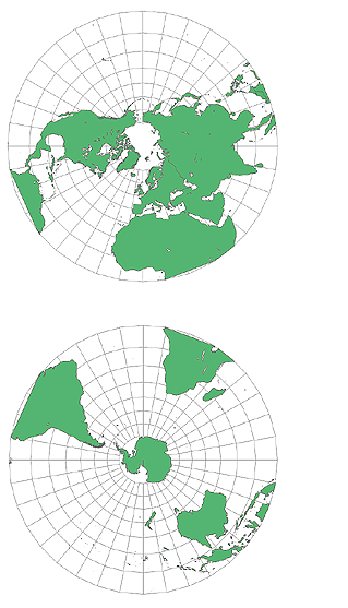
The polar stereographic projection is a method of projecting the earth’s surface onto a plane. With the pole as the center, the points on the earth’s surface are projected onto a plane tangent to the pole through rays. The core principle is to regard the earth as a sphere, with the pole as the viewpoint, the projection surface as a plane tangent to the pole, the meridians projected as radial straight lines, the latitudes projected as concentric circles, and the meridians and latitudes intersecting at right angles, presenting a spider web shape. This projection method can keep the local angles and shapes unchanged, with less deformation in polar regions, and can accurately maintain the relative distance relationship between points on the earth’s surface, ensuring that the direction on the map is consistent with the actual geographical direction.
2025-09-16 14:47:03KMZ (Keyhole Markup Language Zipped)
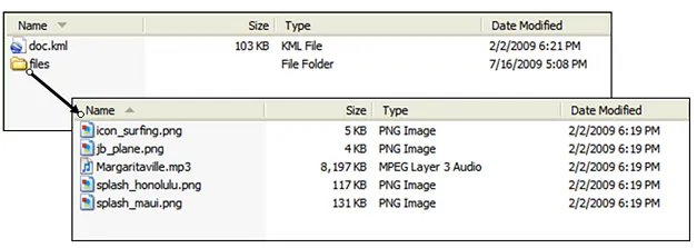
KMZ is a file format for geospatial data and is a compressed version of a KML (Keyhole Markup Language) file. KML is a standardized markup language developed by Google for representing geospatial information and displaying it in mapping applications such as Google Earth and Google Maps. KMZ files reduce the file size by compressing the KML file and its associated resources (such as images and 3D models), making them easier to transfer and share.
2025-09-16 14:47:23Geographic Coordinate System(GCS)
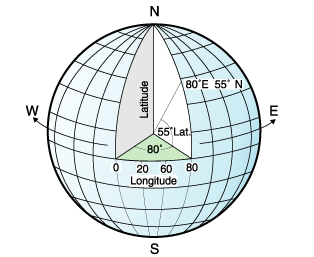
Geographic Coordinate System (GCS) is a coordinate system based on a sphere or ellipsoid that is used to define locations on the surface of the Earth. It describes a location using two angular coordinates (usually latitude and longitude), and the third value can be an optional altitude value. GCS is widely used in fields such as geographic information systems (GIS), mapping, and navigation, and is the basis for expressing geographic data.
2025-09-16 14:47:05NAD83 (North American Datum 1983)
NAD83 (North American Datum 1983) is a geographic coordinate system (geographic reference system) widely used in North America, especially in the United States, Canada, and Mexico. It is a modernized, high-precision version of the previously used NAD27 (North American Datum 1927), developed with a focus on compatibility with GPS technology. Its EPSG code is 4269.
2025-09-16 14:47:083DD (ArcGlobe 3D Data)
3DD file format is a file format designed for 3D geographic information systems (3D GIS) to store 3D scene data. 3DD files are usually generated by GIS software (such as Esri’s ArcGIS Pro) and are a special format that integrates 3D geographic spatial information, model data, and related metadata. It can effectively support 3D visualization, spatial analysis, and scene management, and is an important tool for 3D GIS and virtual reality (VR) applications. The core advantage of 3DD files lies in their efficient organization and management of 3D geographic data, which is suitable for complex urban modeling, environmental simulation, and spatial analysis scenarios.
2025-09-16 14:47:45GeoDatabase
GeoDatabase is a geographic database used to store and manage geospatial data. It is a database format developed by Esri and is widely used in the field of GIS (Geographic Information System). GeoDatabase takes spatial data as its core and can store various geographic features and attribute information, such as maps, terrain, land use, road networks, water areas, etc. It supports a variety of data types, including points, lines, surfaces, rasters, topology, etc., and can accurately represent and process the location, shape and attributes of geographic objects.
2025-09-16 14:47:53FBX (FilmBox)
FBX (FilmBox) is a file format for 3D models, animations, and scenes. It is a universal exchange format developed by Autodesk for sharing and transferring data between different 3D software. The FBX format supports a variety of elements including geometric shapes, materials, animations, bones, etc., and can preserve the associations and hierarchical structures between these elements.
2025-09-16 14:47:59
 Service

