Service

GeoWebCache
Feb 11,2026
GISBox is a one-stop 3D GIS data editing, conversion and publishing platform that supports editing in multiple GIS formats such as OSGB/GEOTIFF/RVT, converting to 3DTiles/Terrain and publishing.
Introduction
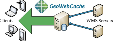
GeoWebCache is a high-performance, tile-caching server designed specifically for accelerating the delivery of geospatial map data over the web. It functions as a critical middleware component that sits between a map server (such as GeoServer, MapServer, or ArcGIS Server) and a map client (like OpenLayers, Leaflet, or MapLibre). By generating, storing, and serving pre-rendered map image tiles in standard web formats (PNG, JPEG, vector tiles), it dramatically reduces server load and improves response times for end users. Unlike rendering maps dynamically for each request, GeoWebCache serves pre-computed tiles, making it an essential tool for building scalable, fast, and responsive web mapping applications that serve large volumes of concurrent users.
File Structure
GeoWebCache operates with a structured approach to tile storage and configuration, optimizing both disk usage and retrieval speed.
- Tile Storage Structure (Disk Quota): Tiles are organized in a predictable directory hierarchy on the filesystem, typically following the pattern /{layer}/{gridset}/{zoom_level}/{x}/{y}.{format}. This structure allows for efficient storage, pruning, and direct file serving by web servers.
- Configuration Files: geowebcache.xml: The primary configuration file defining global settings, tile layer configurations, grid sets (coordinate reference systems and zoom levels), storage paths, and service endpoints (WMTS, TMS, WMS-C).Tile Layer Configuration: Each cached layer (e.g., from a WMS source) has its configuration specifying the source URL, supported formats, grid sets, meta-tiling options, and expiration policies.
- Cache Seed/Truncate Tools: Includes command-line and REST API tools for pre-generating (seeding) the tile cache for specific areas and zoom levels, or removing (truncating) outdated tiles.
- Integration Modes: Can be deployed as a standalone servlet (WAR file), integrated directly as a module within GeoServer (leveraging its data sources natively), or configured as a proxy for external WMS services.
Pros
- Significant Performance Enhancement: Serves map tiles as static files, which are orders of magnitude faster to deliver than dynamically rendered maps, leading to near-instantaneous map panning and zooming for end-users.
- Reduces Origin Server Load: By caching tiles, it drastically decreases the number of requests hitting the backend map server (e.g., GeoServer), freeing up resources for other tasks and enabling service scalability.
- Standard Compliance and Interoperability: Natively supports and serves tiles via OGC WMTS (Web Map Tile Service), TMS (Tile Map Service), and Google Maps/OSM tiling schemes, ensuring compatibility with virtually all modern web mapping libraries.
- Flexible Deployment and Integration: Can be used as a transparent proxy/cache for any standard WMS, tightly integrated with GeoServer for streamlined management, or deployed as a standalone tile server for optimized delivery.
Cons
- Storage Consumption and Management Overhead: Caching tiles for multiple layers, at high zoom levels, and over large geographic extents can consume terabytes of disk space, requiring careful storage planning and cleanup policies.
- Data Freshness Challenge (Staleness): The cache inherently serves pre-rendered images. When the underlying source data changes, the cached tiles become stale, requiring manual or automated cache truncation and re-seeding, which can be a complex and time-consuming process.
- Initial Seeding Time Cost: Pre-generating a full cache (warm-up) for a large area is a computationally intensive and slow process that must be completed before users can benefit from the full performance gain.
- Increased System Complexity: Introduces an additional component to the geospatial stack that requires configuration, monitoring, and maintenance, adding to the overall system administration burden.
Application Scenario
The core application scenario of GeoWebCache is to provide acceleration and load buffering for web mapping services requiring high concurrency and performance. By pre-generating and caching map tiles, it significantly enhances the browsing speed and responsiveness of online maps, making it suitable for high-traffic map publishing scenarios such as public geospatial information portals and enterprise GIS dashboards. In mobile mapping applications, it supports offline map package pre-caching and optimized network transmission. By integrating with Content Delivery Networks (CDNs), it enables the construction of a globally distributed map tile acceleration system. Ultimately, GeoWebCache transforms dynamic map services into efficiently distributable static resources, ensuring optimal user experience while dramatically reducing the computational and concurrent load on backend map servers.
Example
1. GeoWebCache.