 Service

OpenRouteService API
Dec 29,2025
GISBox is a one-stop 3D GIS data editing, conversion and publishing platform that supports editing in multiple GIS formats such as OSGB/GEOTIFF/RVT, converting to 3DTiles/Terrain and publishing.
Introduction
OpenRouteService API is an application programming interface (API) that provides route planning, navigation, and geocoding services. It supports multiple transportation modes (such as walking, cycling, driving, etc.) and can be integrated into map applications to enable route calculation and navigation functionality. Through its open interface, it offers location-based services for developers, making it suitable for application development requiring route optimization or navigation features.
File Structure
The file structure of the OpenRouteService API primarily involves the following aspects:
- Directions (Route Planning): This is the core part of the API, responsible for calculating routes for different transportation modes (e.g., driving, cycling, walking). It handles pathfinding, travel time, and distance estimation.
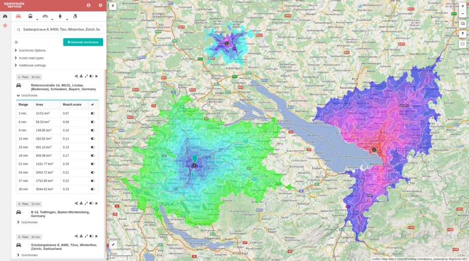
- Isochrones: This section is used to calculate the geographical area reachable from a specific point within a given time or distance, commonly applied in accessibility analysis.
- Geocoding: Provides conversion between addresses and geographic coordinates, including forward geocoding (address to coordinates) and reverse geocoding (coordinates to address).
- Places (Location Search): Supports searching for specific places or points of interest (POI) based on keywords or categories and returns detailed information.
- Elevation Data: Used to obtain altitude information for specific locations or to calculate elevation profiles along routes, aiding in route analysis.
- Optimization (Route Optimization): Focuses on solving complex route optimization problems, such as the Vehicle Routing Problem (VRP), to find efficient sequences for multi-destination trips.
Pros
- Multi-Mode Transportation Support: Supports route planning for various transportation modes like walking, cycling, and driving, meeting the needs of different application scenarios.
- Global Coverage: Based on OpenStreetMap data, it provides geographic and routing services worldwide.
- High Performance and Customizability: Efficient route calculation supports complex optimizations (e.g., Vehicle Routing Problem, VRP), suitable for high-precision requirements.
- Developer-Friendly: Provides client libraries for Python, JavaScript, etc., simplifying the integration process.
Cons
- Usage Barrier: Requires registering for an API key, and the configuration process can be complex for novice users.
- Inadequate Documentation and Community Support: Official documentation and developer community resources are relatively limited, making issue troubleshooting reliant on technical experience.
- High Learning Curve for Advanced Features: Some optimization features (e.g., isochrone analysis) require a deep understanding of geographic algorithms to fully utilize.
Application Scenario
The OpenRouteService API has broad application coverage across multiple fields, primarily including route optimization in logistics and delivery (e.g., food delivery rider route planning, multi-vehicle dispatch scheduling), isochrone analysis in urban planning (evaluating regional accessibility), real-time navigation and geographic search (providing route suggestions combined with traffic dynamics), and transportation management scenarios such as vehicle route optimization (VRP) and time-distance matrix calculations. Additionally, it supports POI queries (e.g., searching for nearby facilities) and terrain elevation data acquisition (for outdoor route planning), making it applicable to logistics, transportation, GIS development, and outdoor sports applications. Developers can quickly integrate routing services through its API, such as generating walking isochrones in QGIS or building custom navigation systems.
Example
1. The OpenRouteService API provides global spatial services by directly accessing free geographic data generated and collaboratively collected from OpenStreetMap.
2. Interactive API documentation application.

File Opening Mode
1. A JavaScript code example for calling the OpenRouteService API to obtain navigation.
