Service

UTM Zone (Universal Transverse Mercator Coordinate System)
Nov 24,2025
GISBox is a one-stop 3D GIS data editing, conversion and publishing platform that supports editing in multiple GIS formats such as OSGB/GEOTIFF/RVT, converting to 3DTiles/Terrain and publishing.
Introduction
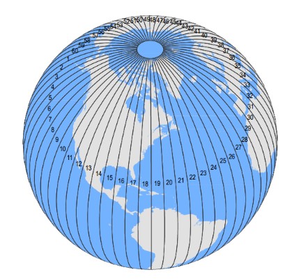
UTM Zone (Universal Transverse Mercator Coordinate System) is a coordinate system that converts latitude and longitude coordinates on the Earth's surface into a planar Cartesian coordinate system. It is widely used in map creation, engineering surveying, and military applications. Its core principle involves reducing distortion through zonal projection and achieving high-precision positioning through standardized coordinate representation.
Coordinate System Composition
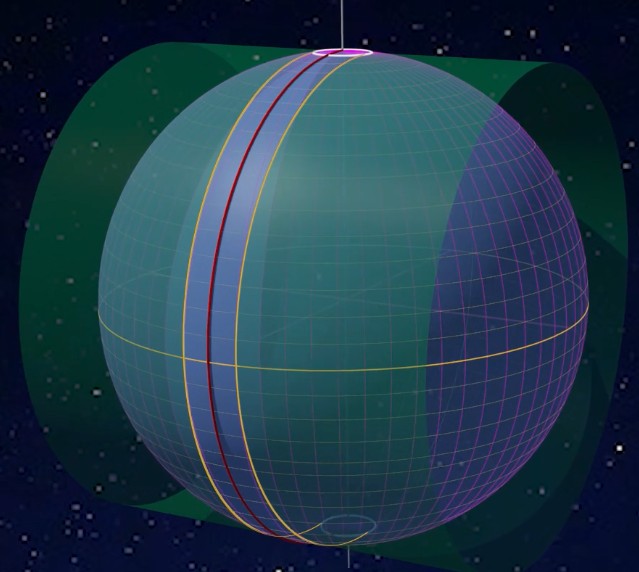
- Zonal Division: Longitude is divided into 60 zones of 6° each (Zones 1-60), while latitude is divided into 20 bands of 8° each (designated by letters C-X, excluding I and O).
- Projection Parameters: Uses a transverse Mercator projection with a central meridian scale factor of 0.9996. False easting is set at 500,000 meters, with false northing at 0 meters for the Northern Hemisphere and 10,000,000 meters for the Southern Hemisphere.
- Coordinate Representation: Coordinates are expressed in the format "Longitude Zone Latitude Band Easting Northing" (units in meters).
Pros
- Conformal Property: As a conformal transverse secant cylindrical projection, UTM preserves angular relationships, making it ideal for map applications requiring accurate shape representation.
- Zonal Design: The 6° longitude zones and 8° latitude bands (totaling 60 longitude zones and 20 latitude bands) effectively minimize linear distortion within local areas, particularly in low to mid-latitudes.
- False Offset Configuration: A fixed false easting of 500,000 meters and false northing of 0 meters (Northern Hemisphere) or 10,000,000 meters (Southern Hemisphere) eliminate negative values, simplifying coordinate calculations.
- Global Applicability: Covers latitudes from 84°N to 80°S, supporting large-scale maps and global applications such as military operations and resource satellite imagery.
Cons
- Incomplete Global Coverage: The UTM projection does not cover polar regions (north of 84°N and south of 80°S), limiting its use in global applications.
- Distortion in 3° Zones: In 3° zoning configurations, the maximum scale distortion (approximately -0.0004) occurs along the central meridian, potentially making it less accurate than the Gauss-Krüger projection in some cases.
- Lack of International Standardization: Although adopted by over 60 countries, differences in the reference ellipsoids used by various nations lead to inconsistencies in coordinate systems, necessitating careful conversion.
Application Scenario
The UTM zoned coordinate system is used in military operations for precise global positioning and navigation, ensuring rapid and accurate location determination for combat units. In resource satellite imagery, it provides a unified coordinate benchmark for global resource surveys and environmental monitoring, facilitating data integration and analysis. For large-scale map creation, UTM's zonal projection effectively minimizes linear and areal distortions, making it suitable for topographic maps, engineering surveys, and other high-precision applications. Additionally, UTM is widely employed in logistics, field exploration, and Geographic Information Systems (GIS), providing reliable planar coordinate support for various geospatial data.
Example
1. UTM zone (Universal Transverse Mercator coordinate system).
2. UTM Universal Transverse Mercator.