China Geodetic Coordinate System 2000(CGCS2000)
GISBox is a one-stop 3D GIS data editing, conversion and publishing platform that supports editing in multiple GIS formats such as OSGB/GEOTIFF/RVT, converting to 3DTiles/Terrain and publishing.
Introduction
The 2000 coordinate system, namely the China Geodetic Coordinate System 2000 (CGCS2000 for short), is a new generation of geocentric coordinate system released by the National Administration of Surveying, Mapping and Geoinformation of China in 2008, replacing the Xi’an 1980 coordinate system. CGCS2000 adopts the standard of the International Terrestrial Reference Frame (ITRF) and is highly compatible with the WGS84 coordinate system (the earth coordinate reference system used worldwide). Its geodetic datum is based on the GRS80 ellipsoid (the 1980 International Reference Ellipsoid), with accurate geocentric positioning, and is suitable for various precise measurements and geographic information processing.
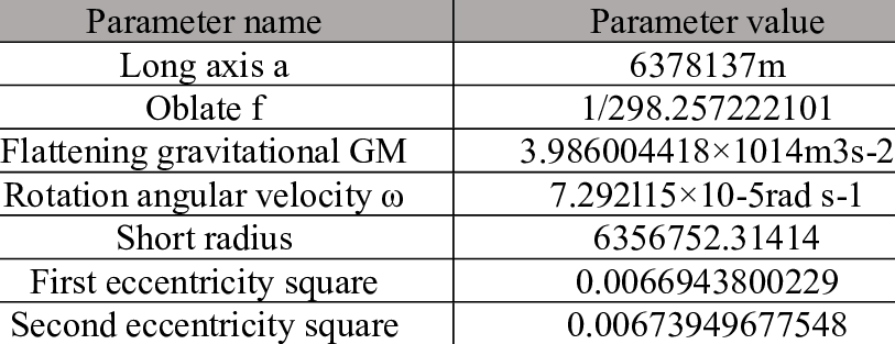
Parameter
Common data formats for the CGCS2000 coordinate system include:
- Vector data format
● Shapefile (.shp): Mainly used to store the spatial location, shape and attribute information of geographic features.
● GeoJSON: Based on the JSON format, it is used to store simple geographic features, which is convenient for network transmission and application development.
● GML: Based on XML, it is used for complex geographic information exchange.
- Raster data format
● GeoTIFF: Image file format with geographic reference information.
● IMG: Common format for remote sensing data, supporting large-scale data storage.
- Database storage
● PostGIS: A geographic database based on PostgreSQL that supports CGCS2000 data storage and operation.
● File Geodatabase (.gdb): A file-based database provided by Esri.
- Other formats
● DXF/DWG: Used for interaction between CAD and GIS systems.
● KML/KMZ: Used to display geographic information in Google Earth.
Pros
Global standards: The high compatibility of CGCS2000 and WGS84 gives it advantages in international applications and can easily convert to and from global coordinate data.
Geocentric accuracy: Based on the GRS80 ellipsoid and ITRF geocentric coordinate system, the geocentric accuracy of CGCS2000 has been significantly improved, making it suitable for high-precision measurements and applications.
Uniformity: As China’s legal reference system, CGCS2000 is widely used in surveying and mapping and geographic information systems nationwide, unifying data standards among provinces, cities and departments.
Supports multiple projections: CGCS2000 can support multiple projection methods (such as Gauss-Krüger projection, UTM projection), flexibly adapting to diverse application needs.
Cons
Conversion complexity: The conversion process from the 1980 Xi’an coordinate system or WGS84 coordinate system to CGCS2000 is complex, involving precise conversion parameters and models.
Historical data compatibility: Since CGCS2000 is a new coordinate system, many historical data are still based on the Xi’an 1980 coordinate system, which requires coordinate conversion, consuming time and resources.
Regional difference accuracy: Although CGCS2000 has high accuracy, errors may still occur in localized applications in a few remote areas, requiring additional adjustments.
Application Scenario
The CGCS2000 coordinate system has been widely used in many industries, greatly promoting the process of digitalization and refined management in China. In surveying and mapping, CGCS2000 provides a unified geographic reference framework for topographic map production and the collection and management of basic geographic information. In the field of remote sensing and environmental monitoring, it is used for the correction and analysis of image data, providing precise support for ecological protection, resource management and climate change research. In engineering construction, CGCS2000 is an important measurement benchmark for the design and construction of large-scale infrastructure projects such as railways, roads, bridges, etc. At the same time, in urban planning, it optimizes land use and urban layout through three-dimensional model construction and spatial analysis. In addition, CGCS2000 ensures the global compatibility of data in traffic navigation systems, helps rapid positioning and resource allocation in disaster emergencies, and provides precise positioning and guidance services in national defense and military.
Example
- The reference frame of CGCS2000.

- CGCS2000 coordinate system Params