 Service

Esri GeoEvent Server
Nov 24,2025
GISBox is a one-stop 3D GIS data editing, conversion and publishing platform that supports editing in multiple GIS formats such as OSGB/GEOTIFF/RVT, converting to 3DTiles/Terrain and publishing.
Introduction
Esri GeoEvent Server is an enterprise-level software provided by Esri, designed for real-time processing, analysis, and dissemination of event-based geospatial data streams. It can connect to multiple real-time data sources, perform real-time analysis on event data through filters and processors, and deliver processed results to client applications, feature services, dashboards, or other destinations. This technology is commonly used in smart cities, traffic monitoring, and other scenarios requiring real-time responsiveness, helping users quickly adapt to dynamic changes.
File Structure
The file structure of Esri GeoEvent Server primarily involves the following aspects:
- Configuration Directory (etc): This directory stores core configuration files, such as ArcGISGeoEvent.cfg for launching the Java Virtual Machine, and parameter files defining global settings like input connector buffer sizes.
- Software Development Kit (sdk): Located in the GeoEvent/sdk folder under the installation directory, it provides documentation, architectural descriptions, and sample code for developing custom components like transports and adapters.
- Log Directory (data/log): System operation and processing logs are stored here, with critical runtime information recorded in the karaf.log file.
- Runtime Data and Cache: The system includes cache configuration files for managing service ID tracking.
Pros
- Real-Time Data Processing Capability: Supports real-time data ingestion, processing, and analysis, making it suitable for scenarios requiring rapid responses.
- Enterprise-Grade Stability: As a commercial API, it is maintained by a professional team, offering high stability and comprehensive documentation, ideal for large-scale enterprise applications.
- Scalability: Can integrate with distributed systems like Apache Kafka to enhance throughput and robustness, supporting horizontal expansion.
- Integrated Ecosystem: Seamlessly integrates with the ArcGIS platform, supporting data storage, connector configuration, and GeoEvent service management.
Cons
- High Cost: Commercial licensing fees are substantial, making it less accessible for startups or users with limited budgets.
- Dependency on a Closed Ecosystem: The source code is not open, and feature updates are vendor-dependent, limiting customization flexibility.
- Deployment Complexity: Requires specific environments (e.g., ArcGIS Server) and additional technical investment for cluster configuration.
Application Scenario
Esri GeoEvent Server is primarily used in scenarios requiring real-time processing and analysis of geospatial event streams, such as enterprise-level real-time monitoring (e.g., traffic management, emergency response, and other high-reliability use cases). It can connect to IoT sensors for real-time monitoring of environmental data like noise and air quality, with threshold-based alerts. The technology also supports tracking moving targets (e.g., vehicles, personnel) with geofencing and trajectory alerts. Furthermore, it integrates with facility management systems to enable real-time status monitoring and fault prediction for large-scale infrastructure like power equipment, supporting dynamic decision-making in smart city applications.
Example
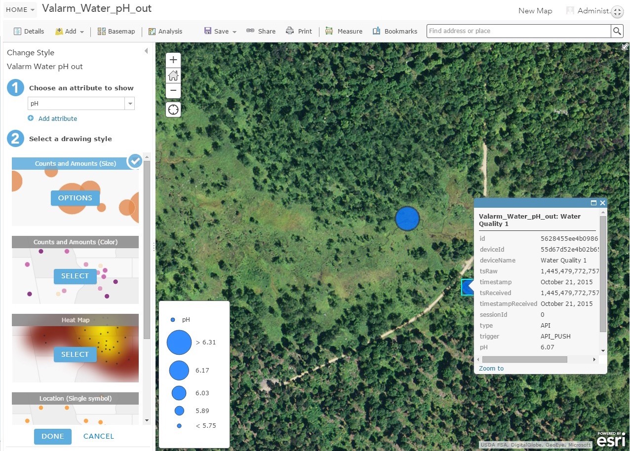
1. Use the Event Viewer to visualize the sampled real-time data in GeoEvent Manager.

2. Real-time sensors and Valarm tools cloud + Esri GeoEvent extension to ArcGIS server.
File Opening Mode
1. ArcGIS Operations Dashboard.
Related GIS Services
References
- https://enterprise.arcgis.com/zh-cn/geoevent/11.1/get-started/what-is-arcgis-geoevent-server.htm
- https://www.esri.com/arcgis-blog/products/ext-server-geoevent/real-time/whats-new-in-arcgis-geoevent-server-at-10-8
- https://www.valarm.net/blog/real-time-sensors-with-valarm-tools-cloud-esri-geoevent-extension-for-arcgis-server/#noopener/15/