Service

Beijing 1954 (Beijing 1954 Coordinate System, EPSG:4214)
Jan 23,2026
GISBox is a one-stop 3D GIS data editing, conversion and publishing platform that supports editing in multiple GIS formats such as OSGB/GEOTIFF/RVT, converting to 3DTiles/Terrain and publishing.
Introduction
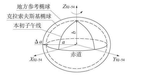
Beijing 1954 (Beijing 1954 Coordinate System, EPSG:4214) is a national geodetic datum established in China during the 1950s. As the first nationwide unified coordinate system introduced after the founding of the People’s Republic of China, it is a non-geocentric (local) datum designed for nationwide surveying and mapping. It was developed with reference to the Soviet geodetic framework and is based on the Krasovsky 1940 ellipsoid. This coordinate system was used extensively across China for foundational surveying, topographic mapping, infrastructure construction, and land administration over a long period, forming the basis of China's surveying and mapping system in the latter half of the 20th century. Although it has now been officially replaced by the more precise and geocentric CGCS2000, it still plays a significant role in processing historical and legacy data.
Coordinate System Composition
Beijing 1954 (EPSG:4214) is a two‑dimensional geographic coordinate system (longitude and latitude) based on the Krasovsky 1940 ellipsoid. Its origin is non‑geocentric and optimized for China’s domestic geodetic network, making its definition different from modern global geocentric systems such as WGS84. In practice, it is often used in combination with the Gauss‑Krüger projection as a projected coordinate system and was widely applied for producing large‑ to medium‑scale topographic maps across China.
Pros
- Establishment of a Unified National Geodetic Datum: Beijing 1954 served as China’s first unified modern geodetic standard, integrating previously disparate regional surveying references. This enabled systematic nationwide mapping, land administration, and infrastructure development.
- High Practical Accuracy for Its Time: Although non‑geocentric, it was designed to fit the territory of China and achieved sufficient surveying accuracy under the technical conditions of the period, meeting practical demands for decades.
- Significant Contributions to Surveying and National Development: Widely used in topographic mapping and national projects such as roads, railways, and water conservancy facilities, it played a key foundational role in China’s early modernization and land development.
Cons
- Incompatibility with Geocentric Systems: As a non‑geocentric datum, it exhibits systematic discrepancies on the order of tens to hundreds of meters compared to WGS84 or CGCS2000 and cannot be directly aligned with satellite positioning data such as GPS.
- Low International Compatibility: Designed primarily for domestic use in China, it has limited direct compatibility with international geospatial data.
- Officially Superseded: CGCS2000 is now officially adopted as China's national geodetic datum, and Beijing 1954 is no longer used for new projects.
- Requires Specialized Conversion: Transforming to modern coordinate systems demands appropriate datum transformation parameters (translation, rotation, and scale), and errors can arise if regional variations are not accounted for.
Application Scenario
Beijing 1954 (EPSG:4214) is primarily used in historical and practical contexts involving the management and reuse of legacy data. It serves as a reference for accurately interpreting and converting coordinates recorded in topographic maps, cadastral plans, infrastructure design drawings, and various survey results created between the 1950s and 1990s. This enables the integration of past surveying outcomes into modern systems such as CGCS2000 or WGS84, making it possible to utilize them in current GIS environments. It thus provides significant value for analyzing land‑use changes, managing infrastructure history, verifying legal boundaries, and conducting historical geography research.
Example
1. Belgium Lambert 72 – EPSG:31370.