Service

NAD27 (North American Datum 1927)
Dec 29,2025
GISBox is a one-stop 3D GIS data editing, conversion and publishing platform that supports editing in multiple GIS formats such as OSGB/GEOTIFF/RVT, converting to 3DTiles/Terrain and publishing.
Introduction
NAD27 (North American Datum 1927) is a geodetic datum established in 1927 for North America, defined based on the Clarke 1866 ellipsoid with its origin at Meades Ranch in Kansas, USA. This datum served as the official mapping and surveying standard for the United States, Canada, and Mexico for decades, widely used in historical topographic maps, land ownership records, and traditional geographic data. Although its accuracy is limited by early surveying technology and it has been superseded by more modern datums (e.g., NAD83), a significant number of historical archives and legacy systems still rely on NAD27. Therefore, special attention must be paid to datum transformations when dealing with older geographic data in North America.
Coordinate System Composition
- Ellipsoid: Clark 1866 ellipsoid (semi-major axis 6,378,206.4 meters, flattening 1/294.9786982).
- Origin: Meades Ranch, Kansas, USA.
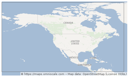
- Coverage: Primarily serves North America, extending to parts of Central America and the Caribbean.
- Coordinate Format: Usually expressed in latitude and longitude (decimal degrees, minutes, and seconds).
Pros
- Historical Continuity
: As the primary geodetic datum for North America in the 20th century, NAD27 aligns seamlessly with vast amounts of historical maps, land ownership records, and engineering drawings, making it an essential reference for studying historical geographic data in North America. - Regional Optimization
: Designed based on early North American triangulation networks, it provides relatively high accuracy near its origin (Meades Ranch), making it suitable for traditional local surveying needs. - Legal and Administrative Compatibility
: Many early cadastral systems, mining rights boundaries, and the Public Land Survey System (PLSS) in the United States still legally reference NAD27. Direct use helps avoid legal disputes. - Alignment with Legacy Infrastructure
: Plans for older infrastructure (e.g., railways, irrigation canals, pipelines) were often based on NAD27. Continuing to use this datum for maintenance reduces the need for re-surveying.
Cons
- Limited Accuracy: Relies on triangulation techniques from the late 19th to early 20th centuries, resulting in lower overall accuracy (errors can reach hundreds of meters). Distortions are particularly significant in regions far from the North American mainland, such as Alaska and islands.
- Outdated Ellipsoid: The Clarke 1866 ellipsoid poorly approximates the Earth’s true shape compared to modern ellipsoids (e.g., GRS80, WGS84), leading to systematic deviations.
- High Complexity in Transformation: Converting between NAD27 and NAD83/WGS84 requires grid-based transformation files (e.g., NADCON), with parameters varying by region. This complexity increases the risk of errors in automated processing.
- Lack of Global Compatibility: NAD27 is only applicable to North America and is incompatible with international standards like WGS84. Global applications (e.g., GPS, satellite remote sensing) necessitate transformations, adding complexity to workflows.
- Lack of Technical Support: Modern GNSS devices and mainstream internet mapping APIs (e.g., Google Maps) do not natively output NAD27 coordinates, requiring additional development efforts or specialized tools for conversion.
- Risk of Datum Confusion: NAD27 and NAD83 coordinates appear similar but differ significantly. Unmarked datum mismatches can lead to engineering errors (e.g., misplaced excavations) or inaccurate data analysis.
Application Scenario
NAD27 (EPSG:4267) is primarily used for processing historical geospatial data in North America. Its applications include interpreting 20th-century official topographic maps, land ownership archives, infrastructure engineering drawings, and other legacy materials. It also serves as the original coordinate reference for resolving legal boundary disputes, cultural heritage research, and maintaining aging pipeline or utility systems. In modern geographic information workflows, NAD27 typically functions as an intermediate datum for data conversion. It must be transformed into NAD83 or WGS84 using specialized tools before integration with contemporary spatial data such as GPS or satellite imagery.
Example
1. The covered area of the coordinate reference system according to the EPSG database.