 Service

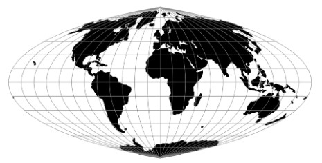
Putnins P2 Projection
Putnins P2 Projection is a pseudocylindrical equal-area map projection proposed by R. V. Putnins in 1934, primarily used for creating thematic world maps. This projection employs a specific mathematical method to transform the curved geometric features of the Earth onto a plane. It is characterized by a central meridian that is a straight line with a length half that of the equator, and parallels that are straight lines parallel to the equator, with spacing decreasing as latitude increases. There is no distortion along the central meridian or at latitudes 36°46′ N/S, but distortion gradually increases farther away from these areas.
2026-03-24 18:49:54
Kavrayskiy VI Projection
The Kavrayskiy VI Projection is a pseudocylindrical equal-area map projection. Its central meridian is a straight line with a length half that of the equator, while the other meridians are symmetrical sinusoidal curves curving toward the central meridian. The parallels are equally spaced straight lines perpendicular to the central meridian. The projection maintains true scale at latitudes 47°33′ N/S, with no distortion along these specific parallels. Although significant distortion occurs in polar regions, the overall distortion level is lower than that of most pseudocylindrical projections. Due to its equal-area property, it is suitable for statistical maps that require accurate representation of area proportions.
2026-03-24 18:43:32
Kavrayskiy V Projection
Kavrayskiy V Projection is a map projection proposed by Soviet scholar Vladimir Kavrayskiy. It belongs to the pseudocylindrical projection family and aims to balance angular and areal distortion, with minimal distortion near the standard latitudes of 47°33′ N/S. It is suitable for global map production, though some distortion remains in polar regions.
2026-03-24 18:40:20
Tokyo UTM Zones
Tokyo UTM Zones are historic projected coordinate systems applying the UTM projection to the Tokyo datum (Bessel 1841 ellipsoid), serving as Japan's fundamental geodetic framework until 2002. While modern systems like JGD2000/JGD2011 UTM zones have superseded them, these zones remain essential for interpreting 20th-century Japanese geographic data.
2026-03-14 13:57:54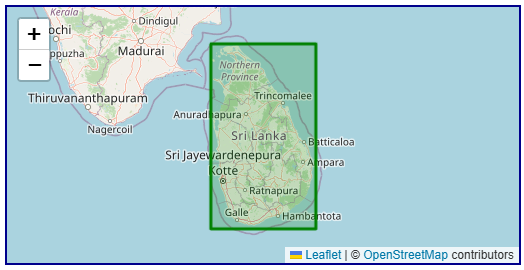
Sri Lanka Kandawala Grid
Sri Lanka Kandawala Grid is a historic projected coordinate system based on the Kandawala datum, established during the British colonial period to serve as the foundational mapping framework for the island nation. Developed in the early 20th century, this system employs a transverse Mercator projection to support cadastral surveying, topographic mapping, and engineering projects throughout Sri Lanka. While modern systems like SLD99 / Sri Lanka Grid 1999 (EPSG:5235) have been introduced for contemporary applications, the Kandawala Grid remains essential for interpreting the extensive archive of 20th-century geographic data across the country.
2026-03-13 15:53:52
Madagascar Laborde Grid
Madagascar Laborde Grid is a historic oblique Mercator projection system designed in 1926 by French engineer Jean Laborde specifically for Madagascar's unique geography. Based on the Tananarive datum, it remains the legally mandated projection for the island nation.
2026-03-12 18:49:01
South Africa Lo System
South Africa Lo System (Lo System, short for "Landmeter-generaal Lo-sone" or "Surveyor-General Lo zones") is a suite of projected coordinate systems established by the Office of the Surveyor-General of South Africa to serve as the foundational mapping framework for the country. Developed as a national standard, this system employs a transverse Mercator projection divided into multiple 2° longitude-wide belts to support cadastral surveying, engineering projects, and topographic mapping throughout South Africa. While modern implementations like Hartebeesthoek94 / Lo zones (EPSG:2050-2058) provide WGS84-compatible alternatives, the historical Cape / Lo zones (EPSG:22275-22293) remain essential for interpreting the extensive archive of 20th-century geographic data across South Africa .
2026-03-11 13:34:54
Palestine 1923 / Palestine Grid (EPSG:28191)
Palestine 1923 / Palestine Grid (EPSG:28191) is a historic projected coordinate system established by the British Military Survey in 1923 to serve as the foundational mapping framework for the region . Developed under the Palestine 1923 datum, this system was meticulously designed to support cadastral surveying, engineering projects, and topographic mapping throughout the British Mandate period . While modern systems like Israeli TM Grid (EPSG:2039) have largely superseded it for contemporary applications, the Palestine Grid remains essential for interpreting the vast archive of 20th-century geographic data across Israel, Jordan, and the Palestinian Territory .
2026-03-10 20:10:47
Egypt Red Belt Coordinate System (EPSG:22992)
Egypt Red Belt coordinate system is a national projected coordinate system established in Egypt during the 20th century, forming part of the Old Egyptian National Coordinate System of 1907, together with the Egypt Blue Belt and Egypt Purple Belt. Based on the Helmert 1906 ellipsoid and employing the Transverse Mercator projection, this system was primarily used for engineering surveys and topographic mapping in the Nile Delta and along the Red Sea coast. Although modern GNSS applications are increasingly prevalent, the Red Belt system remains irreplaceable for processing historical Egyptian land records, Suez Canal infrastructure archives, and 20th‑century national topographic map series.
2026-03-10 20:02:24
ASCAT (Advanced Scatterometer)
ASCAT (Advanced Scatterometer) is a active microwave radar instrument carried aboard the MetOp series of polar-orbiting satellites operated by EUMETSAT . As a real aperture radar scatterometer, ASCAT transmits C-band (5.255 GHz) microwave pulses and measures the backscatter from the Earth's surface to derive key geophysical parameters . The primary operational application is ocean surface wind vector retrieval, providing measurements of wind speed and direction over global oceans . Additionally, ASCAT data is used for soil moisture monitoring over land surfaces and sea ice detection . The instrument features two independent swaths of backscatter measurements, enabling wide spatial coverage and frequent revisit times.
2026-03-07 14:46:13