
 Service

Littrow Projection
Apr 14,2026
GISBox is a one-stop 3D GIS data editing, conversion and publishing platform that supports editing in multiple GIS formats such as OSGB/GEOTIFF/RVT, converting to 3DTiles/Terrain and publishing.
Introduction
Littrow Projection is a unique conformal retroazimuthal map projection proposed by Austrian astronomer and cartographer Joseph Johann von Littrow in 1833. It stands out as the only map projection that combines both conformal and retroazimuthal properties, a rare dual characteristic that distinguishes it from all other projection designs. Later independently reinvented by British Merchant Navy’s Patrick Weir in 1890, it is also occasionally referred to as the Weir Azimuth Diagram. Unlike global projections designed for world maps, the Littrow Projection is specialized for directional measurement, presenting a limited geographic scope with hyperbolic meridians and elliptical parallels. It cannot display the entire globe, focusing instead on preserving local angles and accurate azimuths toward a predefined central point.
Projection Basic
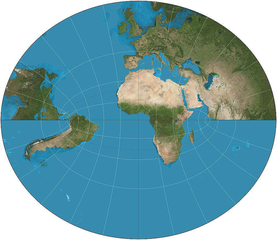
The Littrow projection is mathematically an azimuthal projection with extremely unusual graticule geometry. The central meridian and the meridian 90° away from it are straight lines; all other meridians are hyperbolas convex toward the central meridian. The equator is a straight line, while other parallels are ellipses with the equator as their major axis. The poles are not shown. The core property is conformal (preserves local angles) and anallactic: a straight line from any point on the map to the map center makes the same angle with the central meridian as the great-circle bearing between those two points on the globe. This comes at the cost of extreme area distortion, and the projection cannot depict the entire Earth—it is limited to a hemisphere or a region around a central point.
Pros
- Unique dual property: As the only projection that is both conformal and anallactic, the Littrow holds a special place in theoretical cartography, offering simultaneous local shape fidelity and true bearing from the map center.
- Precise directional reference: For applications that require knowing "which direction is the target from me?"—such as determining the direction of Mecca from any location or establishing bearings to a home port in early navigation—the Littrow projection provides unparalleled convenience.
- Central-point orientation: If a map is centered on a critical point (e.g., an astronomical observatory, military base, or transport hub), the projection accurately reflects true bearings from that center to anywhere on the map, which is valuable in military, telecommunication, and navigation contexts.
Cons
- Extreme area distortion: While preserving local angles, area distortion is severe. Regions far from the map center are enormously exaggerated in size, making the projection completely unsuitable for comparing landmass areas.
- Limited geographic coverage: The projection cannot show the whole world, nor even a full continent, without severe breakup and deformation at the edges. It is viable only for a hemisphere or a small region around the center point.
- Obscurity and poor software support: Unlike the Eckert VI, the Littrow projection is rarely found in modern GIS. It is not included as a standard option in major platforms such as ArcGIS, QGIS, or MapInfo. Most users would need custom mathematical implementations, limiting its practical accessibility.
- No polar representation: The poles are not shown on the map, which is a major drawback for any application involving high-latitude regions.
Application Scenario
Owing to its unique directional property, the Littrow projection is used in highly specialized, vertical applications. Its primary historical role was in 19th-century maritime and military cartography for determining bearings to a specific home port, flagship position, or colonial outpost. In modern times, it serves niche purposes such as religious maps (showing the direction of Mecca from anywhere in the world), astronomical orientation (determining azimuths of celestial objects), and telecommunications engineering (calculating point-to-point microwave or directional antenna bearings). It is almost never used for general-reference mapping, thematic global analysis, or geographic education. Instead, it remains a mathematical curiosity and a specialized directional tool in historical literature and specific calculation workflows.
Example
1. Littrow projection of partial hemisphere.
Related GIS Projections
Vertical Near-side Perspective Projection
Two-point Equidistant Projection