
 Service

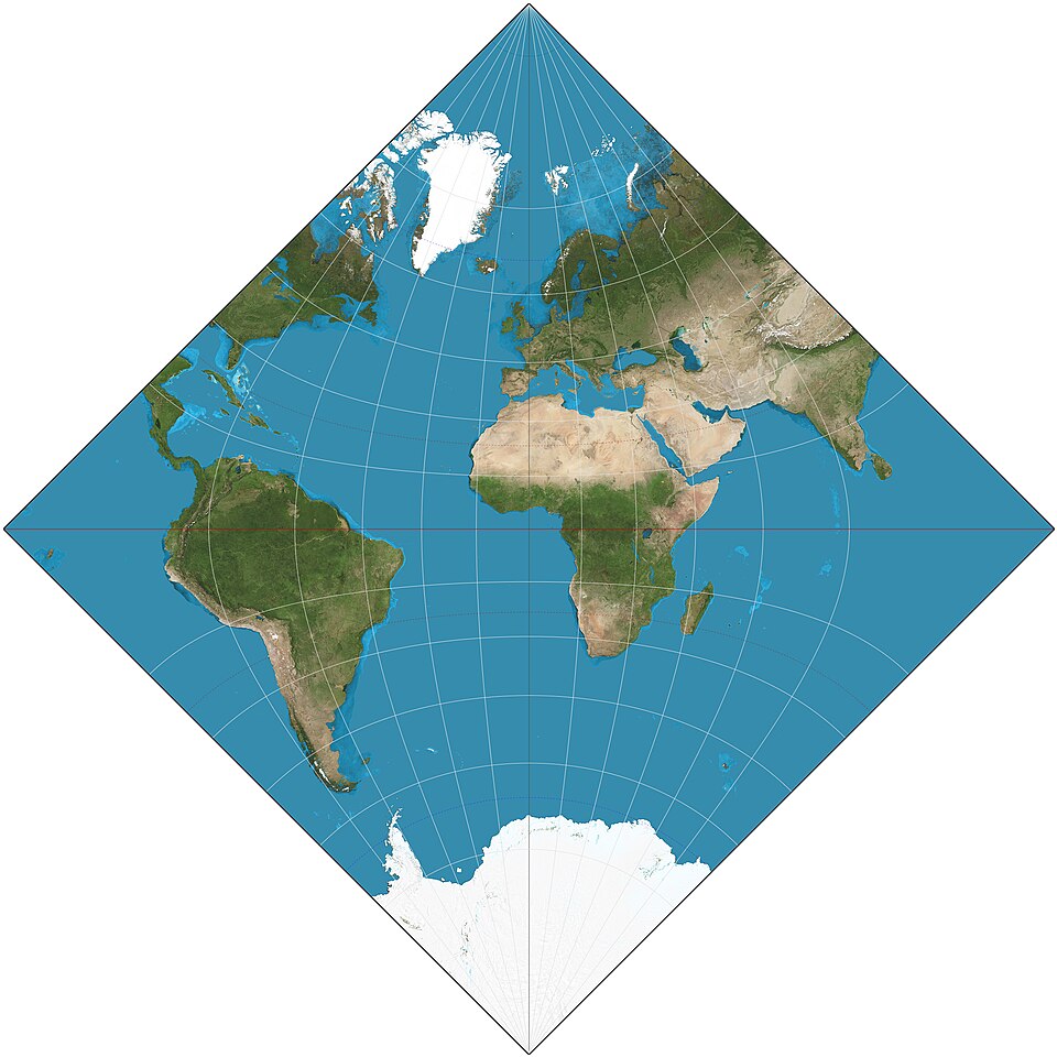
Adams World in a Square I Projection
Apr 14,2026
GISBox is a one-stop 3D GIS data editing, conversion and publishing platform that supports editing in multiple GIS formats such as OSGB/GEOTIFF/RVT, converting to 3DTiles/Terrain and publishing.
Introduction
Adams World in a Square I Projection is a conformal map projection developed by American mathematician and astronomer Oscar Sherman Adams in 1925. Adams, who worked at the U.S. Coast and Geodetic Survey, was a prolific contributor to theoretical cartography, known for his work on conformal projections and his adaptation of the Peirce quincuncial concept. The "World in a Square I" (often referred to as simply the Adams Square I projection) represents the Earth within a perfect square, with the poles located at two opposite corners. It is a member of the same conformal family as the Guyou and Peirce quincuncial projections, and like them, it relies on elliptical functions for its mathematical construction. The projection is notable for its ability to be tiled seamlessly in both directions, allowing the entire sphere to be represented without interruption in a compact, aesthetically striking square format.
Projection Basic
The Adams World in a Square I Projection is a conformal (equal-angle) projection that maps the entire globe onto a perfect square. The poles are positioned at two opposite corners of the square (typically the top-left and bottom-right, or the top-right and bottom-left), while the equator runs diagonally between the remaining two corners. The central meridian is represented as a straight line running through the center of the square. All parallels and meridians are complex curves derived from elliptical functions, specifically Jacobian elliptic functions, which give the projection its distinctive grid pattern. Unlike cylindrical or pseudocylindrical projections, the Adams Square I projection cannot be constructed by simple geometric formulas; it requires advanced mathematical techniques involving the transformation of spherical coordinates onto a plane using elliptic integrals. The projection is conformal everywhere except at the four corners, which represent singular points (the poles and two antipodal equatorial points).
Pros
- Strict conformality: As a conformal projection, Adams Square I preserves local angles and shapes with high fidelity. Small features maintain their correct form, making the projection theoretically sound for applications requiring local geometric accuracy.
- Compact square format: Unlike rectangular or circular world maps, the Adams Square I fits the entire Earth into a perfect square. This compact, symmetrical format is visually striking and can be aesthetically pleasing for decorative, artistic, or symbolic applications.
- Seamless tiling capability: The projection can be tiled infinitely in both horizontal and vertical directions without gaps or overlaps, creating a continuous, repeating pattern of the entire Earth. This property is unique among conformal world projections and has mathematical and artistic appeal.
- Uninterrupted representation: Unlike interrupted projections such as the Goode Homolosine, the Adams Square I presents the entire Earth's surface in a single, continuous image without cuts or breaks, preserving spatial continuity across the globe.
Cons
- Extreme area distortion: Being conformal, the projection severely exaggerates areas, particularly toward the corners of the square. Landmasses near the poles and along the diagonal boundaries appear heavily stretched and enlarged, making area comparisons completely unreliable.
- Severe shape distortion in peripheral regions: While conformality holds locally, the overall appearance of continents far from the center becomes highly distorted. Familiar shapes of continents become almost unrecognizable, especially near the corners, limiting the projection's utility for general-reference mapping.
- Extremely complex mathematics: The projection requires elliptical integrals and Jacobian elliptic functions for both forward and inverse transformations. This mathematical complexity makes it difficult to implement in standard GIS software, and computation can be slow and prone to precision issues.
- Poor software support: Unlike the Eckert VI or even the Littrow projection, the Adams Square I is not included as a standard option in mainstream GIS platforms such as ArcGIS, QGIS, or MapInfo. It exists primarily in specialized libraries (e.g., PROJ has limited support) and custom academic implementations, severely restricting its practical accessibility.
- Lack of intuitive interpretation: For most viewers unfamiliar with advanced conformal projections, the Adams Square I map is difficult to read and interpret. The placement of poles at corners and the unfamiliar graticule pattern disorient users, making it unsuitable for educational or general-audience mapping.
Application Scenario
The Adams World in a Square I Projection has almost no practical application in mainstream cartography, GIS analysis, or navigation. Its primary domain is theoretical and mathematical cartography, where it serves as an elegant example of conformal mapping using elliptic functions. The projection is occasionally used in academic research and mathematical demonstrations to illustrate the properties of Jacobian elliptic transformations and the concept of conformal tiling. In decorative cartography and artistic contexts, the striking square format and repetitive tiling capability have been employed for ornamental world maps, book covers, posters, and even textile patterns. Some niche applications include cryptography and spatial puzzles, where the projection's ability to map the sphere onto a square without interruption is exploited for theoretical purposes. However, for any practical geographic application—including population density mapping, climate modeling, navigation, resource management, or general-reference atlas production—the Adams Square I projection is almost never the appropriate choice, superseded by more practical equal-area, conformal (e.g., Mercator for navigation), or compromise projections (e.g., Robinson, Winkel Tripel).
Example
1. Adams hemisphere-in-a-square projection. 15° graticule.
Related GIS Projections
Vertical Near-side Perspective Projection
Two-point Equidistant Projection