 Service

New Zealand Map Grid Projection
Nov 24,2025
GISBox is a one-stop 3D GIS data editing, conversion and publishing platform that supports editing in multiple GIS formats such as OSGB/GEOTIFF/RVT, converting to 3DTiles/Terrain and publishing.
Introduction
New Zealand Map Grid Projection is a conformal map projection technology specifically designed for large-scale mapping of New Zealand. It employs the complex Cauchy-Riemann equations for projection calculations, with its central point set at 173° East longitude and 41° South latitude. It is important to note that this projection method is only suitable for large-scale mapping within New Zealand and may not be applicable for mapping other regions.
Projection Basic
The New Zealand Map Grid is a conformal cylindrical projection specifically designed for large-scale mapping of New Zealand. Utilizing the Cauchy-Riemann equations algorithm and centered at 173° East and 41° South, its meridians and parallels are projected as sixth-order complex algebraic polynomial curves. This maintains minimal distortion in direction, angles, and shape, with areal error below 0.04% and scale deviation controlled within 0.02%. The projection is exclusively suitable for mainland New Zealand, as use in other regions would result in significant distortion.
Pros
- Conformal Properties: The application of the Cauchy-Riemann equations algorithm ensures preservation of local shapes, directions, and angles, making it suitable for engineering surveys and precision measurement requirements.
- Optimized Design: Centered at 173° East and 41° South, it is specifically optimized for New Zealand's topography, resulting in minimal distortion in central regions.
- Large-Scale Applicability: Designed specifically for large-scale mapping of New Zealand, it effectively maintains geometric accuracy to meet cartographic and surveying requirements.
Cons
- Geographical Limitations: Only applicable to mainland New Zealand (North Island, South Island, and Stewart Island); use in other regions leads to significant distortion.
- Edge Distortion: Distortion increases with distance from the central point, affecting measurement accuracy in peripheral areas.
- Technical Replacement: It has been superseded by the New Zealand Transverse Mercator 2000 (NZTM2000), and some modern applications may require additional conversion parameters.
Application Scenario
The New Zealand Map Grid (NZMG) projection is a conformal projection specifically designed for large-scale mapping of New Zealand, primarily used for engineering surveys, land planning, and Geographic Information System (GIS) mapping within the country. Its conformal properties ensure minimal distortion in direction, angles, and shape (areal error <0.04%), making it suitable for scenarios requiring high-precision measurements such as topographic mapping, infrastructure construction, and natural resource management. Optimized through the Cauchy-Riemann equations algorithm and centered at 173° East and 41° South, with meridians and parallels represented as sixth-order complex algebraic polynomial curves, the projection exhibits extremely low distortion in central regions. However, its use must be strictly limited to mainland New Zealand (North Island, South Island, and Stewart Island), as application in other regions or for small-scale mapping would result in significant distortion compromising accuracy.
Example
1. This displays a grid projection of a New Zealand map centered on New Zealand.
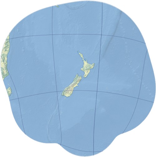
2. New Zealand map grid (EPSG: 27200).
Related GIS Projections
Transverse Mercator Projection
Longitude / Latitude Projection