
Longitude / Latitude Projection
GISBox is a one-stop 3D GIS data editing, conversion and publishing platform that supports editing in multiple GIS formats such as OSGB/GEOTIFF/RVT, converting to 3DTiles/Terrain and publishing.
Introduction
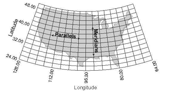
Longitude / Latitude Projection uses the longitude and latitude coordinate system of the earth, usually in degrees. The basic principle is to imagine a cylinder that is consistent with the direction of the earth’s axis and cuts or severing the earth, project the longitude and latitude grid onto the cylindrical surface according to the equiangular condition, and then unfold the cylindrical surface into a plane to obtain a plane longitude and latitude grid. After projection, the meridians are a set of vertical equidistant parallel straight lines, and the latitudes are a set of parallel straight lines perpendicular to the meridians. The interval between adjacent latitudes increases from the equator to the poles.
Data Format Overview
**Earth ellipsoid: **The true shape of the earth is close to an ellipsoid, so when performing longitude and latitude projection, the earth is usually treated as an ellipsoid.
Longitude and latitude coordinate system: Longitude represents the angle between a point on the earth’s surface and the earth’s prime meridian, usually expressed in degrees (°), ranging from 0° to 360°; latitude represents the angle between a point on the earth’s surface and the earth’s equatorial plane, also expressed in degrees (°), ranging from 0° (equator) to 90° (North Pole or South Pole).
Projection surface: Longitude and latitude projection requires a plane as the projection surface, and the points on the earth’s ellipsoid are projected onto this plane according to certain rules.
Pros
**1. Maintaining angles and directions: **Longitude and latitude projections can maintain the angles and directions of geographic information, which is particularly important for fields such as astronomy and navigation that require accurate representation of directions.
**2. Global applicability: **The longitude and latitude coordinate system is universally used, so longitude and latitude projections are also universally used, facilitating international communication and cooperation.
Cons
1. Deformation problem: The longitude and latitude projection has a larger deformation in the areas far from the equator on the map, which may cause the shape on the map to deviate from the actual shape.
2. Not suitable for large-scale mapping: Due to the deformation problem, the longitude and latitude projection is usually not suitable for large-scale mapping, especially in high-latitude areas.
Application Scenario
Longitude / Latitude projection is widely used in many fields, but is used in astronomy, navigation, and some scientific research fields. In these fields, the longitude and latitude coordinates of the earth need to be accurately represented for astronomical observation, navigation, and scientific research.
Example
- Latitude and Longitude Coordinates.
- Longitude / Latitude projection.

Related GIS Projections
Transverse Mercator Projection