 Service


DHDN (Deutsches Hauptdreiecksnetz)
DHDN (Deutsches Hauptdreiecksnetz) is the old national geodetic datum of the Federal Republic of Germany, corresponding to EPSG code 4314. It is also often referred to as the Lauenberg Datum or Potsdam Datum. Based on the Bessel 1841 ellipsoid, its original fundamental point was TP Lauenberg. After this point was destroyed by sand and gravel extraction, the Helmert Tower in Potsdam became the new central point. DHDN served as the common coordinate basis for land surveying in the old federal states of Germany. With the advent of satellite geodetic techniques, the importance of the hierarchical triangulation network gradually declined. Starting in the 2010s, DHDN has been replaced by the ETRS89 coordinate system. Today, it is mainly used for onshore geodetic surveying and national digital mapping in the former West German states, covering areas such as Baden-Württemberg and Bavaria.
2026-06-12 15:54:25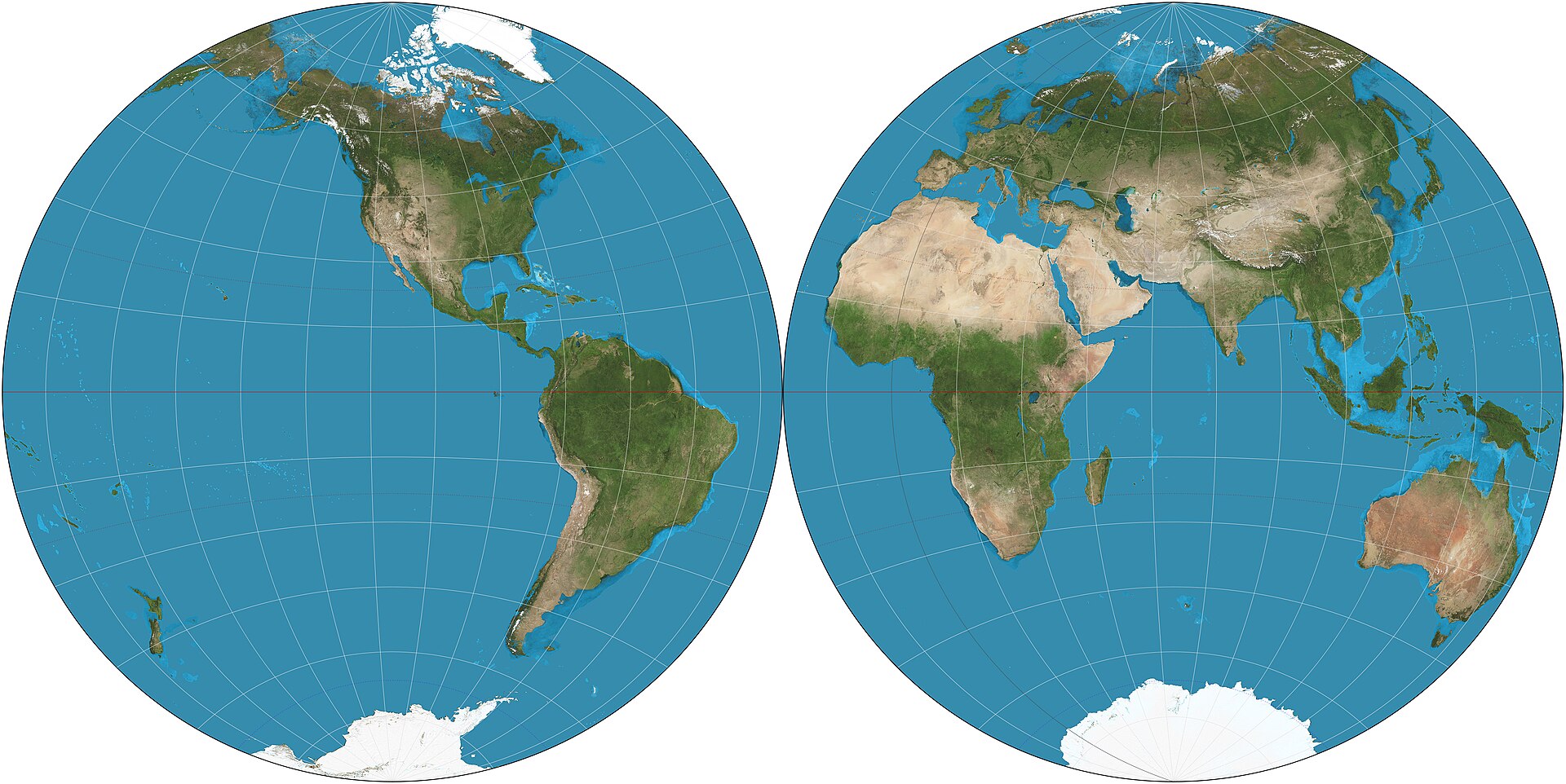
Nicolosi Globular Projection
Nicolosi Globular Projection is a pseudocylindrical compromise world map projection introduced by the Italian cartographer Giambattista Nicolosi in 1660. It is one of the best-known early globular projections and was widely used before modern mathematical projections became standard. The projection represents the world in a rounded form and was valued for its visually balanced appearance. It is neither equal-area nor conformal, and today it is mainly of historical interest.
2026-05-28 17:41:15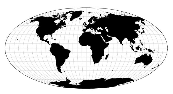
Apian Globular Projection
Apian Globular Projection is a pseudocylindrical world map projection introduced by Peter Apian in the 16th century. It belongs to the family of early globular projections developed during the Renaissance, when cartographers sought visually appealing ways to represent the whole world. The projection is neither equal-area nor conformal, but it was valued for its balanced appearance and for presenting the world in a rounded, compact form. Today it is mainly of historical interest.
2026-05-28 17:37:14
Airy Projection
Airy Projection is an azimuthal map projection devised by the British astronomer and mathematician Sir George Biddell Airy in 1861. It is designed as a compromise projection, intended to reduce overall distortion within a circular map, especially when the region of interest is centered on the projection point. Unlike equal-area or conformal projections, the Airy projection does not preserve any single property perfectly, but instead seeks a visually balanced representation. It is mainly of historical and theoretical interest and is sometimes used for hemispheric maps.
2026-05-28 17:30:24
Adams World in a Square II Projection
Adams World in a Square II Projection is a conformal map projection developed by American mathematician Oscar Sherman Adams of the U.S. Coast and Geodetic Survey and presented in 1925. It is one of two projections (alongside Adams World in a Square I) that map the entire sphere onto a perfect square. In Adams's original design, the equator and central meridian are displayed as the diagonals of the square, with the poles projecting as points in opposite corners. The projection preserves conformality everywhere except at the four corners of the square. A notable property is its ability to be tessellated or mosaicked, enabling the creation of continuous repeating patterns. This projection (or a very similar one) was used in 1979 by Athelstan Spilhaus, with assistance from Robert Hanson and Ervin Schmid of the National Geodetic Survey, for his world ocean map.
2026-05-26 16:22:21
OpenDRIVE (.xodr)
OpenDRIVE (.xodr) is an open standard file format used to describe static road networks in autonomous driving simulation. Based on the XML structure, it can precisely represent critical information such as road geometry, lane layout, and traffic signs. Maintained by the ASAM organization, it is primarily used in high‑definition maps and driving simulators, supporting data exchange between different simulation platforms and ensuring high realism and interoperability when testing and validating autonomous driving systems in virtual environments.
2026-05-25 13:46:15
SDTS (Spatial Data Transfer Standard)
SDTS (Spatial Data Transfer Standard) is a spatial data exchange standard developed in the United States, designed to enable lossless conversion of geographically referenced data between different computer systems. By defining a unified three‑layer model (conceptual, logical, and format), it ensures the integrity of vector and raster data during transmission and supports the simultaneous exchange of metadata. The standard was confirmed as a U.S. Federal Information Processing Standard (FIPS 173) in July 1992. Led by the U.S. Geological Survey (USGS), SDTS has been widely used for spatial data sharing among federal agencies, local governments, and commercial organizations.
2026-05-25 13:41:51
SOSI (Systematic Organization of Spatial Information)
SOSI (Systematic Organization of Spatial Information) is Norway‘s national geographic information exchange standard. It is widely used for geospatial data sharing and exchange among Norwegian government agencies and industries. SOSI supports the structured storage of various types of spatial information, including terrain, roads, water systems, and more. It serves as an important foundational format in Norway’s GIS domain and is still in use by official mapping authorities, although there are plans to transition to international standards such as GML in the future.
2026-05-25 13:36:42
SpatiaLite (.sqlite)
SpatiaLite (.sqlite) is an extension module for the SQLite database that adds support for geospatial data to SQLite. It enables the storage, querying, and analysis of geometric objects such as points, lines, and polygons, and provides full spatial indexing and spatial functions (e.g., distance calculation, intersection testing, buffer analysis). Thus, it implements lightweight, serverless spatial database functionality within a single .sqlite file, making it suitable for geographic information processing needs in mobile applications, desktop tools, and embedded systems.
2026-05-25 13:29:10
WKB (Well-Known Binary)
WKB (Well-Known Binary) is a binary encoding standard defined by the Open Geospatial Consortium (OGC) for representing geometric objects. It stores spatial features such as points, lines, and polygons as a compact byte stream. Compared to the text‑based WKT format, WKB offers higher storage efficiency and faster transmission and parsing speeds. Its structure typically consists of a 1‑byte byte order marker (0x01 for little‑endian), a 4‑byte geometry type code (e.g., Point = 1, LineString = 2), followed by coordinate data. Coordinates are arranged as IEEE 754 double‑precision floating‑point numbers. WKB is widely used as the underlying storage format for geometry fields in spatial databases such as PostGIS and MySQL.
2026-05-25 13:24:10