
 Service

Routing API
Reverse Geocoding API is a technical interface that converts longitude and latitude coordinates into human-readable addresses. It automatically returns the corresponding structured address information (such as "Tiananmen Square, Dongcheng District, Beijing") by inputting GPS coordinates (such as 116.404,39.915), and supports the attachment of surrounding POI (points of interest) data. This service is widely used in map navigation, logistics tracking, location analysis and other scenarios, and is one of the core components of LBS (location-based services).
2025-11-05 14:19:20_1762323506153.png)
Reverse Geocoding API
Reverse Geocoding API is a technical interface that converts longitude and latitude coordinates into human-readable addresses. It automatically returns the corresponding structured address information (such as "Tiananmen Square, Dongcheng District, Beijing") by inputting GPS coordinates (such as 116.404,39.915), and supports the attachment of surrounding POI (points of interest) data. This service is widely used in map navigation, logistics tracking, location analysis and other scenarios, and is one of the core components of LBS (location-based services).
2025-11-05 14:17:26
_1762323273719.png)
LandsatLook Viewer API - USGS Landsat Satellite Imagery Service
USGS Landsat Look Viewer API is an online tool provided by the United States Geological Survey (USGS) that allows users to browse and download Landsat satellite images since 1972, supporting multiple data types and advanced query functions. LandsatLook Viewer API aims to provide Geographic Information System (GIS) users with an efficient and convenient way to obtain and analyze Landsat images, and is an important tool for remote sensing research and environmental monitoring. Users can obtain more detailed instructions and development support by reading the official documentation.
2025-11-05 14:12:20_1762322965999.png)

3D Studio
3D Studio Max is a PC-based 3D modeling, rendering and animation software developed by Discreet. It was originally named 3D Studio and later released as 3D Studio Max on the Windows NT platform. The software provides a wealth of functions, including modeling, animation, rendering, and collaboration with other software. The latest version is 2024, supports multiple operating systems, and has multi-language capabilities.
2025-11-05 14:07:47_1762322863288.png)
GeoPDF (Geospatial PDF)
GeoPDF embeds geographic spatial information (such as latitude and longitude coordinates and coordinate reference systems) in standard PDF files, enabling ordinary PDF readers (such as Adobe Reader) to support geographic location viewing, map navigation, and basic geographic analysis functions, combining the portability of PDF with the data analysis capabilities of GIS.
2025-11-05 14:07:10
S57 (Standard for Electronic Navigational Charts)
S57 (Standard for Electronic Navigational Charts) is an international standard developed by the International Hydrographic Organization (IHO) for the exchange and display of electronic nautical chart data, primarily used in marine navigation systems. It standardizes the format, structure, and content of chart data, ensuring interoperability between electronic nautical chart systems from different manufacturers, providing ships with accurate and unified critical navigation information such as water depth, channel, and obstacles. In short, S57 is the "universal language" of electronic nautical charts, ensuring safe and efficient maritime navigation.
2025-11-05 14:05:55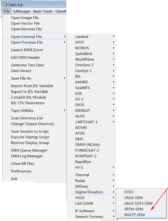
CNSDTF (China National Standard Geospatial Data Exchange Format)
CNSDTF (China National Standard Geospatial Data Exchange Format) is a national standard for geographic information system (GIS) data exchange in China. It unifies the storage and transmission formats of spatial data, such as vector and raster data, and addresses data compatibility issues across different platforms. Its core goal is to enable efficient cross-system sharing through structured file headers, feature parameters, and separated geometry/attribute data. It is widely used in fields such as land planning and environmental monitoring.
2025-11-05 14:05:07
LVB (SuperMap proprietary format)
LVB is a proprietary geospatial data format developed by Beijing SuperMap Software Company, primarily used for storing and managing vector map data. Optimized for the SuperMap GIS platform, it supports efficient spatial data compression and fast retrieval, making it a popular choice for professional geographic information system applications in areas such as land planning and smart cities. It boasts strong compatibility and seamless integration with the SuperMap suite of software.
2025-11-05 14:03:56