 Service

RVM (AVEVA Review Model)
RVM is a 3D model data storage format developed by the British company AVEVA for the Plant Design Management System (PDMS). It is mainly used to store 3D model information such as pipelines, equipment, and structures of factory facilities (such as petrochemical plants and power stations). It supports both text (TextRVM) and binary (BinaryRVM) formats, the latter of which is more common and has higher storage efficiency.
2025-09-16 14:48:19
SketchUp
SketchUp is a 3D modeling software developed by Trimble, with the core concept of “making 3D modeling as natural as sketching with a pencil”. It significantly lowers the threshold of 3D design through a minimalist interface and intuitive push-pull modeling tools (such as drawing lines to create surfaces and extruding to create bodies), and is suitable for quickly building solution prototypes in the fields of architecture, interior design, and landscape. Its unique advantage lies in the balance between professionalism and ease of use. 80% of users can master basic operations within 3 hours.
2025-09-16 14:48:19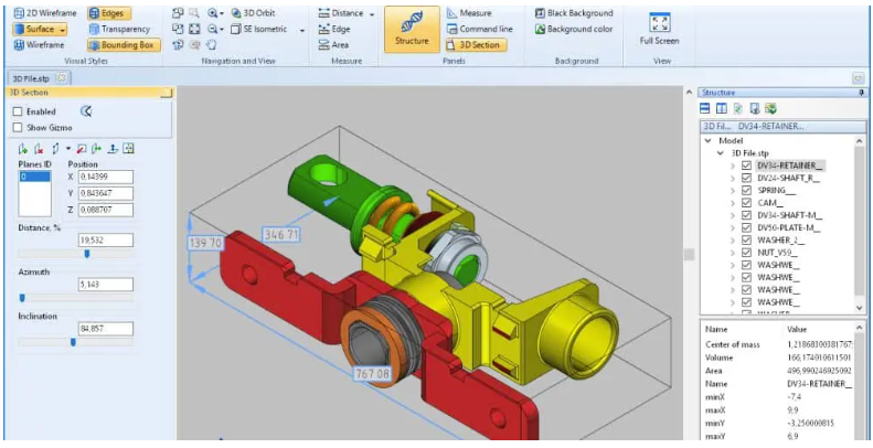
STEP (Product Model Data)
The full name of STEP is Standard for the Exchange of Product Model Data. It is an international standard 3D CAD data exchange format. The standard number is IS10303. STEP file is an internationally used 3D model data exchange format. The extension is usually step or .stp. It can share data between different CAD software, which is very convenient.
2025-09-16 14:48:20
GRIB (GRIDded Binary)
GRIB (GRIDded Binary) is a standard file format for storing and transmitting meteorological data, designed by the World Meteorological Organization (WMO). It is mainly used to describe rasterized meteorological data, such as temperature, humidity, wind speed, precipitation, etc. GRIB files store data in binary form, which is efficient and has a high compression rate, so it has become one of the main data formats in the meteorological field.
2025-09-16 19:22:05
VRML (Virtual Reality Modeling Language)
VRML is the abbreviation of Virtual Reality Modeling Language. It was created mainly to solve the problem of realizing 3D animation effects and user interaction based on 3D objects in web pages. VRML files are usually used to describe 3D virtual environments, containing information such as vertices, edges, and colors of polygons. Using VRML, developers can create interactive 3D scenes that can be displayed on web pages. VRML files use the extension .wrl (world file) and are stored in text format, which has good readability and is easy to edit manually.
2025-09-16 19:31:28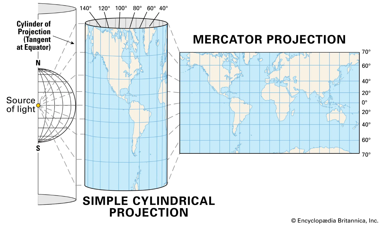
Mercator Projection
Mercator Projection is one of the most famous map projections. It was first proposed by Franz Walter Mercator (Gerardus Mercator) in 1569 and is mainly used for drawing nautical charts. Mercator projection is a kind of orthogonal cylindrical projection, also known as “standard cylindrical projection”. Its characteristic is that it can project the longitude and latitude coordinates of the earth onto a plane, keeping the angle unchanged, so it is very useful in navigation and aviation.
2025-09-16 14:46:58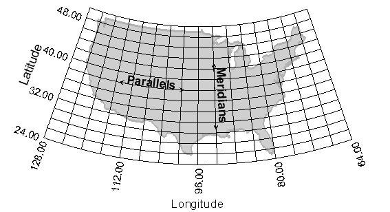
Longitude / Latitude Projection
Longitude / Latitude Projection uses the longitude and latitude coordinate system of the earth, usually in degrees. The basic principle is to imagine a cylinder that is consistent with the direction of the earth’s axis and cuts or severing the earth, project the longitude and latitude grid onto the cylindrical surface according to the equiangular condition, and then unfold the cylindrical surface into a plane to obtain a plane longitude and latitude grid. After projection, the meridians are a set of vertical equidistant parallel straight lines, and the latitudes are a set of parallel straight lines perpendicular to the meridians. The interval between adjacent latitudes increases from the equator to the poles.
2025-09-16 14:46:58
Web Mercator (Pseudo Mercator, EPSG:3857)
Pseudo Mercator projection is a sphere-based conformal cylindrical projection. It converts longitude and latitude coordinates into plane rectangular coordinates by approximating the earth as a sphere and using a tangent cylindrical projection. It is widely used in global Web map services (such as Google Maps and OpenStreetMap) and supports seamless splicing and layered tile loading.
2025-09-16 14:46:59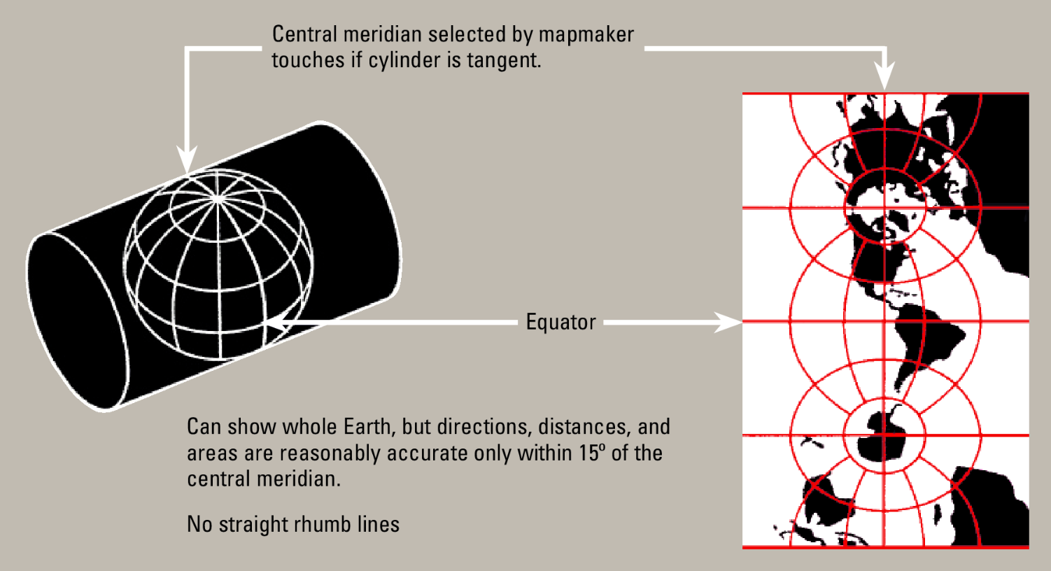
Transverse Mercator Projection
Transverse Mercator projection is a conformal cross-cylindrical projection that cuts the Earth ellipsoid along the meridian (central meridian) and unfolds it into a plane. It is widely used in large-scale topographic mapping and national coordinate systems (such as the UTM coordinate system) in mid-latitude regions.
2025-09-16 14:46:59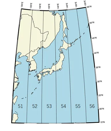
UTM (Universal Transverse Mercator)
UTM projection (Universal Transverse Mercator) is a coordinate system that divides the earth’s surface into zones and applies the Transverse Mercator projection to each zone. By dividing the earth into 60 zones, each zone is 6 degrees longitude apart, and projecting independently in each zone, high-precision plane rectangular coordinates can be obtained.
2025-09-16 14:46:59