 Service


Polar Stereographic (Elliptical) Projection
Polar Stereographic (Elliptical) Projection is a conformal projection centered on the poles, formed by orthographically projecting the Earth's surface from the pole onto a plane. The meridians appear as radiating straight lines, and the parallels appear as concentric circles (or circular arcs). By employing elliptical parameters, it more accurately matches the Earth's ellipsoidal shape, maintaining relatively low distortion in polar regions. It is commonly used for polar map production and navigation.
2026-06-18 14:05:38
Bertin 1953 Projection
Bertin 1953 Projection is an equal-area world map projection designed by French cartographer Jacques Bertin in 1953. Its core objective is to accurately represent the relative areas of countries and regions worldwide, making it particularly suitable for visualizing socio-economic data. The projection achieves strict area proportionality by highly compressing polar regions and deforming the entire Earth's surface into an approximately elliptical shape, with both meridians and parallels appearing as smooth curves. Although it does not preserve shape (non-conformal) or distance (non-equidistant), it maintains strict equal-area properties, achieving good overall visual balance and regional comparability. It remains one of the important non-traditional projections in modern thematic cartography.
2026-06-18 14:01:46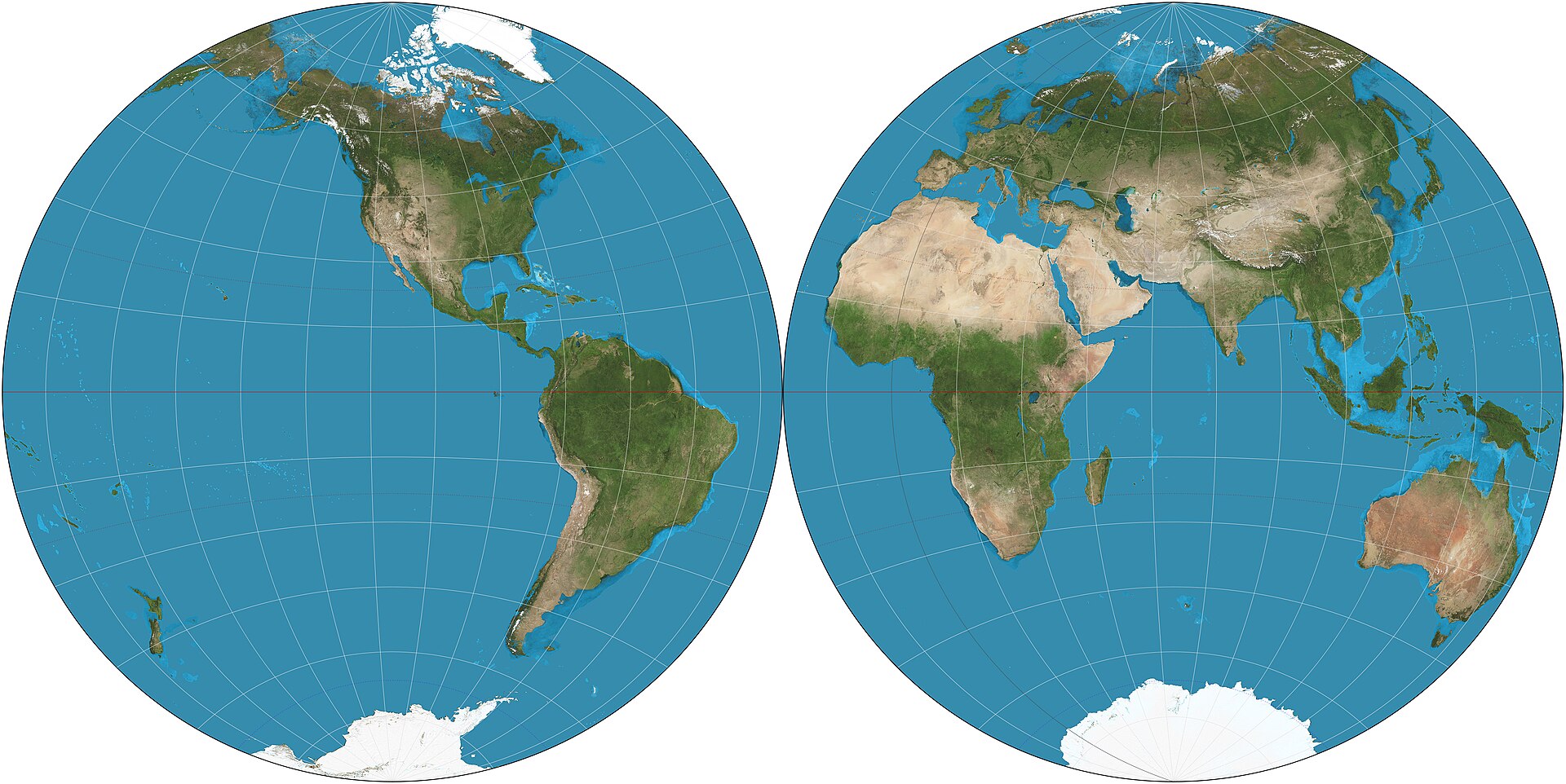
Nicolosi Globular Projection
Nicolosi Globular Projection is a pseudocylindrical compromise world map projection introduced by the Italian cartographer Giambattista Nicolosi in 1660. It is one of the best-known early globular projections and was widely used before modern mathematical projections became standard. The projection represents the world in a rounded form and was valued for its visually balanced appearance. It is neither equal-area nor conformal, and today it is mainly of historical interest.
2026-05-28 17:41:15
Apian Globular Projection
Apian Globular Projection is a pseudocylindrical world map projection introduced by Peter Apian in the 16th century. It belongs to the family of early globular projections developed during the Renaissance, when cartographers sought visually appealing ways to represent the whole world. The projection is neither equal-area nor conformal, but it was valued for its balanced appearance and for presenting the world in a rounded, compact form. Today it is mainly of historical interest.
2026-05-28 17:37:14
Airy Projection
Airy Projection is an azimuthal map projection devised by the British astronomer and mathematician Sir George Biddell Airy in 1861. It is designed as a compromise projection, intended to reduce overall distortion within a circular map, especially when the region of interest is centered on the projection point. Unlike equal-area or conformal projections, the Airy projection does not preserve any single property perfectly, but instead seeks a visually balanced representation. It is mainly of historical and theoretical interest and is sometimes used for hemispheric maps.
2026-05-28 17:30:24
Adams World in a Square II Projection
Adams World in a Square II Projection is a conformal map projection developed by American mathematician Oscar Sherman Adams of the U.S. Coast and Geodetic Survey and presented in 1925. It is one of two projections (alongside Adams World in a Square I) that map the entire sphere onto a perfect square. In Adams's original design, the equator and central meridian are displayed as the diagonals of the square, with the poles projecting as points in opposite corners. The projection preserves conformality everywhere except at the four corners of the square. A notable property is its ability to be tessellated or mosaicked, enabling the creation of continuous repeating patterns. This projection (or a very similar one) was used in 1979 by Athelstan Spilhaus, with assistance from Robert Hanson and Ervin Schmid of the National Geodetic Survey, for his world ocean map.
2026-05-26 16:22:21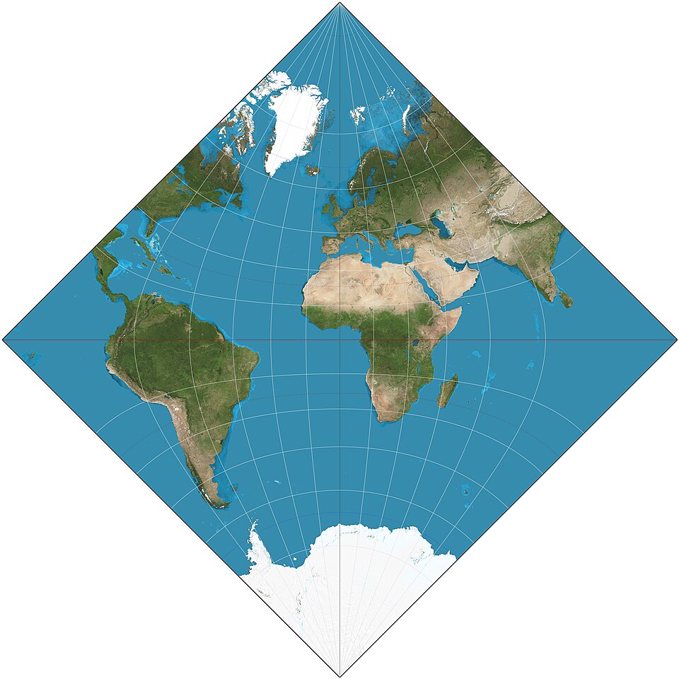
Adams World in a Square I Projection
Adams World in a Square I Projection is a conformal map projection developed by American mathematician and astronomer Oscar Sherman Adams in 1925. Adams, who worked at the U.S. Coast and Geodetic Survey, was a prolific contributor to theoretical cartography, known for his work on conformal projections and his adaptation of the Peirce quincuncial concept. The "World in a Square I" (often referred to as simply the Adams Square I projection) represents the Earth within a perfect square, with the poles located at two opposite corners. It is a member of the same conformal family as the Guyou and Peirce quincuncial projections, and like them, it relies on elliptical functions for its mathematical construction. The projection is notable for its ability to be tiled seamlessly in both directions, allowing the entire sphere to be represented without interruption in a compact, aesthetically striking square format.
2026-04-14 19:15:55
Guyou Projection
Guyou projection is a conformal map projection proposed by French mathematician and naval captain Émile Guyou in 1886. As a member of the French Academy of Sciences (elected 1894) and a recipient of the Légion d'Honneur, Guyou developed this projection as an elegant solution for displaying the world in a rectangular form while preserving local angles. The projection belongs to the same family as the Peirce quincuncial projection—in fact, the Guyou and Peirce projections are transverse cases of each other: Guyou represents the equatorial aspect, while Peirce represents the polar aspect. Though mathematically complex, relying on elliptical integrals for its computation, the Guyou projection offers the unique ability to be tiled infinitely, allowing any point on Earth to be connected to any other by a straight line.
2026-04-14 19:10:48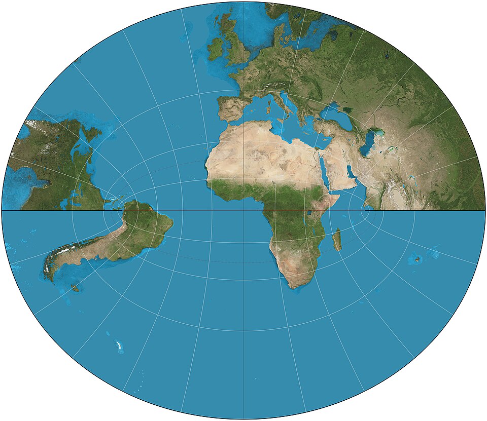
Littrow Projection
Littrow Projection is a unique conformal retroazimuthal map projection proposed by Austrian astronomer and cartographer Joseph Johann von Littrow in 1833. It stands out as the only map projection that combines both conformal and retroazimuthal properties, a rare dual characteristic that distinguishes it from all other projection designs. Later independently reinvented by British Merchant Navy’s Patrick Weir in 1890, it is also occasionally referred to as the Weir Azimuth Diagram. Unlike global projections designed for world maps, the Littrow Projection is specialized for directional measurement, presenting a limited geographic scope with hyperbolic meridians and elliptical parallels. It cannot display the entire globe, focusing instead on preserving local angles and accurate azimuths toward a predefined central point.
2026-04-14 19:03:51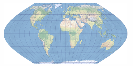
Eckert VI Projection
Eckert VI Projection is a pseudocylindrical equal-area map projection proposed by German cartographer Max Eckert in 1906. As the sixth and most widely recognized projection in the Eckert series, it represents a significant departure from the earlier Eckert I–V designs. Unlike its predecessors, Eckert VI features equally spaced straight parallels and curved meridians that are elliptical arcs, with the central meridian appearing as a straight line half the length of the equator. The poles are represented as points (rather than lines), creating a more conventional and visually appealing world map while maintaining strict equal-area properties. This projection is often compared favorably to the Robinson projection in terms of aesthetic balance.
2026-04-03 15:47:54