 Service


Alembic
Alembic is an open source geometry cache file format and related software tools widely used in the field of computer graphics. It is mainly used to efficiently transmit and exchange complex geometric data, especially animation and simulation data, between different 3D software and renderers. It is also gradually emerging in the field of geographic information systems (GIS). It can accurately store the vertex positions, animation keyframes, deformation information, etc. of 3D models, and has good compression performance, which can effectively reduce the amount of data and improve data transmission and storage efficiency.
2025-09-16 14:48:11
CIS/2 (CIMSteel Integration Standards)
CIS/2 stands for CIMSteel Integration Standards (Computer Integrated Manufacturing Building Steel Structure Standards), which is a file format used for information exchange and storage in the field of building steel structures. It aims to create a seamless and integrated information flow for building steel structure project information, covering everything from nuts and bolts to materials, loads, frames and components. This format can represent the structure as an analysis, design or manufacturing (detailed) model, and is widely used in the design, analysis, procurement, manufacturing planning, automated manufacturing and installation of steel structures in the construction industry.
2025-09-16 14:48:11
3ds Max (3D Studio Max)
3ds Max (3D Studio Max) is a professional 3D computer graphics software developed by Autodesk, mainly used in 3D modeling, animation production, game development, film and television special effects and architectural visualization. As an industry-leading 3D design tool, its functions cover the entire process from concept design to final rendering, supporting polygon modeling, NURBS surfaces, skeletal animation system, physical simulation and advanced rendering engine, and is widely used in creative industries such as entertainment, engineering, and advertising.
2025-09-16 14:48:10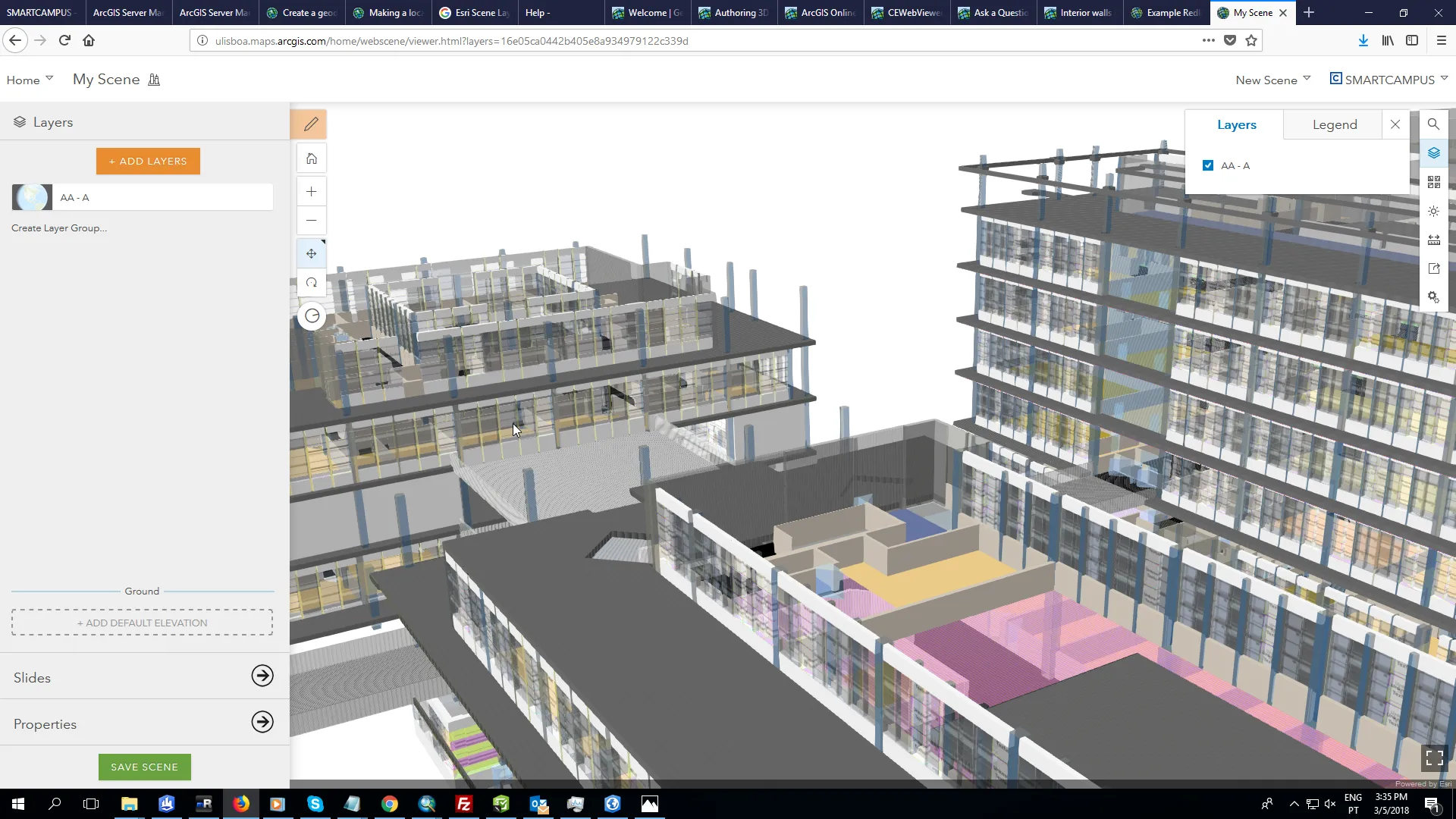
SLPK (Scene Layer Package)
SLPK (Scene Layer Package) file format is a file format used to store and share 3D scene data. The SLPK file is a packaging format in ArcGIS Pro software, which is used to package 3D scene data and related resources into a single file for easy sharing and transmission on the ArcGIS platform.
2025-09-16 14:48:09
Bentley
Bentley Systems is a world-leading infrastructure engineering software company. Its GIS solutions are centered on the deep integration of “BIM+GIS” and provide full life cycle management tools for smart cities, transportation, energy, water conservancy and other fields. Bentley GIS product matrix includes MicroStation (3D modeling engine), ProjectWise (collaborative work platform), ContextCapture (real scene modeling), OpenRoads/OpenRail (transportation infrastructure design), etc. Its core technologies cover the construction of 2D and 3D integrated data models, real-time collaborative updates in the cloud, integrated processing of multi-source data (CAD/BIM/GIS/remote sensing), spatial analysis decision support, and full life cycle data management system.
2025-09-16 14:48:09

VTPK (Vector Tile Package)
VTPK (Vector Tile Package) is a vector tile data format proposed by Esri. It is built based on vector data compression and slicing technology. It realizes efficient storage and transmission by decomposing geospatial data into multi-level pyramid structured vector tiles (PBF format). Its core features include multi-resolution support, vector data-based compression algorithm, cross-platform compatibility and offline use capability. It is suitable for mobile navigation, geographic information collection, outdoor survey and other scenarios.
2025-09-16 14:48:08
Revit File
Revit files are design files created using Revit, a BIM (Building Information Modeling) software developed by Autodesk. It is unique in its ability to integrate and manage 3D models and design information used in the fields of architecture, structure, and engineering (MEP). It is widely used in the construction industry around the world and is a core component of the BIM workflow that covers the entire life cycle from building design to construction and maintenance.
2025-09-16 14:48:07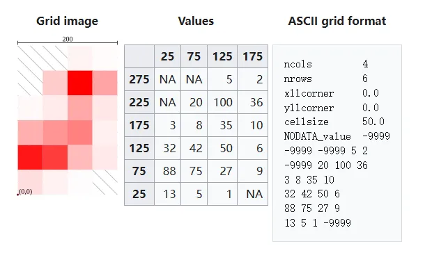
Esri Grid
Esri Grid is a type of raster data format developed by the Environmental Systems Research Institute (ESRI) in the United States. It is a format that is mainly used as a standard in the ArcGIS product group and is used to divide geospatial information into a grid and manage it. Numerical information (elevation value, classification code, etc.) is stored in each cell, and it is used in a wide range of GIS (geographic information system) applications such as topographic analysis, land use classification, and climate data analysis.
2025-09-16 14:48:07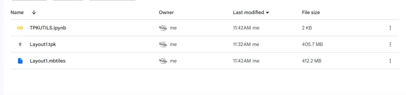
TPK (Tile Package)
TPK (Tile Package) file is a file format for packaging raster or vector map tiles used by ESRI’s ArcGIS platform. It is mainly used for viewing maps offline or embedding maps in applications, and the extension is “.tpk”. Tiles are a collection of images that divide a map or aerial photo into different zoom levels, and TPK is a single compressed file containing all these images.
2025-09-16 14:48:06