 Service


TopoJSON (Topology JSON Format)
TopoJSON (Topology JSON Format) is a JSON-based vector data format designed to efficiently represent geospatial data. Proposed by American data visualization researcher Mike Bostock, it extends the standard GeoJSON format and is characterized by explicitly preserving the topology (adjacency relationships and shared boundaries) of geographic data. TopoJSON adopts a structure where boundary lines shared among multiple geographic objects are stored only once and then referenced, enabling significant data size reduction. Therefore, it is widely used in scenarios requiring lightweight, high-speed geographic data delivery, such as web maps and data visualization.
2026-04-28 14:14:36
Parquet / GeoParquet
Parquet / GeoParquet is a cloud-native data format built on Apache Parquet, a columnar data format, extended to efficiently store and process geospatial data. GeoParquet adds metadata specifications for handling geospatial information and is designed to enable high-speed processing of large-scale spatial data in cloud environments and distributed processing platforms. It is primarily used in environments such as big data analytics, cloud GIS, and geospatial data lakes, and is recognized as a next-generation geospatial data format gaining attention within the Open Geospatial Consortium (OGC) community.
2026-04-28 14:00:33
COLLADA / DAE (Digital Asset Exchange)
COLLADA / DAE is an open standard 3D data format designed for the exchange of 3D models and digital assets. Managed by the Khronos Group, it is XML-based and can describe 3D geometry, materials, textures, animations, scene structures, and more. It is widely used as a "neutral exchange format" enabling data interoperability between different software applications in game engines, 3D CG production tools, BIM, and the 3D GIS field.
2026-02-27 15:12:56
GXT
GXT / MapInfo Custom Coordinate System File is a text-based format used in MapInfo Professional to define custom map projections, coordinate systems, and datum transformations. Managed as part of MapInfo's spatial data management ecosystem, it enables users to extend beyond predefined coordinate systems by creating custom definitions tailored to specific local surveying needs, specialized datasets, or regional mapping requirements. It serves as an essential configuration tool for ensuring spatial data aligns correctly across different maps and layers.
2026-02-28 15:28:51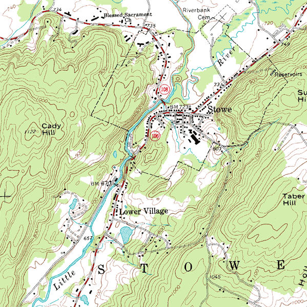
DRG (Digital Raster Graphic)
DRG (Digital Raster Graphic) is a raster data format created by scanning paper topographic maps at high resolution and adding georeferencing information. Primarily produced by the United States Geological Survey (USGS) through digitization of topographic maps, it preserves map information such as contour lines, roads, hydrography, and administrative boundaries as images. Since DRG contains geographic coordinate information, it can be overlaid with other geographic data in GIS and is widely used as base maps or reference maps.
2026-03-07 14:06:22
RLA (Run-Length Encoded Raster)
RLA (Run-Length Encoded Raster) is a format that efficiently stores raster data using Run-Length Encoding (RLE). By recording consecutive pixel sequences with the same value as "value + repetition count," it achieves high compression efficiency, particularly for classified raster data or data with many homogeneous areas. RLA has a relatively simple data structure and has been used as a lightweight raster data storage method in image processing and GIS fields. It is suitable for raster data with high value continuity, such as elevation models, land use classifications, and binary mask data.
2026-03-07 14:12:15
BSB (Nautical Chart Raster Format)
BSB (Nautical Chart Raster Format) is a raster data format primarily used for storing and distributing Raster Navigational Charts (RNC). Originally developed for chart distribution, it has now become one of the standard distribution formats for official raster navigational charts issued by hydrographic offices in various countries. The BSB format adds georeferencing information to scanned paper chart image data, enabling accurate position display on navigation support software. It is characterized by its design specifically tailored for maritime navigation applications.
2026-03-07 14:20:53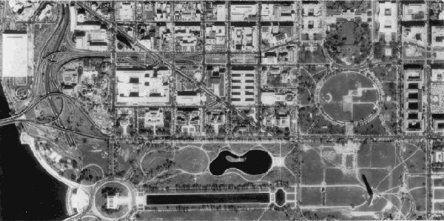
DOQ (Digital Orthophoto Quadrangle)
DOQ (Digital Orthophoto Quadrangle) is orthorectified aerial photograph data created in the United States. Primarily provided by the United States Geological Survey (USGS), it corrects distortions caused by terrain relief and camera tilt in aerial photographs, allowing it to be used as image data with the same coordinate accuracy as maps. DOQs are typically created for areas corresponding to quarter sections of 1:24,000 scale topographic maps (Quadrangles) and are characterized by their ability to accurately represent features such as roads, rivers, buildings, and vegetation based on actual geographic coordinates. Therefore, they are widely used as foundational data in diverse GIS applications including map creation, urban planning, and land use analysis.
2026-03-07 14:36:31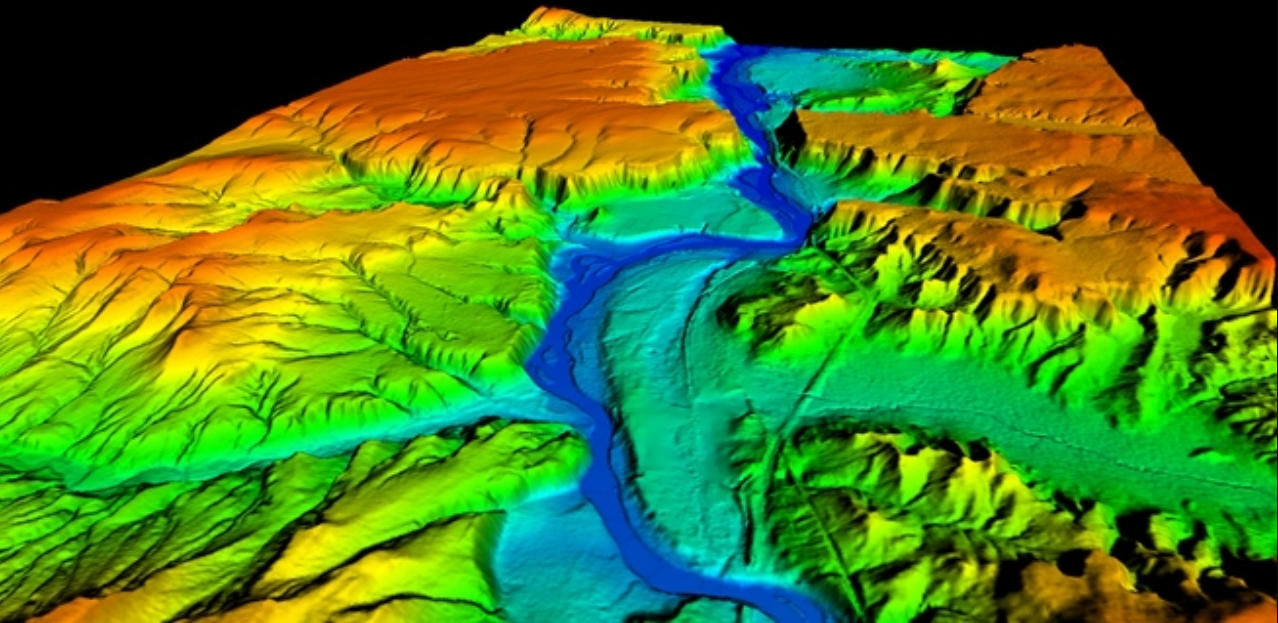
DTM (Digital Terrain Model)
DTM (Digital Terrain Model) is a type of geospatial data model that numerically represents the topography of the earth's surface. It records terrain relief, slopes, and topographic features in digital format, primarily focusing on ground elevation information, and is used for terrain analysis and geographic information processing. DTMs are typically expressed in formats such as grid-based raster data or TIN (Triangulated Irregular Network), and are characterized by representing "bare earth terrain" excluding features such as buildings and trees. They are often generated from survey data, airborne laser surveying (LiDAR), satellite remote sensing, and play an important role as foundational data in GIS and geographic analysis fields.
2026-03-07 14:41:07
ASCAT (Advanced Scatterometer)
ASCAT (Advanced Scatterometer) is a active microwave radar instrument carried aboard the MetOp series of polar-orbiting satellites operated by EUMETSAT . As a real aperture radar scatterometer, ASCAT transmits C-band (5.255 GHz) microwave pulses and measures the backscatter from the Earth's surface to derive key geophysical parameters . The primary operational application is ocean surface wind vector retrieval, providing measurements of wind speed and direction over global oceans . Additionally, ASCAT data is used for soil moisture monitoring over land surfaces and sea ice detection . The instrument features two independent swaths of backscatter measurements, enabling wide spatial coverage and frequent revisit times.
2026-03-07 14:46:13