 Service


Monte Mario (EPSG:4265)
Monte Mario (EPSG:4265) is Italy's official two-dimensional geographic coordinate system. Named after the Monte Mario datum and based on the International 1924 ellipsoid, it covers the entire territory of Italy (including San Marino and Vatican City). It is primarily used for geodetic surveying and offshore mineral management. Its coordinate axes are latitude and longitude, measured in degrees. It can be transformed to common coordinate systems such as WGS84 and ETRS89, with an accuracy of approximately 4 meters when transforming to WGS84.
2026-06-12 16:04:19
DHDN (Deutsches Hauptdreiecksnetz)
DHDN (Deutsches Hauptdreiecksnetz) is the old national geodetic datum of the Federal Republic of Germany, corresponding to EPSG code 4314. It is also often referred to as the Lauenberg Datum or Potsdam Datum. Based on the Bessel 1841 ellipsoid, its original fundamental point was TP Lauenberg. After this point was destroyed by sand and gravel extraction, the Helmert Tower in Potsdam became the new central point. DHDN served as the common coordinate basis for land surveying in the old federal states of Germany. With the advent of satellite geodetic techniques, the importance of the hierarchical triangulation network gradually declined. Starting in the 2010s, DHDN has been replaced by the ETRS89 coordinate system. Today, it is mainly used for onshore geodetic surveying and national digital mapping in the former West German states, covering areas such as Baden-Württemberg and Bavaria.
2026-06-12 15:54:25
AGD84 (Australian Geodetic Datum 1984) – EPSG:4203
AGD84 (Australian Geodetic Datum 1984) – EPSG:4203 is a regional geodetic datum that served as an interim update to AGD66, released by the Australian National Mapping Council in 1984. While still based on the Australian National Spheroid (ANS) and non-geocentric origin, AGD84 incorporated additional survey data and improved adjustment techniques, resulting in better positional accuracy than its predecessor. Unlike AGD66, which was a purely national adjustment, AGD84 included improved ties to international datums and incorporated Doppler satellite observations to better constrain the network. However, AGD84 was short-lived, as the shift toward geocentric datums (GDA94) began in the 1990s. Today, AGD84 is rarely used but remains relevant for certain legacy datasets produced during the late 1980s and early 1990s.
2026-05-14 19:27:30
AGD66 (Australian Geodetic Datum 1966) – EPSG:4202
AGD66 (Australian Geodetic Datum 1966) – EPSG:4202 is a regional geodetic datum that served as the official coordinate reference system for Australia from the late 1960s until its gradual replacement by GDA94 (Geocentric Datum of Australia 1994) in the 1990s. Developed by the Australian National Mapping Council, AGD66 was based on a network of approximately 1,200 survey stations adjusted using classical terrestrial measurements (triangulation and trilateration) and the Australian National Spheroid (ANS), a modified version of the GRS 1967 ellipsoid. Unlike modern geocentric datums, AGD66 is a local, Earth-fixed datum with its origin offset from the Earth's center by approximately 200 meters. While largely obsolete today, AGD66 remains important for interpreting legacy maps, historical GIS data, and older resource exploration records across Australia.
2026-05-14 19:22:36
NAD83(2011) – EPSG:6318
NAD83(2011) – EPSG:6318 is the most recent realization of the North American Datum of 1983 (NAD83), released by the U.S. National Geodetic Survey (NGS) in 2011 as part of the National Spatial Reference System (NSRS). It succeeded NAD83(NSRS2007) and represents the culmination of over a decade of GPS observations from approximately 2,000 Continuously Operating Reference Stations (CORS) and thousands of passive control marks. NAD83(2011) achieved improved alignment with the International Terrestrial Reference Frame (ITRF2008) while maintaining the plate-fixed nature of NAD83. It is currently the official NSRS realization recommended by the NGS for high-precision surveying, mapping, and GIS applications across the United States.
2026-05-14 19:18:49
NAD83(NSRS2007) – EPSG:4759
NAD83(NSRS2007) – EPSG:4759 is a realization of the North American Datum of 1983 (NAD83), released by the U.S. National Geodetic Survey (NGS) in 2007 as part of the National Spatial Reference System (NSRS). It succeeded NAD83(HARN) and preceded NAD83(2011). NSRS2007 was a nationwide re-adjustment that incorporated GPS observations from approximately 1,800 Continuously Operating Reference Stations (CORS) and thousands of survey markers, achieving consistent accuracy of approximately 0.01–0.05 meters across the entire United States. Unlike earlier realizations, NSRS2007 provided a single, unified, nationwide adjustment rather than state-by-state HARN adjustments.
2026-05-14 19:13:23
NAD83(HARN) – EPSG:4152
NAD83(HARN) – EPSG:4152 is a high-precision realization of the North American Datum of 1983 (NAD83), developed through the High Accuracy Reference Network (HARN) program by the U.S. National Geodetic Survey in the 1990s. By incorporating GPS observations, it improved positional accuracy to approximately 0.01–0.05 meters, significantly better than the original NAD83. While superseded by newer realizations, it remains widely used in legacy GIS data and local government applications across the United States.
2026-05-14 19:06:54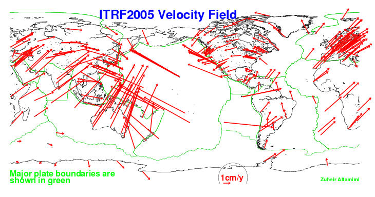
ITRF2005 (International Terrestrial Reference Frame 2005)
ITRF2005 (International Terrestrial Reference Frame 2005) is one of the international terrestrial reference systems, established by the International Earth Rotation and Reference Systems Service (IERS). ITRF2005 is a three-dimensional terrestrial coordinate system generated by integrating data from multiple space geodetic techniques, including GPS, VLBI, SLR, and DORIS. It defines the positions of observation points on the Earth's surface and their temporal changes with high precision. ITRF2005 adopts an Earth-Centered, Earth-Fixed (ECEF) coordinate system and is a dynamic reference frame that accounts for temporal changes such as crustal deformation and plate motion. It is widely used in GIS, satellite positioning, Earth science research, and other fields, and is registered under EPSG code EPSG:4896.
2026-04-20 15:33:33
ITRF2008 (International Terrestrial Reference Frame 2008)
ITRF2008 (International Terrestrial Reference Frame 2008) is an international three-dimensional terrestrial reference system constructed based on global geodetic observation data. Published by the International Earth Rotation and Reference Systems Service (IERS), which oversees global geodesy and Earth rotation observations, it is one of the international reference frames created by integrating multiple space geodetic techniques such as GNSS, VLBI, SLR, and DORIS. ITRF2008 is defined as a three-dimensional Cartesian coordinate system (X, Y, Z) with its origin at the Earth’s center, enabling high-precision positioning that accounts for plate motion and crustal deformation. It is widely used as a reference frame in many satellite positioning systems and international geodetic networks, forming the foundation for Earth science research and high-precision positioning. In EPSG, it is defined as EPSG:5332.
2026-04-20 15:28:58
WGS84 / Pseudo-Mercator (EPSG:3857)
WGS84 / Pseudo-Mercator (EPSG:3857) is a projected coordinate system widely used in modern web mapping services. It is based on the WGS 84 geographic coordinate system and employs a simplified version of the traditional Mercator projection adapted for web display. Primarily designed for rendering tile-based web maps, it serves as the standard display coordinate system for online map services and GIS platforms. By converting geographic coordinates expressed in degrees to plane coordinates in meters, it facilitates fast map rendering and zooming operations.
2026-04-14 19:31:45