FBN (Feature Binary Node)
FBN file is a format used for visualization and management of 3D models and geospatial data, mainly suitable for the management and display of large-scale 3D scenes and city models. This format is optimized to efficiently load and render large volumes of data, and is widely used in fields such as GIS (Geographic Information System) and digital twins. FBN files can package and store model data, texture information, geographic coordinates, attribute data, etc., so that high-speed rendering can be achieved while maintaining 3D scene reproducibility and data consistency.
2025-09-16 14:48:01AVF (Advanced Vector Format)
AVF is the abbreviation of Advanced Vector Format. It is a file format used to store and transmit vector data and is widely used in GIS software and systems. AVF format stores vector data in binary form, including geographic features such as points, lines, and surfaces and their attribute information.
2025-09-16 14:47:39Esri Grid
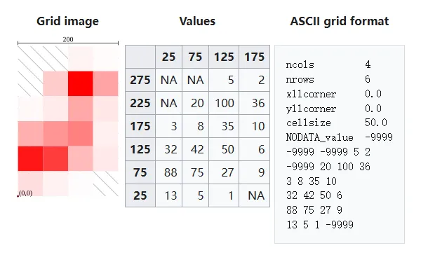
Esri Grid is a type of raster data format developed by the Environmental Systems Research Institute (ESRI) in the United States. It is a format that is mainly used as a standard in the ArcGIS product group and is used to divide geospatial information into a grid and manage it. Numerical information (elevation value, classification code, etc.) is stored in each cell, and it is used in a wide range of GIS (geographic information system) applications such as topographic analysis, land use classification, and climate data analysis.
2025-09-16 14:48:07DAT(Data)
DAT files are a general-purpose binary data file format that is widely used to store different types of data, such as program configuration information, images, audio, video, spreadsheets, database files, etc. They are usually created and read by applications to store application-specific information, and the specific content and format depend on the application that created it.
2025-09-16 14:47:25TIFF (Tagged Image File Format)
TIFF (Tagged Image File Format) is a commonly used image file format that supports multiple compression methods and color models, and can store multi-page documents, image metadata, alpha channels and other information. TIFF files are usually used in high-quality prints, publications and image processing, and can also be used to store scanned paper documents or photos. Due to its support for flexible pixel and metadata storage, TIFF format has been widely used in many industries.
2025-09-16 14:47:28NC (NetCDF, Network Common Data Form)
NC (NetCDF, Network Common Data Form) is a self-describing, cross-platform scientific data format, widely used in meteorology, oceanography, earth science and other fields, for storing multidimensional array data (such as temperature, rainfall, wind speed, etc.). NetCDF is developed and maintained by Unidata and is one of the important standards in the field of scientific computing and analysis. It uses a hierarchical data model to store data in the form of variables, dimensions and attributes, making it flexible to represent complex scientific data sets while being efficient and easy to use.
2025-09-16 14:47:36VMDS (Visual Model Data Stream)
VMDS (Visual Model Data Stream) is an efficient file format for 3D model data, designed for real-time rendering and fast loading of complex scenes. VMDS files are usually used to store and transmit 3D models, materials, animations, and related metadata. With streaming and compression as its core features, it supports efficient processing of large-scale 3D scenes, and is therefore widely used in game development, virtual reality (VR), augmented reality (AR), and geographic information systems (GIS).
2025-09-16 14:47:36SDX (Spatial Data Exchange)
SDX (Spatial Data Exchange) is a common file format used to share and transfer spatial data between different GIS software. It can contain vector data and raster data, as well as attribute information related to them. They can store the geometry, topological relationships, attribute data, and spatial reference information of geographic features. By using SDX files, users can import, export, and share geographic data in different GIS software to achieve data interoperability and scalability.
2025-09-16 14:47:54QGZ (Quantum GIS Zipped Project)
QGZ files are compressed file formats used to save projects in QGIS (Quantum GIS) software. QGIS is an open source geographic information system (GIS) software that is widely used for visualization, editing, and analysis of spatial data. The QGZ format essentially compresses the configuration files (.qgs files in XML format) of the QGIS project into a single file for easy storage and transmission. Unlike QGS files, the QGZ format has better storage management capabilities and is particularly suitable for handling complex projects.
2025-09-16 14:47:43
 Service

