
 Service

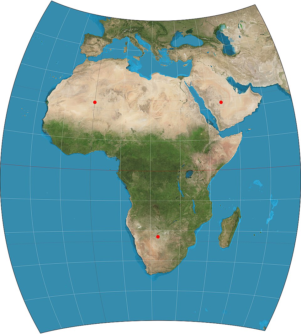
Chamberlin Trimetric Projection
Chamberlin Trimetric Projection is a map projection method devised by William Chamberlin in the early 20th century. This projection is characterized by its accurate preservation of distances from any three arbitrarily chosen points on the Earth's surface. It is classified as a "compromise projection," as it does not fully belong to any of the conformal, equal-area, or equidistant categories. It excels in representing regions centered around specific reference points and has been used for experimental and academic purposes to intuitively understand geographical relationships.
2025-12-29 14:35:59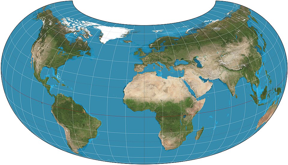
Armadillo Projection
Armadillo Projection is a relatively new world map projection designed to represent the entire Earth on a single plane in a visually striking manner. It prioritizes visual continuity and artistic expression over geometric accuracy, featuring a unique shape that appears to wrap around the globe. Primarily used for educational purposes, design, and visualization, it is known as a projection that offers a fresh perspective on presenting geographic information.
2025-12-29 14:31:07
Balthasart Cylindrical Projection
Balthasart Cylindrical Projection is a map projection method belonging to the cylindrical projection family. Cylindrical projections involve projecting the spherical surface onto a cylindrical surface, which is then unfolded, resulting in both meridians and parallels appearing as straight lines that intersect orthogonally. In this projection, the direction does not necessarily have to align with the Earth's axis (meaning the line of tangency between the sphere and the cylinder is not necessarily the equator), as any angle is possible. Based on the relative orientation of the projection surface to the Earth, it can be categorized into normal-axis, transverse-axis, oblique-axis cylindrical projections, as well as tangent and secant cylindrical projections. In the normal-axis projection, parallels are straight parallel lines, while meridians are straight parallel lines equally spaced and perpendicular to the parallels. The Balthasart Cylindrical Projection is primarily used for drawing world or regional maps, especially for index maps. It is suitable for low-latitude regions near the equator, while transverse or oblique-axis cylindrical projections are better suited for areas extending along a meridian or a specific great circle direction.
2025-12-29 14:24:06
Behrmann Cylindrical Equal-Area Projection
The Behrmann Cylindrical Equal-Area Projection is an equal-area azimuthal projection distinguished by its ability to accurately preserve distances and directions from a central point. By projecting each point on the Earth onto a flat surface, this projection method faithfully represents geographical features and relative positional relationships, making it widely applicable in fields such as cartography and geographic information systems.
2025-12-08 16:15:50
Boggs Eumorphic Projection
Boggs Eumorphic Projection is a pseudocylindrical equal-area map projection used for world maps, often featuring multiple interruptions. Its equal-area characteristic makes it suitable for displaying the spatial distribution of phenomena. Proposed by Samuel Whittemore Boggs (1889–1954) in 1929, this projection aimed to provide an alternative to the Mercator projection for representing global regional relationships. Boggs served as the Geographer of the U.S. Department of State from 1924 until his death. The Boggs Eumorphic Projection is occasionally used in textbooks and atlases.
2025-11-27 15:51:07
Hammer–Aitoff variant
Hammer–Aitoff variant is an improved version of the Lambert azimuthal equal-area projection. The Hammer projection is an equal-area projection with an elliptical graticule. It is also referred to as the Hammer–Aitoff projection. This projection is suitable for small-scale mapping.
2025-11-27 15:46:29
Aitoff Projection
Aitoff projection is a specialized map projection method first proposed by the German mathematician David A. Aitoff in 1889. As a compromise projection, it aims to balance distortions in angle, area, and distance, making it suitable for global overview maps. The Aitoff projection is an improvement upon the azimuthal equidistant projection. By horizontally stretching the original hemispherical projection to twice its width, it forms an elliptical map where the width is double the height. This projection is particularly well-suited for displaying regions centered on specific points, such as polar areas or cities, while providing a relatively balanced view of the world.
2025-11-27 15:42:04
New Zealand Map Grid Projection
New Zealand Map Grid Projection is a conformal map projection technology specifically designed for large-scale mapping of New Zealand. It employs the complex Cauchy-Riemann equations for projection calculations, with its central point set at 173° East longitude and 41° South latitude. It is important to note that this projection method is only suitable for large-scale mapping within New Zealand and may not be applicable for mapping other regions.
2025-11-24 16:30:22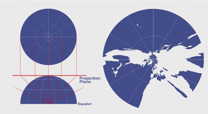
Gnomonic Projection
Gnomonic Projection is a perspective azimuthal projection that uses the center of the sphere as the light source. It projects great circles on the spherical surface (such as meridians and the equator) as straight lines, making it commonly used in navigation, astronomy, and seismic analysis. Its key characteristic is the absence of distortion at the projection center, but extreme distortion occurs at the edges. While suitable for mapping great-circle routes or analyzing linear paths, it does not preserve area or angular relationships.
2025-11-24 16:25:01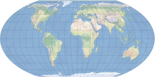
Wagner IV Projection
Wagner IV Projection is an equal area pseudo cylindrical map projection proposed by Karl Wagner, suitable for world map drawing. Its characteristics are that the longitude is an elliptical curve, the latitude is a straight line, the poles are straight and half the length of the equator, it can maintain equal area but has distortion in shape and angle, especially suitable for small-scale equal area world maps.
2025-11-05 16:06:49