 Service

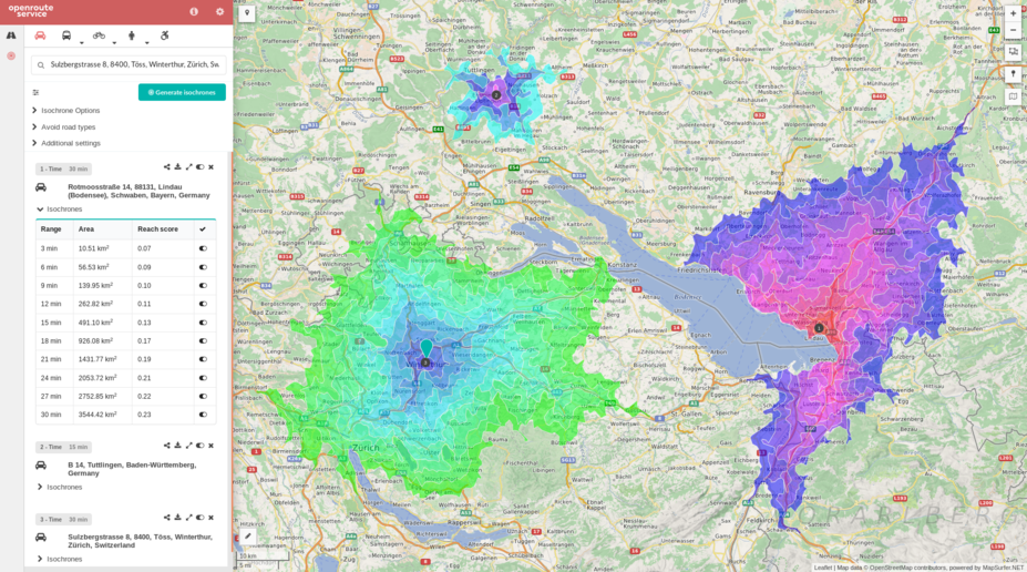
OpenRouteService API
OpenRouteService API is an application programming interface (API) that provides route planning, navigation, and geocoding services. It supports multiple transportation modes (such as walking, cycling, driving, etc.) and can be integrated into map applications to enable route calculation and navigation functionality. Through its open interface, it offers location-based services for developers, making it suitable for application development requiring route optimization or navigation features.
2025-12-29 14:05:48
GraphHopper Directions API
GraphHopper Directions API is a route planning and navigation service based on a RESTful architecture, provided by GraphHopper GmbH. It leverages OpenStreetMap data to provide global map coverage and supports route calculation for multiple modes of transportation (such as driving, cycling, walking, public transit, etc.). It integrates functionalities like real-time traffic information, route optimization, geocoding, and isochrone analysis. Developers can quickly integrate it into applications using its Java or JavaScript clients. It is suitable for scenarios like logistics and distribution, traffic navigation, and geographic information systems, combining open-source flexibility with commercial-grade performance.
2025-12-29 14:00:14
OSRM API (Open Source Routing Machine)
OSRM API (Open Source Routing Machine) is a high-performance open-source routing engine based on OpenStreetMap data, providing route calculation services through RESTful HTTP interfaces. It supports multiple travel modes such as driving, cycling, and walking, and can quickly return the shortest path results. It is widely used in navigation application development, logistics delivery planning, travel time analysis, and other scenarios. Core features include route calculation, multi-point travel time matrix generation, GPS trajectory matching, etc., utilizing the Contraction Hierarchies algorithm to achieve millisecond-level response times.
2025-12-29 13:55:31
Esri Spatial Analysis / Geometry API
ESRI Spatial Analysis is the core spatial analysis toolkit within the ArcGIS platform, supporting advanced spatial modeling techniques such as terrain modeling, location analysis, pattern recognition, and change detection. The Geometry API provides geometric object processing capabilities, including point/line/polygon operations, spatial relationship analysis, and geometric calculations, with support for standard formats such as GeoJSON and WKT. Both are integrated into ArcGIS Pro and the Python API, require specific licenses (such as a Spatial Analyst license), and it is recommended to migrate from ArcGIS Desktop to ArcGIS Pro for use.
2025-12-29 13:48:22
Esri GeoEvent Server
Esri GeoEvent Server is an enterprise-level software provided by Esri, designed for real-time processing, analysis, and dissemination of event-based geospatial data streams. It can connect to multiple real-time data sources, perform real-time analysis on event data through filters and processors, and deliver processed results to client applications, feature services, dashboards, or other destinations. This technology is commonly used in smart cities, traffic monitoring, and other scenarios requiring real-time responsiveness, helping users quickly adapt to dynamic changes.
2025-11-24 15:46:07_1763970235051.jpg)
MapQuest API
MapQuest API is an application programming interface that provides location-based services such as geocoding, route planning, and POI search. Developers can invoke its services by sending HTTP requests, for example, to convert addresses into coordinates or calculate driving routes. It supports multiple map data sources (e.g., OpenStreetMap, Bing Maps) and allows free access to basic services through an API key. This API is commonly used in scenarios like logistics optimization and location sharing. For instance, one organization utilized it to reduce meal delivery route planning time and costs.
2025-11-24 15:41:17
TomTom Maps SDK / Web API
TomTom Maps SDK / Web API is a toolkit integrated into web and mobile applications to build location-based service experiences. It provides map display, route planning, style customization, and data analysis capabilities, supporting multi-platform usage. The SDK allows developers to display multiple entity locations simultaneously on maps via API calls and leverages millions of data points collected by TomTom for efficient development. Compatible with both web-based and native mobile application platforms, it is suitable for various scenarios such as automotive navigation, public sector decision-making, autonomous driving, and logistics management.
2025-11-24 15:35:34
Carto Tiles API
CARTO Tiles API is an interface provided by the CARTO platform for efficiently processing and visualizing geospatial data. By splitting large datasets into pre-rendered tiles, it optimizes map loading speed and browsing experience, supporting various tile types such as dynamic and aggregated tiles. Built on the OGC API-Tiles standard, it integrates with CARTO’s declarative language, deck.gl, enabling flexible map styling and interactive application development.
2025-11-24 15:29:47
Mapillary Image Matching API
Mapillary Image Matching API is an interface service based on image matching technology, which aims to achieve spatial consistency and feature correspondence between multiple images using computer vision algorithms. This API detects key points (feature points) such as SIFT and ORB, and calculates a homography matrix to geometrically align images taken from different viewpoints or at different times.
2025-11-05 14:43:52
Mapillary Vector Tiles API
Mapillary Vector Tiles API is an interface that provides structured vector map data, providing developers with the geographic locations and attributes of real-world objects (e.g., road markings, traffic signs, lanes, and road shapes) collected by the Mapillary platform in the form of efficiently transportable "tiles." Developers can use this highly accurate vector data to build applications such as augmented reality (AR) navigation, detailed map analysis, and infrastructure management tools.
2025-11-05 14:42:28