Service


Yandex Maps API
Yandex Maps API is a map service API provided by Russian Internet giant Yandex. It allows developers to embed Yandex maps into websites or applications, realizing functions such as map display, location search, route planning, geocoding and de-geocoding, and supports the creation of interactive map applications and enriches geographic spatial functions.and spatial data through a browser without installing specialized software. It supports multi-terminal access and team collaboration, and integrates authoritative global basemaps and analysis tools. It is suitable for governments, businesses, and educational institutions to quickly visualize and apply geographic information.
2025-11-05 14:28:33
Esri ArcGIS Online
Esri ArcGIS Online is a cloud-based geographic information system (GIS) platform that allows users to create, edit, and share interactive maps and spatial data through a browser without installing specialized software. It supports multi-terminal access and team collaboration, and integrates authoritative global basemaps and analysis tools. It is suitable for governments, businesses, and educational institutions to quickly visualize and apply geographic information.
2025-11-05 14:27:43
OpenStreetMap (OSM)
OpenStreetMap (OSM) is an open-source, editable global geographic data project. Volunteers from around the world work together to create free and detailed maps by collecting, editing and sharing geographic information (such as roads, buildings, rivers, etc.). Its data can be used free of charge for various applications, providing a flexible and open geographic data foundation for commercial, scientific research and personal projects.
2025-11-05 14:25:50
TomTom Maps API
TomTom Maps API is a development interface provided by TomTom, a leading global location-based technology company, for integrating mapping, navigation, traffic information, and location search functionality into various applications. It allows developers to access real-time map data, route planning, geocoding, and other services. It is suitable for scenarios such as in-vehicle systems, logistics management, and mobile applications, and features high accuracy and global coverage.
2025-11-05 14:24:20
HERE Maps API
HERE Maps API is a suite of mapping and location-based service APIs provided by Germany-based HERE Technologies. Widely used in web applications, mobile apps, and enterprise systems, it primarily provides functionality such as map display, route navigation, location search, geocoding, and traffic information. With its high-precision map data and real-time traffic information, it has been widely adopted in the automotive industry, logistics, smart city development, and other fields.
2025-11-05 14:22:56
Mapbox
Mapbox is a US-based map and location service provider that provides APIs and SDKs for developers to help them build custom map apps and visualization tools. It covers map data from all over the world and uses WebGL technology to create high-performance 2D and 3D maps. It supports real-time data visualization, route calculation, geocoding, and other features. By utilizing an open source toolchain, you can quickly build location-based services in a variety of fields, including navigation, logistics, and smart cities. It features vector tile technology and a flexible style system, and also provides global base map data and satellite imagery.
2025-11-05 14:21:40_1762323693444.png)
Google Maps Platform
Google Maps Platform is one of the most widely used map services in the world, providing detailed map data, navigation, real-time traffic information, Street View imagery, and more. It is a cloud-based map service provided by Google, and through a wide range of APIs and SDKs, developers can integrate map display, route guidance, spot search, and other functions into their own applications. It is used in a wide range of industries, including logistics, retail, and mobility.
2025-11-05 14:20:33
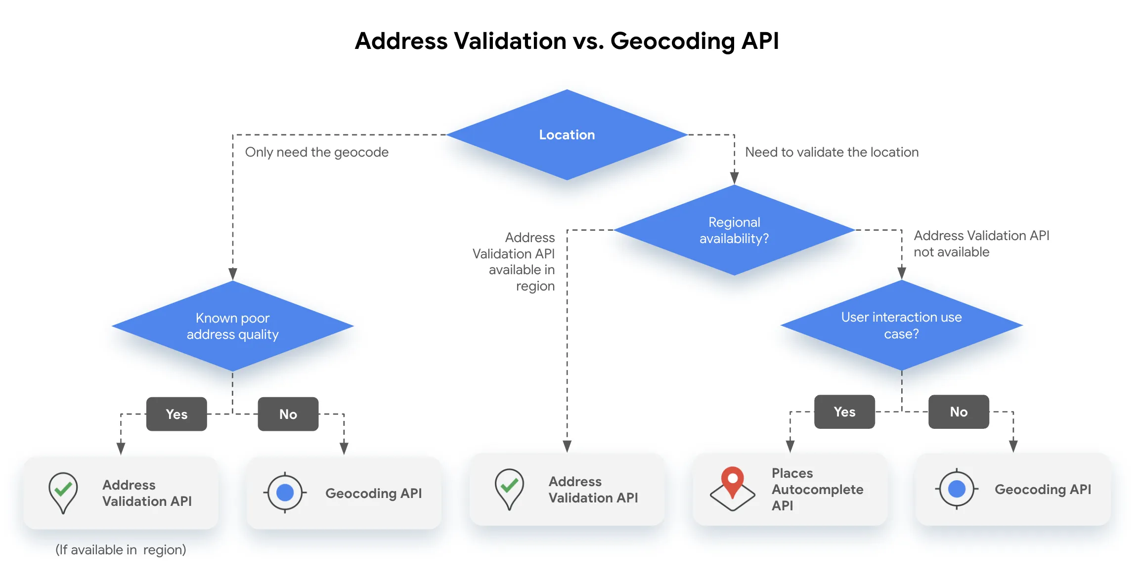
Routing API
Reverse Geocoding API is a technical interface that converts longitude and latitude coordinates into human-readable addresses. It automatically returns the corresponding structured address information (such as "Tiananmen Square, Dongcheng District, Beijing") by inputting GPS coordinates (such as 116.404,39.915), and supports the attachment of surrounding POI (points of interest) data. This service is widely used in map navigation, logistics tracking, location analysis and other scenarios, and is one of the core components of LBS (location-based services).
2025-11-05 14:19:20_1762323506153.png)
Reverse Geocoding API
Reverse Geocoding API is a technical interface that converts longitude and latitude coordinates into human-readable addresses. It automatically returns the corresponding structured address information (such as "Tiananmen Square, Dongcheng District, Beijing") by inputting GPS coordinates (such as 116.404,39.915), and supports the attachment of surrounding POI (points of interest) data. This service is widely used in map navigation, logistics tracking, location analysis and other scenarios, and is one of the core components of LBS (location-based services).
2025-11-05 14:17:26