 Service

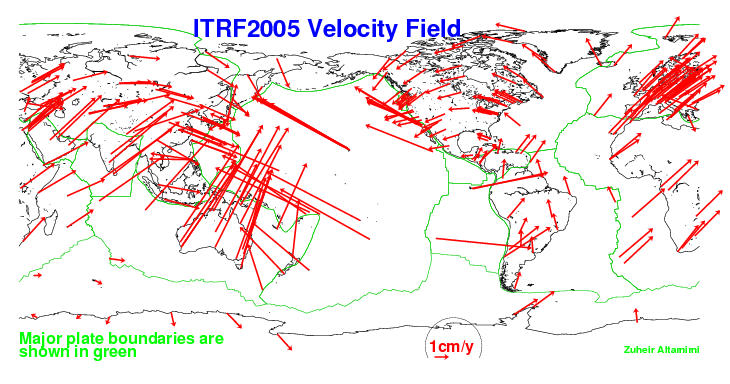
ITRF2005 (International Terrestrial Reference Frame 2005)
ITRF2005 (International Terrestrial Reference Frame 2005) is one of the international terrestrial reference systems, established by the International Earth Rotation and Reference Systems Service (IERS). ITRF2005 is a three-dimensional terrestrial coordinate system generated by integrating data from multiple space geodetic techniques, including GPS, VLBI, SLR, and DORIS. It defines the positions of observation points on the Earth's surface and their temporal changes with high precision. ITRF2005 adopts an Earth-Centered, Earth-Fixed (ECEF) coordinate system and is a dynamic reference frame that accounts for temporal changes such as crustal deformation and plate motion. It is widely used in GIS, satellite positioning, Earth science research, and other fields, and is registered under EPSG code EPSG:4896.
2026-04-20 15:33:33
ITRF2008 (International Terrestrial Reference Frame 2008)
ITRF2008 (International Terrestrial Reference Frame 2008) is an international three-dimensional terrestrial reference system constructed based on global geodetic observation data. Published by the International Earth Rotation and Reference Systems Service (IERS), which oversees global geodesy and Earth rotation observations, it is one of the international reference frames created by integrating multiple space geodetic techniques such as GNSS, VLBI, SLR, and DORIS. ITRF2008 is defined as a three-dimensional Cartesian coordinate system (X, Y, Z) with its origin at the Earth’s center, enabling high-precision positioning that accounts for plate motion and crustal deformation. It is widely used as a reference frame in many satellite positioning systems and international geodetic networks, forming the foundation for Earth science research and high-precision positioning. In EPSG, it is defined as EPSG:5332.
2026-04-20 15:28:58
WGS84 / Pseudo-Mercator (EPSG:3857)
WGS84 / Pseudo-Mercator (EPSG:3857) is a projected coordinate system widely used in modern web mapping services. It is based on the WGS 84 geographic coordinate system and employs a simplified version of the traditional Mercator projection adapted for web display. Primarily designed for rendering tile-based web maps, it serves as the standard display coordinate system for online map services and GIS platforms. By converting geographic coordinates expressed in degrees to plane coordinates in meters, it facilitates fast map rendering and zooming operations.
2026-04-14 19:31:45
WGS84 (G1674) (World Geodetic System 1984)
WGS84 (G1674) is one of the updated realizations of the globally used World Geodetic System 1984 (WGS84), a frame that has been improved in accuracy based on GNSS observation data. The EPSG code EPSG:4979 defines a three-dimensional geographic coordinate system that represents a position using three components: latitude, longitude, and ellipsoidal height. WGS84 (G1674) is primarily used in global navigation satellite systems and is widely employed as the positioning reference, especially for GPS. Based on an Earth-Centered, Earth-Fixed (ECEF) framework and using an Earth ellipsoid model, it enables highly accurate representation of positions on the Earth's surface.
2026-04-14 19:26:19
Pulkovo 1942 / Gauss–Krüger projection
Pulkovo 1942 / Gauss–Krüger projection is a combination of a geodetic datum and a projection method widely used in the former Soviet Union and Eastern Europe. Pulkovo 1942 is a national geodetic datum established by the Soviet Union, adopting the Krasovsky ellipsoid as its reference ellipsoid. The Gauss–Krüger projection is a transverse Mercator projection that converts the Earth's surface into plane coordinates using longitudinal zones. This combination was used for decades in topographic mapping, military surveying, cadastral surveying, and other applications across the former Soviet republics.
2026-04-14 19:21:53
Adams World in a Square I Projection
Adams World in a Square I Projection is a conformal map projection developed by American mathematician and astronomer Oscar Sherman Adams in 1925. Adams, who worked at the U.S. Coast and Geodetic Survey, was a prolific contributor to theoretical cartography, known for his work on conformal projections and his adaptation of the Peirce quincuncial concept. The "World in a Square I" (often referred to as simply the Adams Square I projection) represents the Earth within a perfect square, with the poles located at two opposite corners. It is a member of the same conformal family as the Guyou and Peirce quincuncial projections, and like them, it relies on elliptical functions for its mathematical construction. The projection is notable for its ability to be tiled seamlessly in both directions, allowing the entire sphere to be represented without interruption in a compact, aesthetically striking square format.
2026-04-14 19:15:55
Guyou Projection
Guyou projection is a conformal map projection proposed by French mathematician and naval captain Émile Guyou in 1886. As a member of the French Academy of Sciences (elected 1894) and a recipient of the Légion d'Honneur, Guyou developed this projection as an elegant solution for displaying the world in a rectangular form while preserving local angles. The projection belongs to the same family as the Peirce quincuncial projection—in fact, the Guyou and Peirce projections are transverse cases of each other: Guyou represents the equatorial aspect, while Peirce represents the polar aspect. Though mathematically complex, relying on elliptical integrals for its computation, the Guyou projection offers the unique ability to be tiled infinitely, allowing any point on Earth to be connected to any other by a straight line.
2026-04-14 19:10:48
Littrow Projection
Littrow Projection is a unique conformal retroazimuthal map projection proposed by Austrian astronomer and cartographer Joseph Johann von Littrow in 1833. It stands out as the only map projection that combines both conformal and retroazimuthal properties, a rare dual characteristic that distinguishes it from all other projection designs. Later independently reinvented by British Merchant Navy’s Patrick Weir in 1890, it is also occasionally referred to as the Weir Azimuth Diagram. Unlike global projections designed for world maps, the Littrow Projection is specialized for directional measurement, presenting a limited geographic scope with hyperbolic meridians and elliptical parallels. It cannot display the entire globe, focusing instead on preserving local angles and accurate azimuths toward a predefined central point.
2026-04-14 19:03:51
Eckert VI Projection
Eckert VI Projection is a pseudocylindrical equal-area map projection proposed by German cartographer Max Eckert in 1906. As the sixth and most widely recognized projection in the Eckert series, it represents a significant departure from the earlier Eckert I–V designs. Unlike its predecessors, Eckert VI features equally spaced straight parallels and curved meridians that are elliptical arcs, with the central meridian appearing as a straight line half the length of the equator. The poles are represented as points (rather than lines), creating a more conventional and visually appealing world map while maintaining strict equal-area properties. This projection is often compared favorably to the Robinson projection in terms of aesthetic balance.
2026-04-03 15:47:54
Eckert II Projection
Eckert II Projection is a pseudocylindrical equal-area map projection proposed by German cartographer Max Eckert in 1906. As the second projection in the Eckert series, it shares the same geometric framework as Eckert I—equally spaced straight meridians interrupted at the equator, a central meridian half the length of the equator, and uniformly distributed straight parallels—but introduces a critical mathematical modification to achieve equal-area property. The poles are represented as straight lines half the length of the equator, and the projection maintains zero area distortion globally, making it a rare example of a simple pseudocylindrical equal-area projection.
2026-04-03 15:44:37