Service


GPF-DIME(Geospatial Product Format - Digital Image Management Environment)
GPF-DIME is a file format used to manage and store remote sensing image data and other geospatial data. It is mainly used for the storage, processing and transmission of remote sensing images. By providing a flexible and efficient data structure, this format allows users to use it to store and process images in different environments, especially when processing large-scale, high-resolution image data.
2025-09-16 14:47:26
DAT(Data)
DAT files are a general-purpose binary data file format that is widely used to store different types of data, such as program configuration information, images, audio, video, spreadsheets, database files, etc. They are usually created and read by applications to store application-specific information, and the specific content and format depend on the application that created it.
2025-09-16 14:47:25
MAP(Map File)
MAP (Map) is a visualization tool based on geographic location information, which displays geographic location and geographic data in a graphical way. In GIS, MAP usually refers to a map file, which contains the basic data, style and metadata of the map. Map files can be created by GIS software or provided by third-party data providers. In GIS, map files can be used to better manage and organize map data and make it easier to share and integrate with other GIS software.
2025-09-16 14:47:25
ID(Identification File)
In GIS (Geographic Information System), ID files usually refer to identification files, which are files used to identify data sets. They usually contain metadata information such as the name, version, author, format, creation date, scope, and summary of the data set to help users understand and manage the data set. The format of the ID file can be a text file, XML file, or other structured format. In GIS, the metadata information of the data is very important, which can help users better understand the data set, evaluate data quality, and select appropriate data and analysis methods. Therefore, the ID file is also very important.
2025-09-16 14:47:25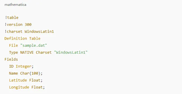
TAB(Table File)
TAB file is a file format used to describe geographic spatial data. It is usually a logical “data table”, but it not only contains tabular data, but also links to other files to provide spatial reference and geometric data. It is the main format for MapInfo software to read and write spatial data. It is suitable for storing vector data types such as points, lines, polygons, and can support topological structures and coordinate information. It is widely used in the GIS industry for its good structure and powerful functions, and can store spatial data and related attribute data.
2025-09-16 14:47:24
VDC(Virtual Design and Construction)
VDC (Virtual Design and Construction) is a technology and methodology used in the fields of architecture, engineering and construction (AEC). It combines building information modeling (BIM), 3D visualization and other digital tools to perform virtual simulation and management during the design, planning and construction stages of a project. By digitizing the construction process of the entire project, VDC can optimize collaboration, improve efficiency and reduce risks, thereby increasing the success rate and profitability of the project.
2025-09-16 14:47:24
GPX(GPS eXchange Format)
GPX is an XML-based file format specifically designed for exchanging GPS data. It is widely used to describe location information, such as routes, tracks, and points of interest (POIs), making it easy to share and transfer data between different GPS devices and software. As an open standard, the GPX format is supported by many applications and devices, such as sports trackers, map software, and navigation systems.
2025-09-16 14:47:24
VCT(Vector Product Format)
**VCT **(Vector Product Format) is a vector data format commonly used in geographic information systems (GIS) and spatial data management. The format is designed to support data storage and exchange of complex geographic objects and provide efficient spatial data processing and application. The VCT format has attracted widespread attention for its flexibility and efficient storage structure, especially in scenarios where large amounts of spatial data need to be quickly queried and processed.
2025-09-16 14:47:24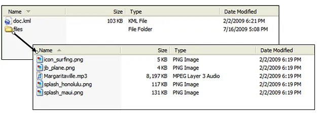
KMZ (Keyhole Markup Language Zipped)
KMZ is a file format for geospatial data and is a compressed version of a KML (Keyhole Markup Language) file. KML is a standardized markup language developed by Google for representing geospatial information and displaying it in mapping applications such as Google Earth and Google Maps. KMZ files reduce the file size by compressing the KML file and its associated resources (such as images and 3D models), making them easier to transfer and share.
2025-09-16 14:47:23